File:Mansfieldtown Church, Co. Louth - geograph.org.uk - 1326609.jpg
Jump to navigation
Jump to search
No higher resolution available.
Mansfieldtown_Church,_Co._Louth_-_geograph.org.uk_-_1326609.jpg (640 × 421 pixels, file size: 81 KB, MIME type: image/jpeg)
Captions
Captions
Add a one-line explanation of what this file represents
Summary
[edit]
| Description |
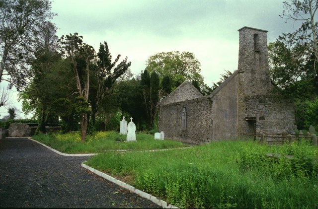
English: Mansfieldtown Church, Co. Louth St. Mary's Church, a simple rectangular structure built in 1691 but with a 15th-century gothic east window rebuilt in the far gable. Leslie in his 'History of Kilsaran', published 1908, states that the townland name is derived from the Anglo-Norman family of Maundeville who settled here soon after 1172. A photograph in the book shows the church roofed. The earliest reference to the church is in the Papal Registers dated 1299. A large decorated c. 15th-century font from here is now in St. Mary's Parish Church, Ardee. |
| Date | |
| Source | From geograph.org.uk |
| Author | Kieran Campbell |
| Attribution (required by the license) | Kieran Campbell / Mansfieldtown Church, Co. Louth / |
| Camera location | | View this and other nearby images on: OpenStreetMap |
|---|
_heading:112.00&language=en)
| Object location | | View this and other nearby images on: OpenStreetMap |
|---|
_heading:112.00&language=en)
Licensing
[edit]

|
This image was taken from the Geograph project collection. See this photograph's page on the Geograph website for the photographer's contact details. The copyright on this image is owned by Kieran Campbell and is licensed for reuse under the Creative Commons Attribution-ShareAlike 2.0 license.
|
This file is licensed under the Creative Commons Attribution-Share Alike 2.0 Generic license.
Attribution: Kieran Campbell
- You are free:
- to share – to copy, distribute and transmit the work
- to remix – to adapt the work
- Under the following conditions:
- attribution – You must give appropriate credit, provide a link to the license, and indicate if changes were made. You may do so in any reasonable manner, but not in any way that suggests the licensor endorses you or your use.
- share alike – If you remix, transform, or build upon the material, you must distribute your contributions under the same or compatible license as the original.
File history
Click on a date/time to view the file as it appeared at that time.
| Date/Time | Thumbnail | Dimensions | User | Comment | |
|---|---|---|---|---|---|
| current | 21:48, 27 February 2011 | | 640 × 421 (81 KB) | GeographBot (talk | contribs) | == {{int:filedesc}} == {{Information |description={{en|1=Mansfieldtown Church, Co. Louth St. Mary's Church, a simple rectangular structure built in 1691 but with a 15th-century gothic east window rebuilt in the far gable. Leslie in his 'History of Kilsara |
You cannot overwrite this file.
File usage on Commons
There are no pages that use this file.
File usage on other wikis
The following other wikis use this file:
- Usage on arz.wikipedia.org
- Usage on en.wikipedia.org
- Usage on www.wikidata.org