File:Mahajanga Boriziny.png
Jump to navigation
Jump to search
No higher resolution available.
Mahajanga_Boriziny.png (250 × 246 pixels, file size: 6 KB, MIME type: image/png)
Captions
Captions
Add a one-line explanation of what this file represents
| Description |
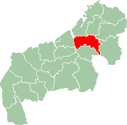
English: Location map of Boriziny region in Mahajanga province.
Français : Carte de localisation de la région de Boriziny dans la province de Mahajanga. |
||||||||
| Date | 28 March 2007 (original upload date) | ||||||||
| Source | Transferred from en.wikipedia to Commons. | ||||||||
| Author | The original uploader was 8thstar at English Wikipedia. | ||||||||
| Permission (Reusing this file) |
8thstar at the English-language Wikipedia, the copyright holder of this work, hereby publishes it under the following license:
|

Original upload log
[edit]
The original description page was here. All following user names refer to en.wikipedia.
- 2007-03-28 18:55 8thstar 250×246×8 (5671 bytes)
File history
Click on a date/time to view the file as it appeared at that time.
| Date/Time | Thumbnail | Dimensions | User | Comment | |
|---|---|---|---|---|---|
| current | 10:20, 28 September 2007 | | 250 × 246 (6 KB) | Alno (talk | contribs) | {{Information |Description= {{en|Location map of Boriziny region in Mahajanga province.}} {{fr|Carte de localisation de la région de Boriziny dans la province de Mahajanga.}} |Source=Originally from [http://en.wikipedia.org en.wikipedia]; description pag |
You cannot overwrite this file.
File usage on Commons
The following page uses this file:
File usage on other wikis
The following other wikis use this file:
- Usage on en.wikipedia.org
- Usage on es.wikipedia.org
- Usage on ha.wikipedia.org
- Usage on ig.wikipedia.org
- Usage on it.wikipedia.org
- Usage on mg.wikipedia.org
- Usage on ro.wikipedia.org
- Usage on ts.wikipedia.org
- Usage on www.wikidata.org
- Usage on yo.wikipedia.org
- Usage on zu.wikipedia.org