File:Magyarországi Nepomuki Szent János-szobrok térképe.png
Jump to navigation
Jump to search
Size of this preview: 800 × 454 pixels. Other resolutions: 320 × 182 pixels | 640 × 363 pixels | 1,024 × 581 pixels | 1,280 × 726 pixels | 2,560 × 1,453 pixels | 6,128 × 3,477 pixels.
Original file (6,128 × 3,477 pixels, file size: 1.01 MB, MIME type: image/png)
Captions
Captions
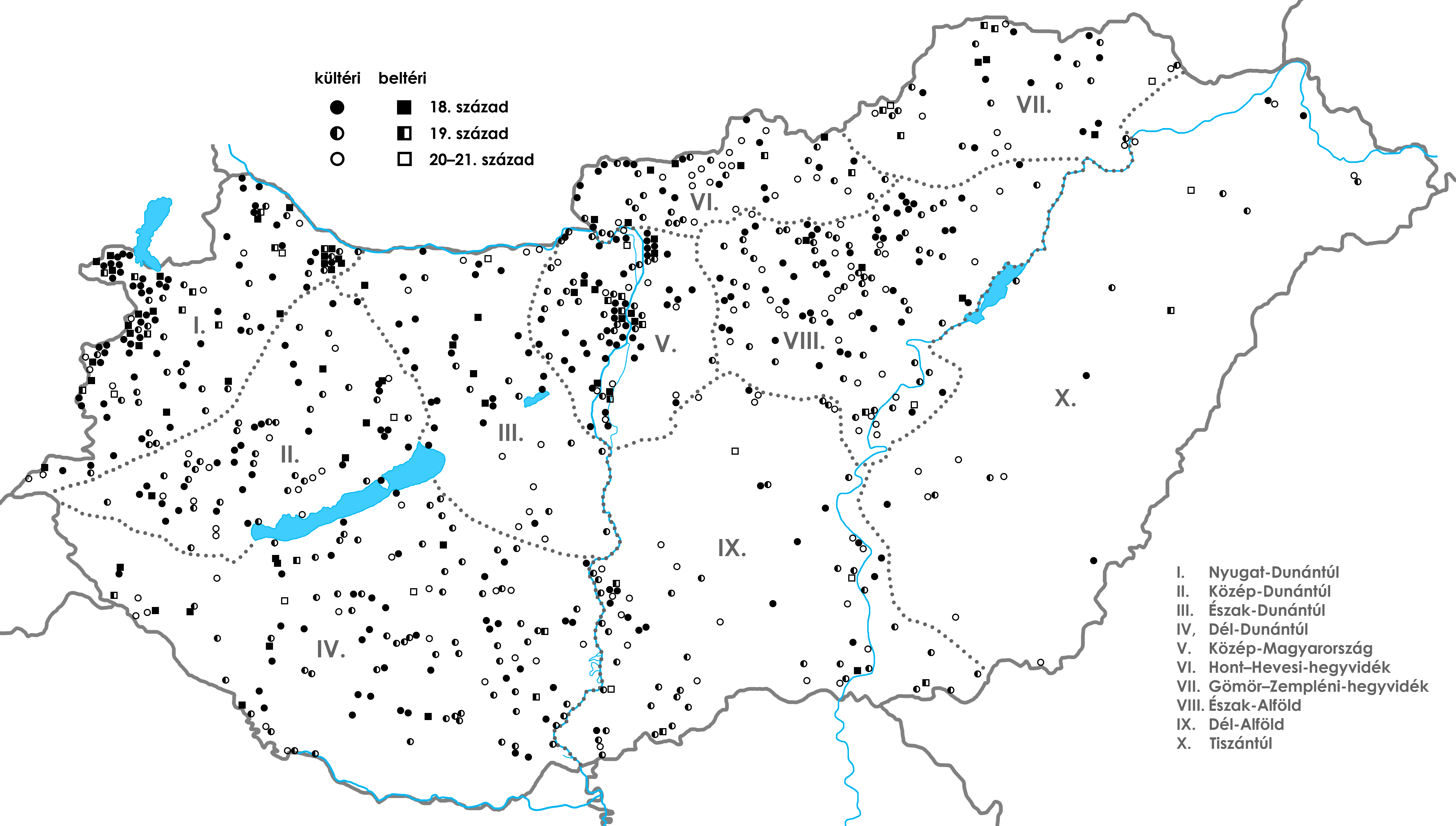
Map of the statues of Saint John of Nepomuk in Hungary
Summary
[edit]
| Description |
English: Map of the statues of Saint John of Nepomuk in Hungary
Magyar: Magyarországi Nepomuki Szent János-szobrok térképeA régiók meghatározásához a kultusznak a térképen kirajzolódó területeit különítettem el egymástól, vagyis nem követtem Kósa László vagy Borsos Balázs meglévő, néprajzi szempontú táji tagolásait. Nyugat-Dunántúl: a Rába-völgy az Alsó-Kemenesháttal és a Szigetközzel, valamint az ezektől nyugatra húzódó területek (6100 km²); Közép-Dunántúl: a Zalai-dombság északi része a Bakony-vidékkel (6700 km²); Észak-Dunántúl: a Duna-völgytől a Mezőföld déli pereméig, a Bakony-vidéktől a Keleti-Gerecséig és a Váli-víz síkjáig húzódó régió (6700 km²); Dél-Dunántúl: a Zala-völgytől, a Balaton-medencétől és a Mezőföldtől délre fekvő terület (15 500 km²); Közép-Magyarország: a Budapestet övező terület, nyugaton a Gerecse keleti vonulataiig és a Váli-völgyig, keleten a Pesti-hordalékkúpsíksággal, a Gödöllői-dombsággal és a Csepeli-síkkal (4500 km²); Hont–Hevesi-hegyvidék: az Észak-magyarországi-középhegység nyugati vonulatai a Pétervásárai-dombságig (3400 km²); Gömör–Zempléni-hegyvidék: az Észak-magyarországi-középhegység ettől keletre elterülő vidékei (5500 km²); Észak-Alföld: a Kiskunságtól északra fekvő Észak-alföldi-hordalékkúpsíkság és a Közép-Tisza-vidék, magában foglalva az északi peremvidék dombsági területeit, a Cserhátalját, a Mátraalját és az Egri-Bükkalját (8300 km²); Dél-Alföld: Duna–Tisza közi síkvidék és Alsó-Tisza-vidék (13 300 km²); Tiszántúl: a Közép- és Alsó-Tisza-vidék nélkül, de a Felső-Tisza-vidékkel (22 500 km²). |
| Date | |
| Source | Own work |
| Author | Pasztilla aka Attila Terbócs |
Licensing
[edit]
I, the copyright holder of this work, hereby publish it under the following license:
This file is licensed under the Creative Commons Attribution-Share Alike 4.0 International license.
- You are free:
- to share – to copy, distribute and transmit the work
- to remix – to adapt the work
- Under the following conditions:
- attribution – You must give appropriate credit, provide a link to the license, and indicate if changes were made. You may do so in any reasonable manner, but not in any way that suggests the licensor endorses you or your use.
- share alike – If you remix, transform, or build upon the material, you must distribute your contributions under the same or compatible license as the original.
File history
Click on a date/time to view the file as it appeared at that time.
| Date/Time | Thumbnail | Dimensions | User | Comment | |
|---|---|---|---|---|---|
| current | 09:08, 24 October 2022 | | 6,128 × 3,477 (1.01 MB) | Pasztilla (talk | contribs) | Adding newly discovered pinpoints: Ásványráró, Csombárd, Darnózseli, Dunaremete, Gyöngyös (Szent Orbán-templom), Győrzámoly, Lébény (templom és látogatóközpont), Mohora, Mosonmagyaróvár (Királydomb), Nagykanizsa (kőkereszt), Nagykónyi, Páka (templom), Sarud (templom), Somogyszentpál (templom), Szakcs, Szolnok (Vízügyi Emlékpark), Tarnaméra (templom), Vác (Tímár utca, Alsóvárosi temető) |
| 10:54, 15 April 2022 |  | 6,128 × 3,477 (1 MB) | Pasztilla (talk | contribs) | Uploaded own work with UploadWizard |
You cannot overwrite this file.
File usage on Commons
There are no pages that use this file.
File usage on other wikis
The following other wikis use this file:
- Usage on hu.wikipedia.org