File:Ltopo VI-17.jpg
Jump to navigation
Jump to search

Size of this preview: 606 × 599 pixels. Other resolutions: 243 × 240 pixels | 486 × 480 pixels | 777 × 768 pixels | 1,036 × 1,024 pixels | 2,071 × 2,048 pixels | 10,337 × 10,220 pixels.
Original file (10,337 × 10,220 pixels, file size: 16.19 MB, MIME type: image/jpeg)
Captions
Captions
Add a one-line explanation of what this file represents
| Карта западного пограничного пространства, 1 : 84 000 (Lithuanian part) | |||||||||||||
|---|---|---|---|---|---|---|---|---|---|---|---|---|---|
| VI-10 | VI-11 | VI-12 | VI-13 | VI-14 | VI-15 | VI-16 | VI-17 | VI-18 | |||||
| VII-9 | VII-10 | VII-11 | VII-12 | VII-13 | VII-14 | VII-15 | VII-16 | VII-17 | VII-18 | VII-19 | VII-20 | ||
| VIII-9 | VIII-10 | VIII-11 | VIII-12 | VIII-13 | VIII-14 | VIII-15 | VIII-16 | VIII-17 | VIII-18 | VIII-19 | VIII-20 | ||
| IX-10 | IX-11 | IX-12 | IX-13 | IX-14 | IX-15 | IX-16 | IX-17 | IX-18 | IX-19 | IX-20 | IX-21 | ||
| X-10 | X-11 | X-12 | X-13 | X-14 | X-15 | X-16 | X-17 | X-18 | X-19 | X-20 | X-21 | X-22 | |
| XI-12 | XI-13 | XI-14 | XI-15 | XI-16 | XI-17 | XI-18 | XI-19 | XI-20 | XI-21 | ||||
| XII-12 | XII-13 | XII-14 | XII-15 | XII-16 | XII-17 | XII-18 | XII-19 | XII-20 | |||||
| XIII-13 | XIII-14 | XIII-15 | XIII-16 | XIII-17 | XIII-18 | XIII-19 | |||||||
| XIV-13 | XIV-14 | XIV-15 | XIV-16 | XIV-17 | XIV-18 | XIV-19 | |||||||
| XV-14 | XV-15 | XV-16 | XV-17 | XV-18 | XV-19 | ||||||||
| XVI-14 | XVI-15 | XVI-16 | XVI-17 | ||||||||||
Summary
[edit]
| Warning | The original file is very high-resolution. It might not load properly or could cause your browser to freeze when opened at full size. |
|---|
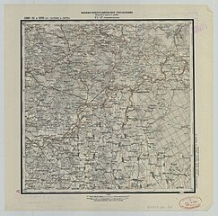
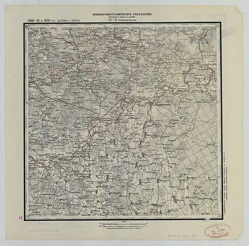
| Description | 2 verst map VI-17 | ||||
| Date | |||||
| Source | http://igrek.amzp.pl/mapindex.php?cat=R084 | ||||
| Author | Military topography department, Petrograd | ||||
| Permission (Reusing this file) |
|
||||
File history
Click on a date/time to view the file as it appeared at that time.
| Date/Time | Thumbnail | Dimensions | User | Comment | |
|---|---|---|---|---|---|
| current | 17:00, 8 September 2022 | | 10,337 × 10,220 (16.19 MB) | CD (talk | contribs) | {{LargeImage}} {{Information |Description=2 verst map VI-17 |Source=http://igrek.amzp.pl/mapindex.php?cat=R084 |Date=1930 |Author=Military topography department, Petrograd |Permission={{PD-old}} |other_versions= }} Category:Western borderspace map (2 versts per inch) |
You cannot overwrite this file.
File usage on Commons
There are no pages that use this file.