File:Lower course of Mimico Creek.jpg
Jump to navigation
Jump to search

Size of this preview: 620 × 600 pixels. Other resolutions: 248 × 240 pixels | 496 × 480 pixels | 794 × 768 pixels | 1,058 × 1,024 pixels | 2,069 × 2,002 pixels.
Original file (2,069 × 2,002 pixels, file size: 495 KB, MIME type: image/jpeg)
Captions
Captions
Add a one-line explanation of what this file represents
Summary
[edit]
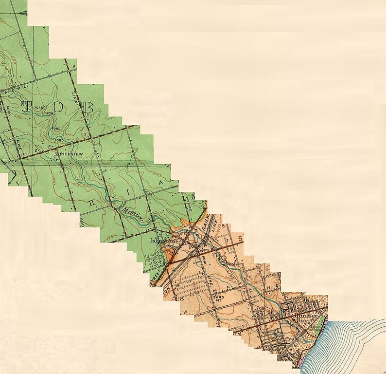
| Description | This map shows the approximate lower course of Mimico Creek, from northwest of the present day intersection of Eglington Avenue and Highway 427 to its mouth on Humber Bay. |
| Date | (UTC) |
| Source |
This file was derived from: The Pleistocene of the Toronto region.jpg: |
| Author |
|
| This is a retouched picture, which means that it has been digitally altered from its original version. Modifications: cropped. The original can be viewed here: The Pleistocene of the Toronto region.jpg:
|
Licensing
[edit]
This Canadian work is in the public domain in Canada because its copyright has expired due to one of the following:
it was not subject to Crown copyright, and
|
 |
Original upload log
[edit]
This image is a derivative work of the following images:
- File:The_Pleistocene_of_the_Toronto_region.jpg licensed with PD-Canada
- 2012-03-20T21:48:04Z Geo Swan 10205x8161 (14709288 Bytes) {{Information |Description=The Pleistocene of the Toronto region {{original caption|Title: The Pleistocene of the Toronto region: Including the Toronto interglacial formation Author: Coleman, A. P.; Province of Ontario: Depar
Uploaded with derivativeFX
File history
Click on a date/time to view the file as it appeared at that time.
| Date/Time | Thumbnail | Dimensions | User | Comment | |
|---|---|---|---|---|---|
| current | 21:51, 20 November 2012 | | 2,069 × 2,002 (495 KB) | Geo Swan (talk | contribs) | == {{int:filedesc}} == {{Information |Description=This map shows the approximate lower course of Mimico Creek, from northwest of the present day intersection of {{w|Eglington Avenue}} and {{w|Highway 427}} to its mouth on {{w|Humber Bay}}. |Source={{De... |
You cannot overwrite this file.
File usage on Commons
The following page uses this file: