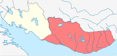
File:Location of Varzuga rural settlement (Tersky district).svg
From Wikimedia Commons, the free media repository
Jump to navigation
Jump to search

Size of this PNG preview of this SVG file: 394 × 188 pixels. Other resolutions: 320 × 153 pixels | 640 × 305 pixels | 1,024 × 489 pixels | 1,280 × 611 pixels | 2,560 × 1,222 pixels.
Original file (SVG file, nominally 394 × 188 pixels, file size: 178 KB)
File information
Structured data
Captions
Captions
Add a one-line explanation of what this file represents
| DescriptionLocation of Varzuga rural settlement (Tersky district).svg |
Русский: Карта расположения сельского поселения Варзуга |
| Date | (UTC) |
| Source | |
| Author |
|
| This is a retouched picture, which means that it has been digitally altered from its original version. Modifications: Crop, change color. The original can be viewed here: Location of Tersky district (Murmansk Oblast).svg:
|
This file is licensed under the Creative Commons Attribution-Share Alike 3.0 Unported license.
- You are free:
- to share – to copy, distribute and transmit the work
- to remix – to adapt the work
- Under the following conditions:
- attribution – You must give appropriate credit, provide a link to the license, and indicate if changes were made. You may do so in any reasonable manner, but not in any way that suggests the licensor endorses you or your use.
- share alike – If you remix, transform, or build upon the material, you must distribute your contributions under the same or compatible license as the original.
Original upload log
[edit]This image is a derivative work of the following images:
- File:Location_of_Tersky_district_(Murmansk_Oblast).svg licensed with Cc-by-sa-3.0, GFDL
- 2011-02-08T01:32:19Z Insider 720x548 (2150933 Bytes) На всех картах исправлено цветовое оформление Карелии и Архангельской области; не на всех картах исправлена окраска остро
- 2011-02-07T17:38:45Z Das steinerne Herz 720x548 (2150864 Bytes) {{Information |Description={{ru|1=Позиционная карта Терский муниципальный район Мурманской области *Проекция — равноугольная. *Стандарт�
Uploaded with derivativeFX
File history
Click on a date/time to view the file as it appeared at that time.
| Date/Time | Thumbnail | Dimensions | User | Comment | |
|---|---|---|---|---|---|
| current | 23:08, 8 February 2011 |  | 394 × 188 (178 KB) | Insider (talk | contribs) | {{Information |Description={{ru|1=Карта расположения сельского поселения Варзуга}} |Source=*File:Location_of_Tersky_district_(Murmansk_Oblast).svg |Date=2011-02-08 23:06 (UTC) |Author=*[[:File:Location_of_Te |
You cannot overwrite this file.
File usage on Commons
There are no pages that use this file.
File usage on other wikis
The following other wikis use this file:
- Usage on fr.wikipedia.org
- Usage on ru.wikipedia.org
- Usage on uk.wikipedia.org