File:LocationCrimea 5.png
Jump to navigation
Jump to search

Size of this preview: 720 × 600 pixels. Other resolutions: 288 × 240 pixels | 576 × 480 pixels | 922 × 768 pixels | 1,200 × 1,000 pixels.
Original file (1,200 × 1,000 pixels, file size: 50 KB, MIME type: image/png)
Captions
Captions
Add a one-line explanation of what this file represents
Summary
[edit]
| Description |
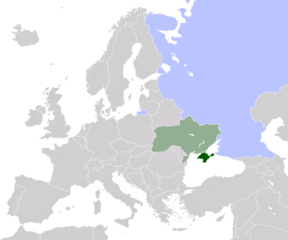
English: map of Europe, highlighted Ukraine with Crimea, and Russia |
| Date | |
| Source |
This file was derived from: LocationCrimea.PNG: |
| Author |
|
| Other versions |
   .PNG) |
Licensing
[edit]
This work is based on a work in the public domain. It has been digitally enhanced and/or modified. This derivative work has been (or is hereby) released into the public domain by its author, CoArms. This applies worldwide.
In some countries this may not be legally possible; if so: |
File history
Click on a date/time to view the file as it appeared at that time.
| Date/Time | Thumbnail | Dimensions | User | Comment | |
|---|---|---|---|---|---|
| current | 13:27, 20 March 2014 | | 1,200 × 1,000 (50 KB) | FeyBart (talk | contribs) | User created page with UploadWizard |
You cannot overwrite this file.
File usage on Commons
The following 4 pages use this file:
File usage on other wikis
The following other wikis use this file:
- Usage on la.wikipedia.org
- Usage on nl.wikipedia.org