File:Linschoten map.jpg

Original file (889 × 762 pixels, file size: 272 KB, MIME type: image/jpeg)
Captions
Captions
Info
[edit]| DescriptionLinschoten map.jpg |
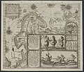
English: A low quality version of the Linschoten map of Scandinavia. Use other versions. |
|||||
| Date | Drafted 1590s, engraved 1599, printed 1599 or 1601 | |||||
| Source | A version—dated 1601 and placed at Franeker for no apparent reason—of a map originally printed for inclusion in the 1599 Latin version of Jan Huyghen van Linschoten's Itinerario (at the Hague by Albert Henri de Sallengre as "Alberti Henrici"), which included Linschoten's translation of Gerrit de Veer's journal of Willem Barentsz's voyages to the north in the 1590s, which Linschoten also took part in. | |||||
| Author | Joannes van Doetecum and Baptista van Doetecum | |||||
| Permission (Reusing this file) |
|
|||||
| Other versions |
|
|||||
| Annotations InfoField | This image is annotated: View the annotations at Commons |
Ioan. a Doet.
Bapt. a D. fec.
Joan[nes] van Doet[ecum &]
Bapt[ista] van D[oetecum] mad[e this].
Duytsche mylen 15. in een graedt
Dutch Mijls 15 in One Degree
Waerachtige verthooninge end gelegentheyt van de Custen, streckingen ende coursen, van Hollant af, be Noorden om door d'Enckte van Nassau, tot voorby de Revier Oby gelyck als het alles geannoteert ende bevaren is geweest, door Jan Huygen van Linschoten de jaren van 1594, ende 1595, etc.
Prudentissimo et solertissimo Viro D. Balthasaro Moucheron, olim apud Antwerpianos civum praefecto amico et patrono L.M.D.D. Ioannes Hugo a Linschoten. 1599.
Der Samoieden afgoden.
Samoetarum qui cis et trans fretum Nassouviae omnem eam orbis Septentrionalis tractum incolunt qua a flum: Pitzora ad flumen usque Oby protenditur facies habitus et trahe quibus addito rangifero quod mirae celebritatis animal est utuntur tra[n]smittendo itineri, et simulachra quorum e ligno magna illi passim est copia retecta et prodita a Ioannes Hugo. Linschotio priori navigatione Anno 1594.
Waerachtige afbeeldinge ende gedaente der Samoieden, de haer onthoudende zyn op Nova Zembla, Vaygatz, en p lant van by zuyden de Enckte van Nassau, te weten van Pitzora af tot voorby de Revier Oby, en soo gelyck als de selfde rydende zyn, met haere sleeckens ende ingespannen tamme Rheenen, mitsgaders de gedaente haerder afgoden often houten beelden, soo alsse op veel hoecken en clippen, by menichte stonden, gelyck als sulcks alles ondeckt ende sichtelycken d'eerste reyse ondervonden is door Jan Huygen van Linschoten int Iaer 1594.
File history
Click on a date/time to view the file as it appeared at that time.
| Date/Time | Thumbnail | Dimensions | User | Comment | |
|---|---|---|---|---|---|
| current | 08:37, 4 December 2007 |  | 889 × 762 (272 KB) | Sherurcij (talk | contribs) | {{Information |Description=Map of Barents' voyages |Source=Journal of Jan Huyghens van Linschoten |Date=1601 |Author= Jan Huyghens van Linschoten |Permission={{PD-old}} |other_versions= }} Category:Maps |
| 08:33, 4 December 2007 |  | 576 × 499 (119 KB) | Sherurcij (talk | contribs) | {{Information |Description=Map of Barents' voyages |Source=Journal of Jan Huyghens van Linschoten |Date=1601 |Author= Jan Huyghens van Linschoten |Permission={{PD-old}} |other_versions= }} Category:Maps |
You cannot overwrite this file.
File usage on Commons
The following 4 pages use this file:
Metadata
This file contains additional information such as Exif metadata which may have been added by the digital camera, scanner, or software program used to create or digitize it. If the file has been modified from its original state, some details such as the timestamp may not fully reflect those of the original file. The timestamp is only as accurate as the clock in the camera, and it may be completely wrong.
| _error | 0 |
|---|


