File:Lickey incline.jpg
Jump to navigation
Jump to search
No higher resolution available.
Lickey_incline.jpg (640 × 480 pixels, file size: 59 KB, MIME type: image/jpeg)
Captions
Captions
Add a one-line explanation of what this file represents
| Description |
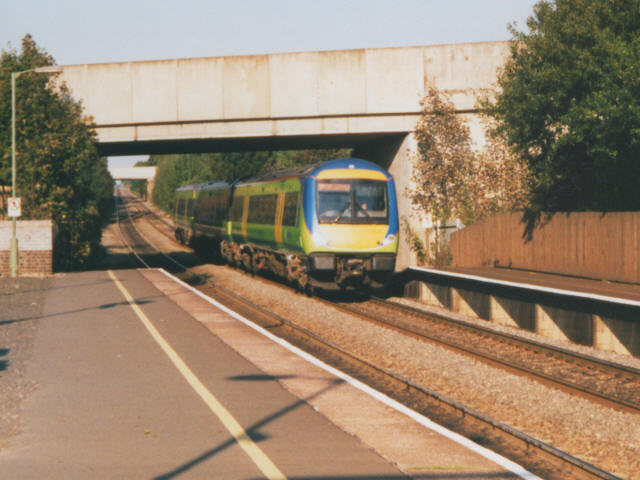
English: Looking up Lickey Incline
The long incline north-east of Bromsgrove station is among the steepest on any main line railway in the UK and was feared by drivers in steam days, but is no hazard for modern diesels. |
| Date | |
| Source | From geograph.org.uk |
| Author | Stephen Craven |
| Permission (Reusing this file) |
Creative Commons Attribution Share-alike license 2.0 |
| Attribution (required by the license) | Stephen Craven / Looking up Lickey Incline / |
| Camera location | | View this and other nearby images on: OpenStreetMap |
|---|

|
This image was taken from the Geograph project collection. See this photograph's page on the Geograph website for the photographer's contact details. The copyright on this image is owned by Stephen Craven and is licensed for reuse under the Creative Commons Attribution-ShareAlike 2.0 license.
|
This file is licensed under the Creative Commons Attribution-Share Alike 2.0 Generic license.
Attribution: Stephen Craven
- You are free:
- to share – to copy, distribute and transmit the work
- to remix – to adapt the work
- Under the following conditions:
- attribution – You must give appropriate credit, provide a link to the license, and indicate if changes were made. You may do so in any reasonable manner, but not in any way that suggests the licensor endorses you or your use.
- share alike – If you remix, transform, or build upon the material, you must distribute your contributions under the same or compatible license as the original.
Original upload log
[edit]
The original description page was here. All following user names refer to en.wikipedia.
- 2007-03-10 15:18 T.roome 640×480× (60303 bytes) Author Steven Craven found on www.geograph.org.uk link to photo. https://www.geograph.org.uk/photo/222761
File history
Click on a date/time to view the file as it appeared at that time.
| Date/Time | Thumbnail | Dimensions | User | Comment | |
|---|---|---|---|---|---|
| current | 14:26, 20 October 2008 | | 640 × 480 (59 KB) | Angusmclellan (talk | contribs) | {{Information |Description={{en|Looking up Lickey Incline The long incline north-east of Bromsgrove station is among the steepest on any main line railway in the UK and was feared by drivers in steam days, but is no hazard for modern diesels. }} |Source=F |
You cannot overwrite this file.
File usage on Commons
The following page uses this file:
File usage on other wikis
The following other wikis use this file:
- Usage on arz.wikipedia.org
- Usage on azb.wikipedia.org
- Usage on en.wikipedia.org
- Usage on en.wikivoyage.org
- Usage on nl.wikipedia.org
- Usage on simple.wikipedia.org
- Usage on www.wikidata.org
- Usage on zh.wikipedia.org
Metadata
Categories:
- Bromsgrove railway station (1840-2016)
- Lickey Incline
- British Rail Class 170s of Central Trains
- British Rail Class 170s in Central Trains livery
- British Rail Class 170s on the Cross Country Route
- October 2003 in Worcestershire
- October 2003 in rail transport in England
- October 2003 in rail transport in the United Kingdom