File:Lewes Racecourse - geograph.org.uk - 71560.jpg
Jump to navigation
Jump to search
No higher resolution available.
Lewes_Racecourse_-_geograph.org.uk_-_71560.jpg (640 × 479 pixels, file size: 185 KB, MIME type: image/jpeg)
Captions
Captions
Add a one-line explanation of what this file represents
Summary
[edit]
| Description |
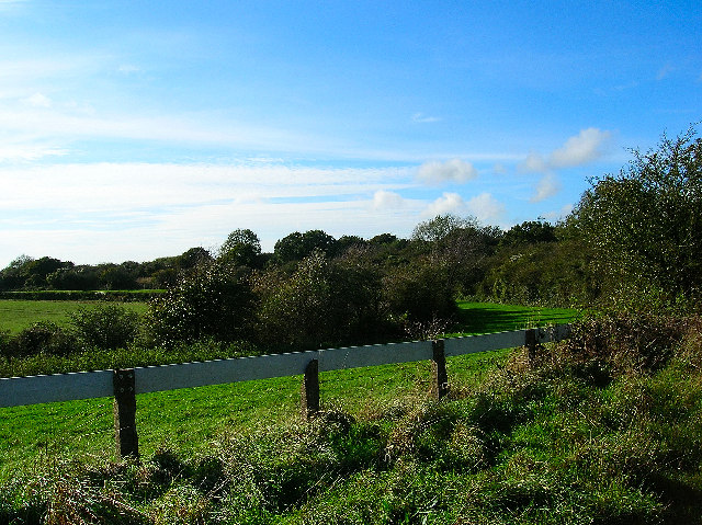
English: Lewes Racecourse. Like Brighton the track at Lewes follows the ridge of the Downs and is not circuit. Lewes first hosted racing in the 18th century and for two hundred years eked out a living, however, in 1963 the British Racing Board decided that it would no longer finance the course (along with five others). The management struggled on for another year until throwing in the towel in September 1964. Crowds had dwindled due to difficult access to the course and being prey to the elements to the point where takings rarely covered prize money. The track is still there but nowadays used as training gallops. This picture was taken in the U near the top of the course and looks south west. |
| Date | |
| Source | From geograph.org.uk |
| Author | Simon Carey |
| Attribution (required by the license) | Simon Carey / Lewes Racecourse / |
| Camera location | | View this and other nearby images on: OpenStreetMap |
|---|
_&language=en)
| Object location | | View this and other nearby images on: OpenStreetMap |
|---|
_&language=en)
Licensing
[edit]

|
This image was taken from the Geograph project collection. See this photograph's page on the Geograph website for the photographer's contact details. The copyright on this image is owned by Simon Carey and is licensed for reuse under the Creative Commons Attribution-ShareAlike 2.0 license.
|
This file is licensed under the Creative Commons Attribution-Share Alike 2.0 Generic license.
Attribution: Simon Carey
- You are free:
- to share – to copy, distribute and transmit the work
- to remix – to adapt the work
- Under the following conditions:
- attribution – You must give appropriate credit, provide a link to the license, and indicate if changes were made. You may do so in any reasonable manner, but not in any way that suggests the licensor endorses you or your use.
- share alike – If you remix, transform, or build upon the material, you must distribute your contributions under the same or compatible license as the original.
- Remove redundant categories and try to put this image in the most specific category/categories
- Remove this template
- The location categories are based on information from this geonames tool and this OpenStreetMap tool combined with a database. You can also have a look at this tool from mysociety.
- The topic category from Geograph was Gallops (find similar images at Geograph)
File history
Click on a date/time to view the file as it appeared at that time.
| Date/Time | Thumbnail | Dimensions | User | Comment | |
|---|---|---|---|---|---|
| current | 16:42, 30 January 2010 | | 640 × 479 (185 KB) | GeographBot (talk | contribs) | == {{int:filedesc}} == {{Information |description={{en|1=Lewes Racecourse. Like Brighton the track at Lewes follows the ridge of the Downs and is not circuit. Lewes first hosted racing in the 18th century and for two hundred years eked out a living, howev |
You cannot overwrite this file.
File usage on Commons
There are no pages that use this file.
File usage on other wikis
The following other wikis use this file:
- Usage on en.wikipedia.org
- Usage on www.wikidata.org