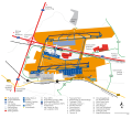
File:Leipzig-Halle Airport General plan.svg
From Wikimedia Commons, the free media repository
Jump to navigation
Jump to search

Size of this PNG preview of this SVG file: 587 × 599 pixels. Other resolutions: 235 × 240 pixels | 470 × 480 pixels | 752 × 768 pixels | 1,003 × 1,024 pixels | 2,006 × 2,048 pixels | 1,498 × 1,529 pixels.
Original file (SVG file, nominally 1,498 × 1,529 pixels, file size: 671 KB)
File information
Structured data
Captions
Captions
Add a one-line explanation of what this file represents
Summary
[edit]| DescriptionLeipzig-Halle Airport General plan.svg |
English: Leipzig/Halle Airport, general plan
Deutsch: Flughafen Leipzig/Halle, Übersichtsplan |
| Date | |
| Source | Own work |
| Author | Lumu |
| SVG development InfoField |
gestaltet nach:
- Staatsbetrieb Geobasisinformation und Vermessung Sachsen (GeoSN): Luftbild (http://www.landesvermessung.sachsen.de/ias/basiskarte4/service/register)
- Mitteldeutsche Airport Holding: Zwei Portale zu einer dynamischen Region, Ausgabe 2008, S. 17
- Leipzig/Halle Airport: Verkehrsregeln für den nicht öffentlichen Bereich des Flughafengeländes der Flughafen Leipzig/Halle GmbH (FLHG), Ausgabe vom 3. April 2012, Anlagen B und C
Schriftart: Computer Modern CMU Sans Serif
Licensing
[edit]
|
Permission is granted to copy, distribute and/or modify this document under the terms of the GNU Free Documentation License, Version 1.2 or any later version published by the Free Software Foundation; with no Invariant Sections, no Front-Cover Texts, and no Back-Cover Texts. A copy of the license is included in the section entitled GNU Free Documentation License.http://www.gnu.org/copyleft/fdl.htmlGFDLGNU Free Documentation Licensetruetrue |
| This file is licensed under the Creative Commons Attribution-Share Alike 3.0 Unported license. | ||
| ||
| This licensing tag was added to this file as part of the GFDL licensing update.http://creativecommons.org/licenses/by-sa/3.0/CC BY-SA 3.0Creative Commons Attribution-Share Alike 3.0truetrue |
File history
Click on a date/time to view the file as it appeared at that time.
| Date/Time | Thumbnail | Dimensions | User | Comment | |
|---|---|---|---|---|---|
| current | 22:46, 25 November 2012 |  | 1,498 × 1,529 (671 KB) | Lumu (talk | contribs) | Check-in-Symbol repariert |
| 00:57, 25 November 2012 |  | 1,498 × 1,529 (654 KB) | Lumu (talk | contribs) | kleine Korrektur | |
| 00:25, 25 November 2012 |  | 1,498 × 1,529 (655 KB) | Lumu (talk | contribs) | Begrenzung so eindeutiger | |
| 23:47, 24 November 2012 |  | 1,498 × 1,529 (653 KB) | Lumu (talk | contribs) | Rollfeld–Zuständigkeit DFS | |
| 00:21, 24 November 2012 |  | 1,498 × 1,529 (648 KB) | Lumu (talk | contribs) | auf aktuellen Stand gebracht (Apron 3, Erweiterung Apron 4), Ortslage Glesien eingez. | |
| 14:25, 17 May 2010 |  | 1,498 × 1,424 (393 KB) | Lumu (talk | contribs) | überflüssigen jpg-Verweis entfernt | |
| 14:13, 17 May 2010 |  | 1,498 × 1,424 (398 KB) | Lumu (talk | contribs) | *Verlegung S8 mit Brücke über A14 *Feuerwachen Ost u. West *Neubau zweite Rollbrücke Ost *Triebwerksprobelaufhalle *altes Abfertigungsgebäude von 1937 *Lärmschutzwall *kleine Korrekturen | |
| 18:30, 15 July 2009 |  | 1,552 × 1,378 (585 KB) | Lumu (talk | contribs) | Grenzen korrigiert; Firma heisst TFSS | |
| 20:59, 18 June 2009 |  | 1,552 × 1,378 (584 KB) | Lumu (talk | contribs) | rote Linie entfernt | |
| 20:42, 18 June 2009 |  | 1,552 × 1,378 (584 KB) | Lumu (talk | contribs) | Überarbeitung (Flächen berichtigt, alter Verlauf Südbahn, Aprons, Parkpositionen, BAB-Anschlussstelle, Legende) |
You cannot overwrite this file.
File usage on Commons
There are no pages that use this file.
File usage on other wikis
The following other wikis use this file:
- Usage on ast.wikipedia.org
- Usage on de.wikipedia.org
- Usage on en.wikipedia.org
- Usage on es.wikipedia.org
- Usage on fr.wikipedia.org
- Usage on id.wikipedia.org
- Usage on it.wikipedia.org
- Usage on ja.wikipedia.org
- Usage on ko.wikipedia.org
- Usage on mk.wikipedia.org
- Usage on ru.wikipedia.org
- Usage on www.wikidata.org
- Usage on zh.wikipedia.org
Metadata
This file contains additional information such as Exif metadata which may have been added by the digital camera, scanner, or software program used to create or digitize it. If the file has been modified from its original state, some details such as the timestamp may not fully reflect those of the original file. The timestamp is only as accurate as the clock in the camera, and it may be completely wrong.
| Width | 1498.337px |
|---|---|
| Height | 1529.228px |