File:Lee Makes Landfall in Nova Scotia (MODIS).jpg
Original file (6,617 × 4,990 pixels, file size: 4.03 MB, MIME type: image/jpeg)
Captions
Captions
Summary
[edit].jpg&action=edit§ion=1)
| Description |
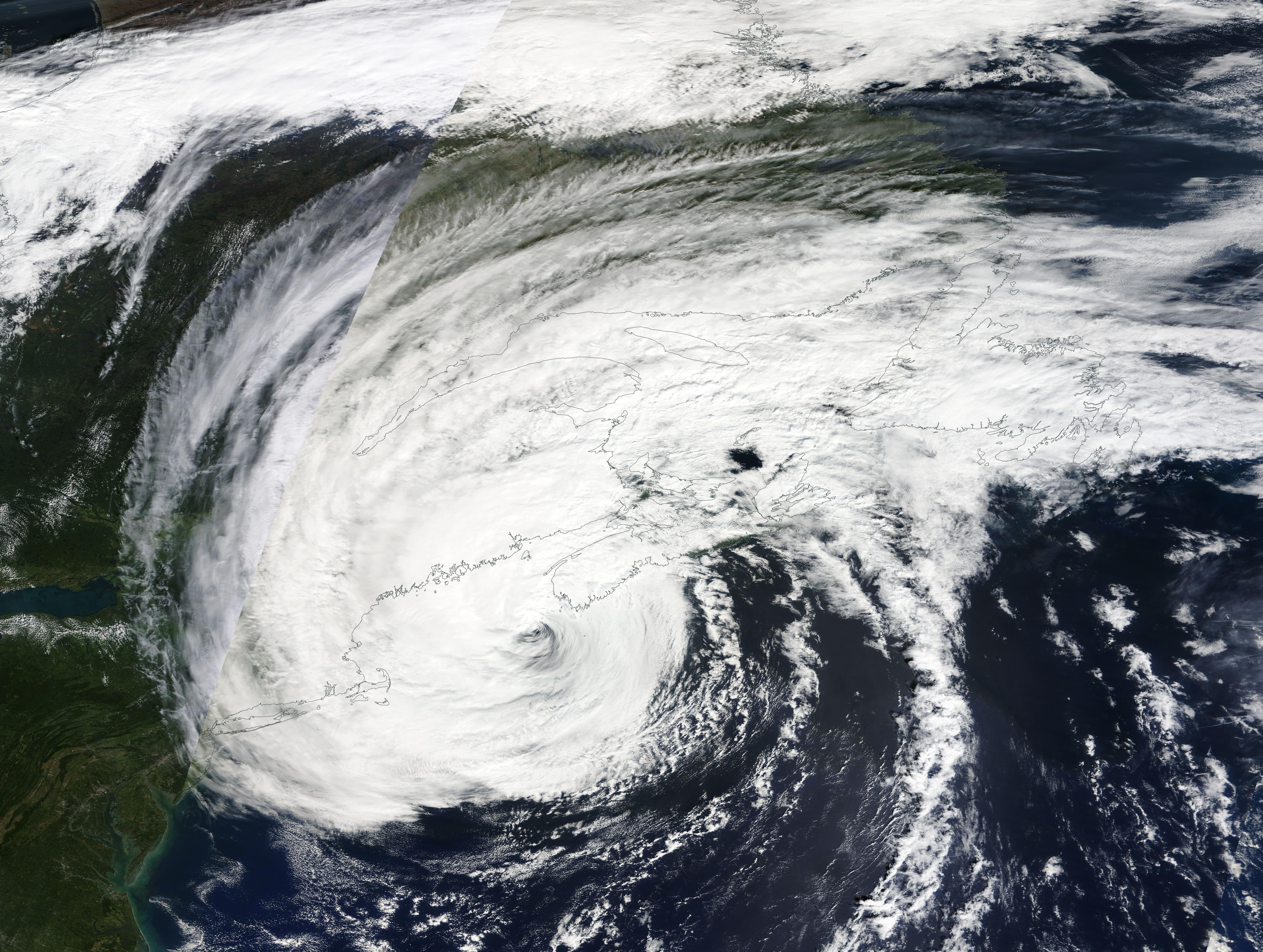
English: Once a Category 5 hurricane, carrying maximum sustained winds of 165 mph (265.5 km/h), Lee had become a relatively docile post-tropical cyclone when it made landfall on Long Island, Nova Scotia, Canada at about 4:00 p.m. EST (2000 UTC) on September 16. But it still packed a giant punch to parts of Maritime Canada and U.S. New England.
According to the National Hurricane Center (NHC), maximum sustained winds at landfall were estimated at 70 mph (110 km/h). However, Lee remained at Category-1-hurricane strength until just a few hours before landfall. At 8:00 am EDT (1200 UTC) on September 16, near the time the that the Moderate Resolution Imaging Spectroradiometer (MODIS) on NASA’s Terra satellite acquired this true-color image, the NHC estimated Lee’s maximum sustained winds at 80 mph (129 km/h). Hurricane-force winds extended as far as 140 miles (220 km) from Lee’s center and tropical-storm-force winds extending 390 miles (630 km) from center—an area that covered all of Maine, parts of New Hampshire, as well as much of Maritime Canada. As Post-Tropical Cyclone Lee approached landfall, it ducked into the Bay of Fundy to travel between mainland Nova Scotia and eastern Maine, coming within 50 miles (80 km) of Eastport, Maine. The storm downed trees, took out power, and caused substantial damage across its path in Maritime Canada, as well as the side-swiped area of New England. According to News Center Maine, at midday on September 16, 11% of electricity customers in Maine lacked power, along with 27% of Nova Scotia, 8% of New Brunswick and 3% of Prince Edward Island. A Canadian news company, CBC, also reported that on September 17, more than 23,400 people remained without power in Nova Scotia. |
||
| Date | Taken on 16 September 2023 | ||
| Source |
Lee Makes Landfall in Nova Scotia (direct link)
|
||
| Author | MODIS Land Rapid Response Team, NASA GSFC |
| This media is a product of the Terra mission Credit and attribution belongs to the mission team, if not already specified in the "author" row |
Licensing
[edit].jpg&action=edit§ion=2)
| This file is in the public domain in the United States because it was solely created by NASA. NASA copyright policy states that "NASA material is not protected by copyright unless noted". (See Template:PD-USGov, NASA copyright policy page or JPL Image Use Policy.) | ||
 |
Warnings:
|
File history
Click on a date/time to view the file as it appeared at that time.
| Date/Time | Thumbnail | Dimensions | User | Comment | |
|---|---|---|---|---|---|
| current | 05:05, 19 September 2023 | | 6,617 × 4,990 (4.03 MB) | OptimusPrimeBot (talk | contribs) | #Spacemedia - Upload of http://modis.gsfc.nasa.gov/gallery/images/image09192023_500m.jpg via Commons:Spacemedia |
You cannot overwrite this file.
File usage on Commons
There are no pages that use this file.
.jpg&oldid=909384965)