File:Lascar Checkpoint Charlie (4472530876).jpg
Jump to navigation
Jump to search

Size of this preview: 800 × 531 pixels. Other resolutions: 320 × 213 pixels | 640 × 425 pixels | 1,024 × 680 pixels | 1,280 × 850 pixels | 2,560 × 1,700 pixels | 3,216 × 2,136 pixels.
Original file (3,216 × 2,136 pixels, file size: 1.77 MB, MIME type: image/jpeg)
Captions
Captions
Add a one-line explanation of what this file represents
Summary
[edit].jpg&action=edit§ion=1)
| Description |
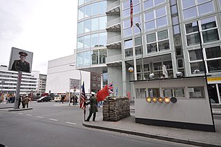
English: Checkpoint Charlie "Checkpoint C" was the name given by the Western Allies to a crossing point between East Berlin and West Berlin during the Cold War, located at the junction of Friedrichstraße with Zimmerstraße and Mauerstraße, (which for older historical reasons coincidentally means 'Wall Street'). It is in the Friedrichstadt neighborhood, which was divided by the Berlin Wall. Many other sector crossing points existed in Berlin. Some of these were designated for residents of West Berlin and West German citizens. Checkpoint Charlie was designated as the single crossing point (by foot or by car) for foreigners and members of the Allied forces. (Members of the Allied forces were not allowed to use the other sector crossing point designated for use by foreigners, the Friedrichstraße railway station). The name Charlie came for the letter C in the NATO phonetic alphabet; similarly for other Allied checkpoints on the Autobahn from the West: Checkpoint Alpha at Helmstedt and its counterpart Checkpoint Bravo at Dreilinden, Wannsee in the south-west corner of Berlin. The Soviets simply called it the Friedrichstraße Crossing Point (КПП Фридрихштрассе) . The East Germans officially referred to Checkpoint Charlie as the Grenzübergangsstelle ("Border Crossing Point") Friedrich-/Zimmerstraße. A view of Checkpoint Charlie in 1977, from the American sector Checkpoint Charlie became a symbol of the Cold War, representing the separation of east and west, and — for some East Germans — a gateway to freedom. It is frequently featured in spy movies and books, such as those by John le Carré. The famous cafe and viewing point for Allied officials, Armed Forces and visitors alike, Cafe Adler ("Cafe Eagle"), is situated right on the checkpoint. It was an excellent viewing point to look into East Berlin, while having something to eat and drink. Allied Checkpoint Charlie. The Allied checkpoint as viewed from the GDR checkpoint (June 1986) The checkpoint was curiously asymmetrical. During its 28-year active life, the infrastructure on the Eastern side was expanded to include not only the wall, watchtower and zig-zag barriers, but a multi-lane shed where cars and their occupants were checked. However the Allied authority never erected any permanent buildings, and made do with the iconic wooden shed, which was replaced in the 1980s by a larger metal structure now on display at the Allied Museum in western Berlin. Their reason was that they did not consider the inner Berlin sector boundary an international border and did not treat it as such. In the years after reunification, a reproduction of the 1960s-era wooden shed was placed at the site of the original [Wikipedia.org] |
| Date | |
| Source | Checkpoint Charlie |
| Author | Jorge Láscar from Australia |
| Camera location | | View this and other nearby images on: OpenStreetMap |
|---|
.jpg¶ms=052.507487_N_0013.390059_E_globe:Earth_type:camera_source:Flickr_&language=en)
Licensing
[edit].jpg&action=edit§ion=2)
This file is licensed under the Creative Commons Attribution 2.0 Generic license.
- You are free:
- to share – to copy, distribute and transmit the work
- to remix – to adapt the work
- Under the following conditions:
- attribution – You must give appropriate credit, provide a link to the license, and indicate if changes were made. You may do so in any reasonable manner, but not in any way that suggests the licensor endorses you or your use.
| This image was originally posted to Flickr by Jorge Lascar at https://www.flickr.com/photos/8721758@N06/4472530876. It was reviewed on 2 April 2014 by FlickreviewR and was confirmed to be licensed under the terms of the cc-by-2.0. |
File history
Click on a date/time to view the file as it appeared at that time.
| Date/Time | Thumbnail | Dimensions | User | Comment | |
|---|---|---|---|---|---|
| current | 09:25, 2 April 2014 | | 3,216 × 2,136 (1.77 MB) | Russavia (talk | contribs) | Transferred from Flickr |
You cannot overwrite this file.
File usage on Commons
There are no pages that use this file.
.jpg&oldid=899966865)