File:Lagrandeencyclopedie.1890.jpg
Jump to navigation
Jump to search

Size of this preview: 307 × 600 pixels. Other resolutions: 123 × 240 pixels | 246 × 480 pixels | 1,000 × 1,953 pixels.
Original file (1,000 × 1,953 pixels, file size: 426 KB, MIME type: image/jpeg)
Captions
Captions
Add a one-line explanation of what this file represents
| Description |
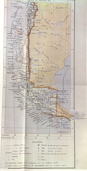
This map, partially reproduced here, is included in the part corresponding to Chile in "La Grande Encyclopedie" published in paris 1888-1890. Both in the part corresponding to Chile and in the map illustrating the article, the boundaries of the Treaty between Chile and Argentina of 1881 are correctly drawn. Thus in the extreme southern region the international boundary is traced along the centre of the Beagle Channel to beyond its eastern mouth, indicating Picton, Nueva and Lennox Islands and all the other islands and islets extending southward as far as Cape Horn as under Chilean sovereignty |
||||
| Date | |||||
| Source | Relaciones Chileno-Argentinas, La controversia del Beagle, edited by chilean Foreign Affairs, Geneve, Switzerland, 1979 | ||||
| Author | "La Grande Encyclopedie" | ||||
| Permission (Reusing this file) |
|
||||
File history
Click on a date/time to view the file as it appeared at that time.
| Date/Time | Thumbnail | Dimensions | User | Comment | |
|---|---|---|---|---|---|
| current | 22:28, 11 January 2008 | | 1,000 × 1,953 (426 KB) | Keysanger (talk | contribs) | {{Information |Description=This map, partially reproduced here, is included in the part corresponding to Chile in "La Grande Encyclopedie" published in paris 1888-1890. Both in the part corresponding to Chile and in the map illustrating the article, the b |
You cannot overwrite this file.
File usage on Commons
There are no pages that use this file.