File:Ladron Peak, New Mexico (2911761437).jpg

Original file (1,280 × 960 pixels, file size: 132 KB, MIME type: image/jpeg)
Captions
Captions
Summary
[edit]| DescriptionLadron Peak, New Mexico (2911761437).jpg |
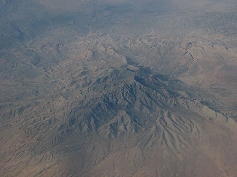
Ladrón Peak is an isolated, highly visible peak in central New Mexico, lying about 50 mi (80 km) southwest of Albuquerque. Ladron Peak is the only major peak in the compact range (really one large massif) known as the Sierra Ladrones, which lies between the Rio Puerco to the east and the Rio Salado to the southwest. Despite its conical shape and its proximity to lava flows and small volcanoes, it is not itself a volcano. The core of the mountain is Precambrian granite. The peak does rise dramatically from its surroundings on all sides; the summit is almost 4,500 ft (1,350 m) above the Rio Grande Valley, 10 miles to the east. The name of the peak means "thief", and "Sierra Ladrones" means "thieves' mountains." Navajo and Apache raiding parties, and later Hispanic and Anglo rustlers, used the mountains as hideouts, hence the name. Evidence of human occupation goes back over 10,000 years, and more recent prehistoric use occurred by the Mogollon and Anasazi cultures. Today, part of the range is included in the Sevilleta National Wildlife Refuge, administered by the US Fish and Wildlife Service. The rest of the range is a mix of BLM and private land. Ecologically, Ladrón Peak is a sky island, supporting vegetation and wildlife not found in the surrounding grasslands. It is high enough to have coniferous forests on its upper slopes. Animal species include mountain lion, bear, pronghorn, raptors, and reintroduced desert bighorn sheep. en.wikipedia.org/wiki/Ladron_Peak en.wikipedia.org/wiki/Wikipedia:Text_of_Creative_Commons_... |
| Date | |
| Source | Ladron Peak, New Mexico |
| Author | Ken Lund from Reno, Nevada, USA |
| Camera location | 34° 26′ 05.81″ N, 107° 05′ 07.34″ W | View this and other nearby images on: OpenStreetMap |
|---|
Licensing
[edit]- You are free:
- to share – to copy, distribute and transmit the work
- to remix – to adapt the work
- Under the following conditions:
- attribution – You must give appropriate credit, provide a link to the license, and indicate if changes were made. You may do so in any reasonable manner, but not in any way that suggests the licensor endorses you or your use.
- share alike – If you remix, transform, or build upon the material, you must distribute your contributions under the same or compatible license as the original.
| This image was originally posted to Flickr by Ken Lund at https://flickr.com/photos/75683070@N00/2911761437. It was reviewed on 3 December 2015 by FlickreviewR and was confirmed to be licensed under the terms of the cc-by-sa-2.0. |
3 December 2015
File history
Click on a date/time to view the file as it appeared at that time.
| Date/Time | Thumbnail | Dimensions | User | Comment | |
|---|---|---|---|---|---|
| current | 22:00, 3 December 2015 |  | 1,280 × 960 (132 KB) | INeverCry (talk | contribs) | Transferred from Flickr via Flickr2Commons |
You cannot overwrite this file.
File usage on Commons
There are no pages that use this file.
Metadata
This file contains additional information such as Exif metadata which may have been added by the digital camera, scanner, or software program used to create or digitize it. If the file has been modified from its original state, some details such as the timestamp may not fully reflect those of the original file. The timestamp is only as accurate as the clock in the camera, and it may be completely wrong.
| Camera manufacturer | Canon |
|---|---|
| Camera model | Canon PowerShot A540 |
| Exposure time | 1/640 sec (0.0015625) |
| F-number | f/4 |
| Date and time of data generation | 07:51, 24 July 2008 |
| Lens focal length | 11.759 mm |
| Orientation | Normal |
| Horizontal resolution | 180 dpi |
| Vertical resolution | 180 dpi |
| File change date and time | 07:51, 24 July 2008 |
| Y and C positioning | Centered |
| Exif version | 2.2 |
| Date and time of digitizing | 07:51, 24 July 2008 |
| Meaning of each component |
|
| Image compression mode | 5 |
| APEX shutter speed | 9.3125 |
| APEX aperture | 4 |
| APEX exposure bias | −0.66666666666667 |
| Maximum land aperture | 3.625 APEX (f/3.51) |
| Metering mode | Pattern |
| Flash | Flash did not fire, compulsory flash suppression, red-eye reduction mode |
| Supported Flashpix version | 1 |
| Color space | sRGB |
| Focal plane X resolution | 10,097.777777778 |
| Focal plane Y resolution | 10,082.840236686 |
| Focal plane resolution unit | inches |
| Sensing method | One-chip color area sensor |
| File source | Digital still camera |
| Custom image processing | Normal process |
| Exposure mode | Manual exposure |
| White balance | Auto white balance |
| Digital zoom ratio | 1 |
| Scene capture type | Landscape |