File:LB&&SCR Marsh class J1 4-6-2T at Tunbridge Wells West, 1946 (geograph 4827771).jpg
Jump to navigation
Jump to search

Size of this preview: 800 × 482 pixels. Other resolutions: 320 × 193 pixels | 640 × 386 pixels | 1,024 × 617 pixels | 1,280 × 772 pixels | 2,430 × 1,465 pixels.
Original file (2,430 × 1,465 pixels, file size: 1.64 MB, MIME type: image/jpeg)
Captions
Captions
Add a one-line explanation of what this file represents
Summary
[edit].jpg&action=edit§ion=1)
| Description |
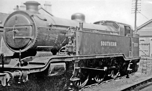
English: LB&&SCR Marsh class J1 4-6-2T at Tunbridge Wells West, 1946 Seen in Tunbridge Wells West Shed Yard is the first of a pair of ex-LB&SCR 4-6-2Ts, No. 325, built 12/1910 named 'Abergavenny' until 1924 when the SR renumbered it 2325 and dropped the name; it was withdrawn 6/51 and scrapped. (The other and similar 4-6-2T, J2 No 326 'Bessborough', was built in 3/1912 and suffered the same fate at the same date). |
| Date | |
| Source | From geograph.org.uk |
| Author | Ben Brooksbank |
| Permission (Reusing this file) |
Creative Commons Attribution Share-alike license 2.0 |
| Attribution (required by the license) | Ben Brooksbank / LB&&SCR Marsh class J1 4-6-2T at Tunbridge Wells West, 1946 / |
| Camera location | | View this and other nearby images on: OpenStreetMap |
|---|
.jpg¶ms=051.123794_N_0000.252949_E_globe:Earth_type:camera_heading:22.00_source:geograph&language=en)
| Object location | | View this and other nearby images on: OpenStreetMap |
|---|
.jpg¶ms=051.123750_N_0000.253000_E_globe:Earth_class:object_type:object_source:geograph-osgb36(TQ57763846)_region:GB-GBN_heading:22.00&language=en)
Licensing
[edit].jpg&action=edit§ion=2)

|
This image was taken from the Geograph project collection. See this photograph's page on the Geograph website for the photographer's contact details. The copyright on this image is owned by Ben Brooksbank and is licensed for reuse under the Creative Commons Attribution-ShareAlike 2.0 license.
|
This file is licensed under the Creative Commons Attribution-Share Alike 2.0 Generic license.
Attribution: Ben Brooksbank
- You are free:
- to share – to copy, distribute and transmit the work
- to remix – to adapt the work
- Under the following conditions:
- attribution – You must give appropriate credit, provide a link to the license, and indicate if changes were made. You may do so in any reasonable manner, but not in any way that suggests the licensor endorses you or your use.
- share alike – If you remix, transform, or build upon the material, you must distribute your contributions under the same or compatible license as the original.
File history
Click on a date/time to view the file as it appeared at that time.
| Date/Time | Thumbnail | Dimensions | User | Comment | |
|---|---|---|---|---|---|
| current | 11:47, 29 July 2017 | | 2,430 × 1,465 (1.64 MB) | Das48 (talk | contribs) | Transferred from geograph.co.uk using [https://tools.wmflabs.org/geograph2commons/ geograph2commons] |
You cannot overwrite this file.
File usage on Commons
There are no pages that use this file.
File usage on other wikis
The following other wikis use this file:
- Usage on de.wikipedia.org
- Usage on en.wikipedia.org
.jpg&oldid=943533635)