File:Lünersee vom Saulakopf 1.JPG
Jump to navigation
Jump to search
Size of this preview: 800 × 533 pixels. Other resolutions: 320 × 213 pixels | 640 × 427 pixels | 1,024 × 683 pixels | 1,280 × 853 pixels | 2,560 × 1,707 pixels | 4,125 × 2,750 pixels.
Original file (4,125 × 2,750 pixels, file size: 6.34 MB, MIME type: image/jpeg)
Captions
Captions
Add a one-line explanation of what this file represents
| Description |
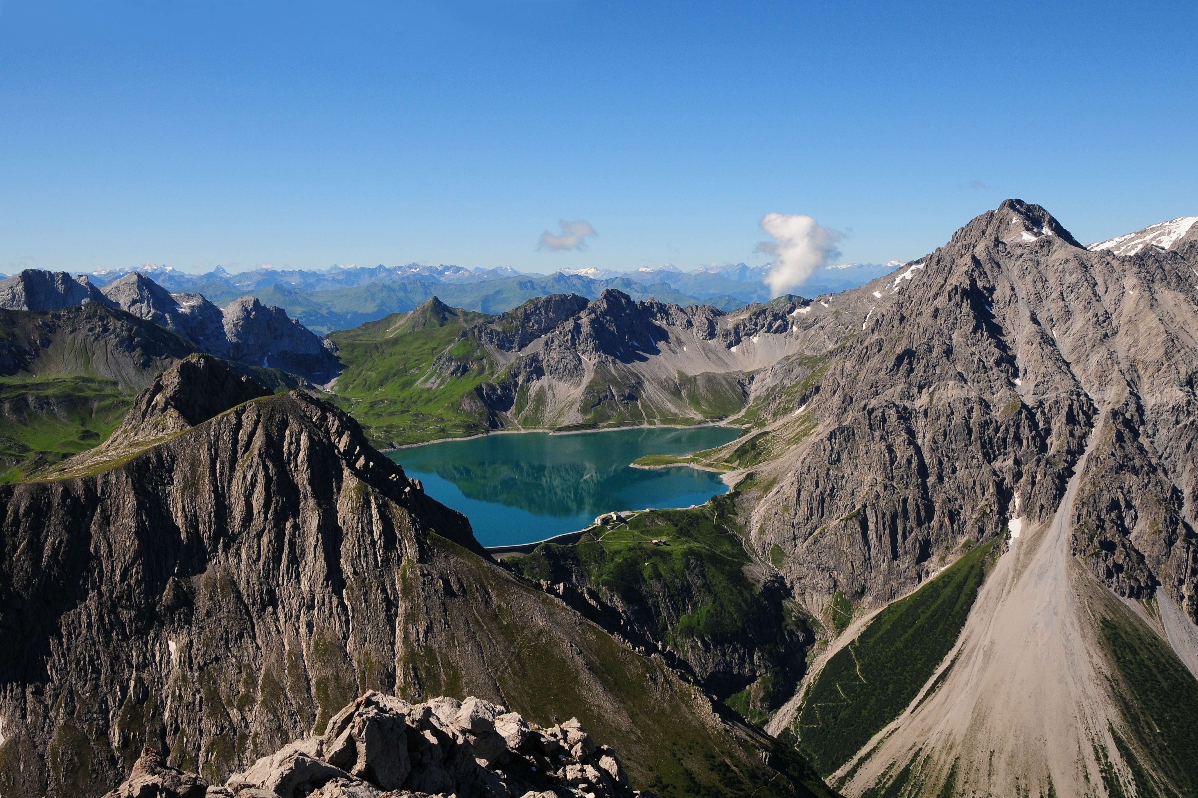
Deutsch: Der Lünersee, gesehen vom Saulakopf 2.517 m. Links der Schafgafall 2.414 m und rechts der Seekopf 2.698 m mit dem Schuttkegel, der bis zur Talstation der Lünerseebahn reicht. Hinter dem See die Kanzelköpfe 2.437 m und auf Schweizer Gebiet (der spitze Berg) die Girenspitze mit 2.394 m.
English: The Lüner Lake, seen from Mt. Saulakopf (2,517 m) in Austria. Left is Mt. Schafgafall (2,414 m) and right Mt. Seekopf (2.698 m). Behind the lake are Mt. Kanzelköpfe (2,437 m) and Mt. Girenspitze (2,394 m) in Switzerland.
Français : Le lac de Lüner (Lünersee) en Autriche, vu du Saulakopf (Tête de cochon).
Sunda: Talaga Lüner ditempo ti Gn. Saulakopf (2.517 m) di Austria. Di beulah kénca Gn. Schafgafall (2.414 m), beulah katuhu Gn. Seekopf (2.698 m). Anu di tukangeun talaga, Gn. Kanzelköpfe (2.437 m) jeung Gn. Girenspitze (2.394 m) mah kaasup wilayah Suis. |
| Date | |
| Source | Own work |
| Author | böhringer friedrich |
| Permission (Reusing this file) |
I, the copyright holder of this work, hereby publish it under the following license: This file is licensed under the Creative Commons Attribution-Share Alike 2.5 Generic license.
|
|

This Photo was taken by Böhringer Friedrich.
|
Feel free to use my photos, but please mention me as the author and if you want send me a message. or (rufre@lenz-nenning.at) |
| Camera location | | View this and other nearby images on: OpenStreetMap |
|---|
This image has been assessed using the Quality image guidelines and is considered a Quality image.
|
File history
Click on a date/time to view the file as it appeared at that time.
| Date/Time | Thumbnail | Dimensions | User | Comment | |
|---|---|---|---|---|---|
| current | 21:32, 6 August 2010 | | 4,125 × 2,750 (6.34 MB) | Böhringer (talk | contribs) | Excellent picture (but please remove the white dot in the middle of the upper edge) erledigt |
| 22:06, 2 August 2010 |  | 4,125 × 2,750 (6.33 MB) | Böhringer (talk | contribs) | {{Information |Description= {{de| Der Lünersee, gesehen vom Saulakopf 2.517m. Links der Schafgafall 2.414m und rechts der Seekopf 2.698m mit dem Schuttkegel, der bis zur Talstation der Lünerseebahn reicht. Hinter dem | |
| 21:36, 1 August 2010 |  | 4,288 × 2,848 (7.74 MB) | Böhringer (talk | contribs) | {{Information |Description= {{de| Der Lünersee, gesehen vom Saulakopf 2.517m. Links der Schafgafall 2.414m und rechts der Seekopf 2.698m mit dem Schuttkegel, der bis zur Talstation der Lünerseebahn reicht. Hinter dem |
You cannot overwrite this file.
File usage on Commons
The following 24 pages use this file:
- Exzellente Bilder aus Vorarlberg
- Vorarlberg
- User:Böhringer
- User:Böhringer/Archive 3
- User:Ö/Best/2010
- Commons:Featured picture candidates/File:Lünersee vom Saulakopf 1.JPG
- Commons:Featured picture candidates/Log/August 2010
- Commons:Featured pictures/Places/Natural/Austria
- Commons:Featured pictures/chronological/2010-B
- Commons:Picture of the Year/2010/Galleries/Index/9
- Commons:Picture of the Year/2010/Galleries/Index/Nature views
- Commons:Picture of the Year/2010/Galleries/Nature views
- Commons:Picture of the Year/2010/Galleries/Nature views/Large
- Commons:Picture of the Year/2010/Galleries/Nature views/Small
- Commons:Picture of the Year/2010/Galleries/Table
- Commons:Picture of the Year/2010/Galleries/Table/08
- Commons:Picture of the Year/2010/R1/File:Lünersee vom Saulakopf 1.JPG
- Commons:Picture of the Year/2010/Results/R1/ALL/Table
- Commons:Picture of the Year/2010/Results/R1/Nature views
- Commons:Picture of the Year/2010/Results/R1/Nature views/Table
- Commons:Quality images/Subject/Places/Natural structures/archive 2008 to 2012
- Commons:Quality images candidates/Archives August 2010
- Commons talk:Picture of the Year/2010/Galleries/Table
- Commons talk:Picture of the Year/2010/Results/R1/ALL/Table
File usage on other wikis
The following other wikis use this file:
- Usage on ar.wikipedia.org
- Usage on de.wikipedia.org
- Usage on en.wikipedia.org
- Usage on es.wikipedia.org
- Usage on fa.wikipedia.org
- Usage on fr.wikipedia.org
- Usage on nl.wikipedia.org
- Usage on pl.wikipedia.org
- Usage on pnb.wikipedia.org
- Usage on simple.wikipedia.org
- Usage on sq.wikipedia.org
- Usage on su.wikipedia.org
- Usage on sv.wikipedia.org
- Usage on uk.wikipedia.org
- Usage on vi.wikipedia.org