File:Lôn Dywod Pwllheli - geograph.org.uk - 919079.jpg
Jump to navigation
Jump to search
No higher resolution available.
Lôn_Dywod_Pwllheli_-_geograph.org.uk_-_919079.jpg (640 × 428 pixels, file size: 88 KB, MIME type: image/jpeg)
Captions
Captions
Add a one-line explanation of what this file represents
Summary
[edit]
| Description |
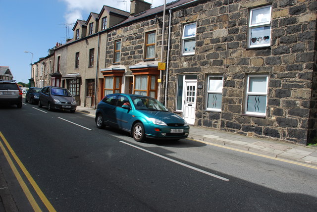
English: Lôn Dywod Pwllheli Lôn Dywod leads from Stryd Fawr to the railway station. Its name (Sand Street) is a reminder of how much closer the sea was to the town in past centuries.
This busy road is the main way out of town to the roads to Caernarfon and Porthmadog, and so carries constant heavy traffic. The house at the right of the picture is called Sŵn y Lôn (road noise) - a light-hearted play on more common house names such as Sŵn y Môr (sound of the sea) or Sŵn y Don (sound of the wave). |
| Date | |
| Source | From geograph.org.uk |
| Author | Alan Fryer |
| Attribution (required by the license) | Alan Fryer / Lôn Dywod Pwllheli / |
| Camera location | | View this and other nearby images on: OpenStreetMap |
|---|
_heading:225.00&language=en)
| Object location | | View this and other nearby images on: OpenStreetMap |
|---|
_heading:225.00&language=en)
Licensing
[edit]

|
This image was taken from the Geograph project collection. See this photograph's page on the Geograph website for the photographer's contact details. The copyright on this image is owned by Alan Fryer and is licensed for reuse under the Creative Commons Attribution-ShareAlike 2.0 license.
|
This file is licensed under the Creative Commons Attribution-Share Alike 2.0 Generic license.
Attribution: Alan Fryer
- You are free:
- to share – to copy, distribute and transmit the work
- to remix – to adapt the work
- Under the following conditions:
- attribution – You must give appropriate credit, provide a link to the license, and indicate if changes were made. You may do so in any reasonable manner, but not in any way that suggests the licensor endorses you or your use.
- share alike – If you remix, transform, or build upon the material, you must distribute your contributions under the same or compatible license as the original.
File history
Click on a date/time to view the file as it appeared at that time.
| Date/Time | Thumbnail | Dimensions | User | Comment | |
|---|---|---|---|---|---|
| current | 23:23, 21 February 2011 | | 640 × 428 (88 KB) | GeographBot (talk | contribs) | == {{int:filedesc}} == {{Information |description={{en|1=Lôn Dywod Pwllheli Lôn Dywod leads from Stryd Fawr to the railway station. Its name (Sand Street) is a reminder of how much closer the sea was to the town in past centuries. This busy road is the |
You cannot overwrite this file.
File usage on Commons
There are no pages that use this file.