File:Kurfürstenturm Braunschweig Lüneburg Kupferstich.jpg
Jump to navigation
Jump to search

Size of this preview: 800 × 484 pixels. Other resolutions: 320 × 194 pixels | 640 × 387 pixels | 1,024 × 620 pixels | 1,280 × 775 pixels | 2,560 × 1,550 pixels | 4,110 × 2,488 pixels.
Original file (4,110 × 2,488 pixels, file size: 10.11 MB, MIME type: image/jpeg)
Captions
Captions
Add a one-line explanation of what this file represents
Summary
[edit]| Artist |
|
|||||||||||||||||||||||
| Description |
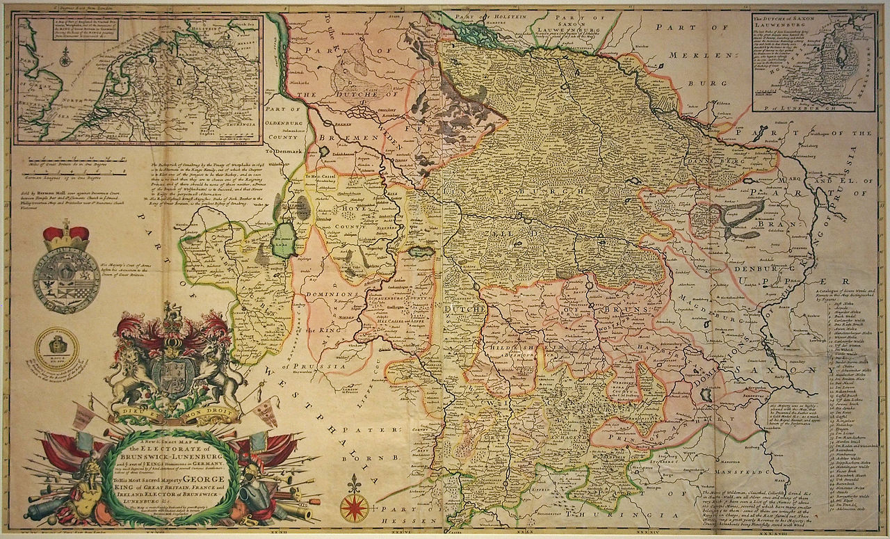
English: A new exact map of the Elcctoratc of Brunswick-Lüneburg. The map was designed to present the German State of their king, George I, to the British population. The king's route on visits to Germany is shown at the top. In 1722 the Electorate of Brunswick-Lüneburg con-sisted of the principalities of Calenberg, Göttingen, Grubenhagen and Lüneburg, the counties of Diepholz and Hoya and the duchies of Lauenburg, Bremen and Verden.
Deutsch: Kolorierter Kupferstich vom Kurfürstentum Braunschweig-Lüneburg. Die Karte diente dazu, der Bevölkerung Großbritanniens den deutschen Staat ihres Königs Georg I. vorzustellen. Oben ist die Reiseroute des Königs bei Besuchen in Hannover dargestellt. Das Kurfürstentum setzte sich 1722 aus den Fürstentümern Calenberg, Göttingen, Grubenhagen und Lüneburg, den Grafschaften Diepholz und Hoya sowie den Herzogtümern Lauenburg, Bremen und Verden zusammen. |
|||||||||||||||||||||||
| Date | 1722 | |||||||||||||||||||||||
| Medium | copper engraving print | |||||||||||||||||||||||
| Source/Photographer | Museum Herrenhausen Palace, uploader was Hajotthu at de.wikipedia | |||||||||||||||||||||||

Licensing
[edit]
|
This is a faithful photographic reproduction of a two-dimensional, public domain work of art. The work of art itself is in the public domain for the following reason:
The official position taken by the Wikimedia Foundation is that "faithful reproductions of two-dimensional public domain works of art are public domain".
This photographic reproduction is therefore also considered to be in the public domain in the United States. In other jurisdictions, re-use of this content may be restricted; see Reuse of PD-Art photographs for details. | ||||
File history
Click on a date/time to view the file as it appeared at that time.
| Date/Time | Thumbnail | Dimensions | User | Comment | |
|---|---|---|---|---|---|
| current | 17:08, 10 September 2013 | | 4,110 × 2,488 (10.11 MB) | Hajotthu (talk | contribs) | == {{int:filedesc}} == {{Artwork |Description ={{en|1=A new exact map of the Elcctoratc of Brunswick-Lüneburg. The map was designed to present the German State of their king, George I, to the British population. The king's route on visits to German... |
You cannot overwrite this file.
File usage on Commons
The following page uses this file:
File usage on other wikis
The following other wikis use this file:
- Usage on de.wikipedia.org