File:Killer Winter Storm Rolls Across North America (MODIS).jpg

Original file (6,303 × 4,757 pixels, file size: 4.45 MB, MIME type: image/jpeg)
Captions
Captions
Summary
[edit].jpg&action=edit§ion=1)
| Description |
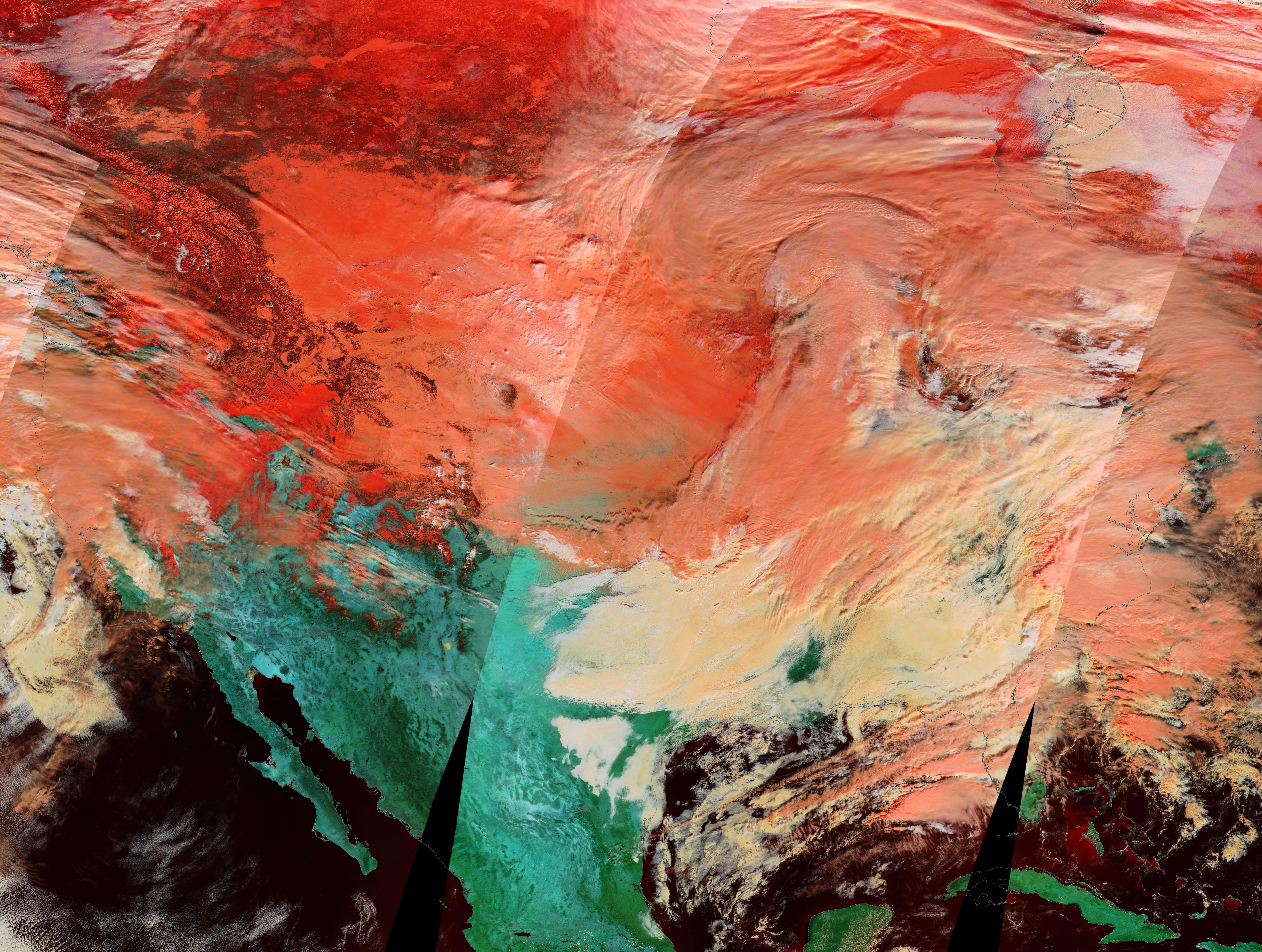
English: On December 22, 2022, the Moderate Resolution Imaging Spectroradiometer (MODIS) acquired a false-color image of a vicious and frigid winter storm as it rolled across the United States. On that date, a newscaster reported that the storm stretched “from coast to coast and border to border”, and this image proves that description to be true. However, it was an understatement. Not only did the storm lay a tremendous wallop on the Lower 48 U.S. states, but it also stretched northward to pummel Canada.
In this type of false-color image, blue and shortwave infrared light (MODIS bands 3,6,7) are used to highlight the different reflectivity of snow, ice, clouds, and vegetation. The bold green marks areas of vegetation, while bright red marks highly reflective and cold snow or ice. Clouds appear white or, if they contain ice crystals, may look light peach. The deep peach is most likely extremely cold cloud and snow. In the United States, the cross-country storm first wound up in the Pacific Northwest on December 20, dropping up to two feet of snow in the Cascade Mountains. By the next day, it was dropping both snow and temperatures over the Rockies and the Great Plains. According to The Weather Channel, temperatures in Denver, Colorado dropped 37 degrees in only one hour, then dropped even more to settle about -24˚F (-31˚C) early on December 22. After shutting down traffic across the Great Plains, the storm intensified so rapidly that it met the criteria for a "bomb cyclone”, which is a drop of at least 24 millibars (a measure of atmospheric pressure) over 24 hours. A rapid drop in atmospheric pressure creates an “explosive” storm that can carry super-strong, damaging winds. The winds became very strong, indeed. A gust was measured at 79 mph (127 km/h) at Buffalo-Niagara International Airport on December 23. The cold even reached the southern state of Florida, where lows of 14˚F (-10˚C) are expected by the early morning hours of December 25. And on December 24, Bloomberg reported that the U.S. Energy Department declared a power emergency in Texas, as some power plants began to fail. Meanwhile, north of the border, every province and territory in Canada had issued an emergency weather warning on December 24—a total of 425 in all—as wind chills hit -50˚C (-58˚F) in some locations. Across both countries, many thousands of airline flights were cancelled, many traffic pile-ups were reported, schools were cancelled, and people struggled to cope with the cold, wind, snow, and even serious coastal storm surges. As of December 24, the storm has taken 20 lives in the United States. |
||
| Date | Taken on 22 December 2022 | ||
| Source |
Killer Winter Storm Rolls Across North America (direct link)
|
||
| Author | MODIS Land Rapid Response Team, NASA GSFC |
| This media is a product of the Terra mission Credit and attribution belongs to the mission team, if not already specified in the "author" row |
Licensing
[edit].jpg&action=edit§ion=2)
| This file is in the public domain in the United States because it was solely created by NASA. NASA copyright policy states that "NASA material is not protected by copyright unless noted". (See Template:PD-USGov, NASA copyright policy page or JPL Image Use Policy.) | ||
 |
Warnings:
|
File history
Click on a date/time to view the file as it appeared at that time.
| Date/Time | Thumbnail | Dimensions | User | Comment | |
|---|---|---|---|---|---|
| current | 12:59, 8 August 2023 | | 6,303 × 4,757 (4.45 MB) | OptimusPrimeBot (talk | contribs) | #Spacemedia - Upload of http://modis.gsfc.nasa.gov/gallery/images/image12252022_1km.jpg via Commons:Spacemedia |
You cannot overwrite this file.
File usage on Commons
There are no pages that use this file.
.jpg&oldid=909384613)