File:Karte passau in deutschland.png
Jump to navigation
Jump to search
No higher resolution available.
Karte_passau_in_deutschland.png (188 × 235 pixels, file size: 5 KB, MIME type: image/png)
Captions
Captions
Add a one-line explanation of what this file represents
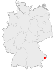
Position of Passau in Germany
This image was generated with OpenGeoDB. The information there is placed in the public domain, images generated from OpenGeoDB are derivative works without passing the threshold of creativity, they are therefore also public domain.
| This work is ineligible for copyright and therefore in the public domain because it consists entirely of information that is common property and contains no original authorship. |
File history
Click on a date/time to view the file as it appeared at that time.
| Date/Time | Thumbnail | Dimensions | User | Comment | |
|---|---|---|---|---|---|
| current | 20:06, 16 December 2005 | | 188 × 235 (5 KB) | Markussep (talk | contribs) | Position of Passau in Germany {{GFDL-OpenGeoDB}} source:http://www.opengeodb.de/index.php |
You cannot overwrite this file.
File usage on Commons
The following page uses this file:
File usage on other wikis
The following other wikis use this file:
- Usage on azb.wikipedia.org
- Usage on eo.wikipedia.org
- Usage on la.wikipedia.org
- Usage on pl.wikivoyage.org
- Usage on sk.wikipedia.org