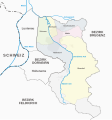
File:Karte Stadtbezirke Dornbirn.svg

From Wikimedia Commons, the free media repository
Jump to navigation Jump to search

Original file (SVG file, nominally 960 × 1,025 pixels, file size: 447 KB)

Captions

Captions

Districts of the city of Dornbirn

Summary

[edit]
Description
Deutsch: Stadtbezirke von Dornbirn
Date
Source Own work, Grenzen: Stadt Dornbirn. Seite 64., Siedlungsgebiet: Openstreetmap, Flüsse: Dornbirner_Ache.png, Farbgebung in Anlehnung an Tschubbys Karten
Author Bratwurst mit Sauerkraut
Permission
(Reusing this file)
I, the copyright holder of this work, hereby publish it under the following licenses:
GNU head Permission is granted to copy, distribute and/or modify this document under the terms of the GNU Free Documentation License, Version 1.2 or any later version published by the Free Software Foundation; with no Invariant Sections, no Front-Cover Texts, and no Back-Cover Texts. A copy of the license is included in the section entitled GNU Free Documentation License.
w:en:Creative Commons
attribution share alike
This file is licensed under the Creative Commons Attribution-Share Alike 3.0 Unported license.
You are free:
  • to share – to copy, distribute and transmit the work
  • to remix – to adapt the work
Under the following conditions:
  • attribution – You must give appropriate credit, provide a link to the license, and indicate if changes were made. You may do so in any reasonable manner, but not in any way that suggests the licensor endorses you or your use.
  • share alike – If you remix, transform, or build upon the material, you must distribute your contributions under the same or compatible license as the original.
This licensing tag was added to this file as part of the GFDL licensing update.
w:en:Creative Commons
attribution share alike
This file is licensed under the Creative Commons Attribution-Share Alike 2.5 Generic, 2.0 Generic and 1.0 Generic license.
You are free:
  • to share – to copy, distribute and transmit the work
  • to remix – to adapt the work
Under the following conditions:
  • attribution – You must give appropriate credit, provide a link to the license, and indicate if changes were made. You may do so in any reasonable manner, but not in any way that suggests the licensor endorses you or your use.
  • share alike – If you remix, transform, or build upon the material, you must distribute your contributions under the same or compatible license as the original.
You may select the license of your choice.

Daten für eine Imagemap mit dieser Karte

[edit]

Nota bene: Die Links in der Liste funktionieren so nur in der Wikipedia.

  • poly 336 142 309 357 364 385 429 378 454 372 456 350 420 291 416 236 433 208 419 199 406 208 392 140 377 138 353 150 Schoren
  • poly 561 416 458 351 443 323 495 295 482 243 551 274 668 219 705 265 704 334 660 310 645 327 604 306 541 308 513 330 507 363 574 396 572 404 Markt
  • poly 464 166 484 240 552 269 669 215 710 262 728 257 722 236 736 217 743 178 705 156 659 180 619 167 577 185 559 210 510 196 508 181 Haselstauden
  • poly 397 140 432 144 459 162 490 294 442 319 425 292 420 232 439 206 419 193 408 203 Rohrbach
  • poly 310 364 313 407 328 435 387 475 456 500 495 495 561 539 548 571 560 592 576 573 572 617 594 611 593 582 626 463 565 422 460 357 458 378 365 389 Hatlerdorf
  • poly 704 340 719 364 737 374 744 430 762 450 785 463 797 495 816 505 824 510 831 513 837 536 811 564 858 611 782 640 770 653 746 664 731 687 782 749 759 757 764 793 789 804 756 839 723 834 662 852 637 893 542 849 542 832 570 824 517 792 521 724 555 654 599 625 597 609 597 577 631 461 570 416 582 393 512 363 515 331 544 313 599 311 645 333 661 316 Oberdorf
  • poly 754 841 750 867 775 881 794 903 857 912 864 966 800 1008 764 977 698 969 674 970 647 935 645 905 592 882 561 894 542 885 511 874 492 840 478 824 478 803 445 777 441 743 416 731 432 697 418 689 435 634 494 620 505 625 561 597 572 584 569 621 592 614 593 625 551 650 515 725 515 794 563 823 538 831 538 851 639 898 662 855 724 837 Ebnit
  • poly 799 1012 777 1023 960 1024 957 1 0 0 0 65 14 19 32 31 69 94 144 99 200 127 269 71 278 92 334 137 351 141 380 132 432 138 464 159 514 180 514 191 556 205 576 178 620 163 657 176 708 152 748 177 738 224 726 233 735 259 707 268 707 337 720 357 742 371 749 428 788 461 800 493 832 509 841 536 816 564 863 612 784 643 774 656 750 665 738 685 789 752 762 760 766 788 794 803 756 843 754 865 777 877 795 899 860 910 868 968 Bezirk Bregenz
  • poly 772 1024 795 1007 761 979 675 975 641 940 638 907 590 886 552 901 506 875 472 826 470 805 441 783 434 748 410 734 425 700 415 698 387 730 334 679 320 691 297 676 234 689 209 629 211 605 154 567 75 570 0 647 1 1022 Bezirk Feldkirch
  • poly 245 444 247 470 238 512 203 549 162 568 213 603 213 627 237 683 298 672 319 683 333 673 390 721 412 690 432 630 494 616 507 621 558 594 543 573 555 538 493 500 452 507 383 480 317 435 Hohenems
  • poly 245 440 221 419 195 408 169 353 162 278 138 206 200 133 266 85 329 144 306 368 309 413 321 431 Lustenau
  • poly 3 640 70 568 161 560 216 529 238 488 241 446 211 423 182 401 165 350 155 277 135 202 192 130 140 104 67 100 27 34 14 30 0 72 1 643 Schweiz

File history

Click on a date/time to view the file as it appeared at that time.

Date/TimeThumbnailDimensionsUserComment
current13:01, 28 November 2021Thumbnail for version as of 13:01, 28 November 2021960 × 1,025 (447 KB)Bratwurst mit Sauerkraut (talk | contribs)Fixed font issues
11:54, 28 November 2021Thumbnail for version as of 11:54, 28 November 2021960 × 1,025 (338 KB)Bratwurst mit Sauerkraut (talk | contribs)Uploaded own work with UploadWizard

The following page uses this file:

File usage on other wikis

The following other wikis use this file:

Metadata