File:Karabakh war 2020 I.svg

Original file (SVG file, nominally 1,377 × 1,186 pixels, file size: 829 KB)
Captions
Captions
Summary
[edit]| DescriptionKarabakh war 2020 I.svg |
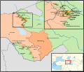
English: Armenian–Azerbaijani clashes July to September 2020, before the war in 2020. Reported events are often contested by the other party.
Deutsch: Zusammenstöße zwischen armenischen und aserbaidschanischen Streitkräften von Juli bis September 2020, vor dem Krieg ab 27. September 2020. Die gemeldeten Ereignisse sind meist von der Gegenseite bestritten worden.
|
| Date | |
| Source |
Own work; official borders: Armenia adm location map.svg, Azerbaijan adm location map.svg; water bodies: OpenStreetMap |
| Author | Don-kun, sources: NordNordWest |
Licensing
[edit]- You are free:
- to share – to copy, distribute and transmit the work
- to remix – to adapt the work
- Under the following conditions:
- attribution – You must give appropriate credit, provide a link to the license, and indicate if changes were made. You may do so in any reasonable manner, but not in any way that suggests the licensor endorses you or your use.
File history
Click on a date/time to view the file as it appeared at that time.
| Date/Time | Thumbnail | Dimensions | User | Comment | |
|---|---|---|---|---|---|
| current | 18:41, 30 December 2020 |  | 1,377 × 1,186 (829 KB) | Don-kun (talk | contribs) | fix frame |
| 18:39, 30 December 2020 |  | 1,384 × 1,193 (829 KB) | Don-kun (talk | contribs) | other font | |
| 14:08, 22 December 2020 |  | 1,384 × 1,193 (1.12 MB) | Don-kun (talk | contribs) | {{Information |Description=Armenian–Azerbaijani clashes before the war in 2020 |Source={{own}};<br /> official borders: Armenia adm location map.svg, Azerbaijan adm location map.svg;<br /> water bodies: OpenStreetMap |Date=2020-12-22 |Author=Don-kun, sources: NordNordWest |Permission= |other_versions= }} Category:Maps of the 2020 Nagorno-Karabakh conflict [[Category:Maps... |
You cannot overwrite this file.
File usage on Commons
The following page uses this file:
File usage on other wikis
The following other wikis use this file:
- Usage on de.wikipedia.org
- Usage on eu.wikipedia.org
Metadata
This file contains additional information such as Exif metadata which may have been added by the digital camera, scanner, or software program used to create or digitize it. If the file has been modified from its original state, some details such as the timestamp may not fully reflect those of the original file. The timestamp is only as accurate as the clock in the camera, and it may be completely wrong.
| Width | 388.69861mm |
|---|---|
| Height | 334.76248mm |