File:Kamchatka amo 2013143 lrg.jpg

Original file (5,000 × 3,000 pixels, file size: 3.64 MB, MIME type: image/jpeg)
Captions
Captions
Summary
[edit]| DescriptionKamchatka amo 2013143 lrg.jpg |
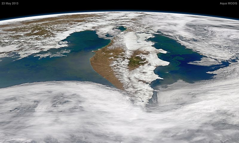
English: The Kamchatka Peninsula of far eastern Russian was surrounded by life in late May 2013—at least the oceanic sort. Massive blooms of microscopic, plant-like organisms called phytoplankton spread green over the nearby waters. Phytoplankton typically support an abundance of other fish and marine life.
The Moderate Resolution Imaging Spectroradiometer (MODIS) on NASA's Aqua satellite captured the natural-color imagery to make this composite view on May 23, 2013. Looking toward the North Pole from the southern end of the peninsula, blooms of chlorophyll-rich cells appear off both the west coast—in the Sea of Okhotsk—and to the east in the North Pacific Ocean. Stretching nearly 1,250-kilometers (780 mile) from north to south, the peninsula is dotted with volcanoes, some of which are faintly visible in the image above. (Click on the large version for a better view.) Kamchatka lies along the Pacific “Ring of Fire,” an area of extremely active volcanism and plate tectonic earthquakes. That volcanism probably played some part in these blooms. Several volcanoes—including Kizimen, Shiveluch, and Bezymianny—have been spewing iron-rich ash and lava, both of which fall in the ocean. Iron also runs off the land in rivers and gets churned up from the ocean floor by currents and storms. Iron is a key nutrient for phytoplankton growth, as it helps them process nitrate. The east side of the Peninsula is also bathed in the cool, nutrient-rich Oyashio Current, which originates in Arctic waters and flows south along the coast of Siberia and Kamchatka toward Japan. Caption by Mike Carlowicz. |
| Date | |
| Source | http://earthobservatory.nasa.gov/IOTD/view.php?id=81258 |
| Author | Image by Norman Kuring, NASA Ocean Color Group. Photo taken by the Moderate Resolution Imaging Spectroradiometer (MODIS) on NASA's Aqua satellite. |
Licensing
[edit]| Public domainPublic domainfalsefalse |
| This file is in the public domain in the United States because it was solely created by NASA. NASA copyright policy states that "NASA material is not protected by copyright unless noted". (See Template:PD-USGov, NASA copyright policy page or JPL Image Use Policy.) |  | |
 |
Warnings:
|
File history
Click on a date/time to view the file as it appeared at that time.
| Date/Time | Thumbnail | Dimensions | User | Comment | |
|---|---|---|---|---|---|
| current | 02:19, 12 June 2013 |  | 5,000 × 3,000 (3.64 MB) | Melikamp (talk | contribs) | User created page with UploadWizard |
You cannot overwrite this file.
File usage on Commons
The following 10 pages use this file:
- Commons:WikiProject Aviation/recent uploads/2013 June 12/part 1
- Category:Education in Kamchatka Krai
- Category:Kamchatka Krai
- Category:Maps of Kamchatka Krai
- Category:Natural monuments in Kamchatka Krai
- Category:People of Kamchatka Krai
- Category:Protected areas of Kamchatka Krai
- Category:Rivers of Kamchatka Krai
- Category:Transport in Kamchatka Krai
- Category:Visitor attractions in Kamchatka Krai
File usage on other wikis
The following other wikis use this file:
- Usage on ar.wikipedia.org
- Usage on arz.wikipedia.org
- Usage on ast.wikipedia.org
- Usage on az.wikipedia.org
- Usage on be.wikipedia.org
- Usage on ca.wikipedia.org
- Usage on ceb.wikipedia.org
- Usage on ce.wikipedia.org
- Usage on cs.wikipedia.org
- Usage on cy.wikipedia.org
- Usage on de.wikivoyage.org
- Usage on el.wikipedia.org
- Usage on en.wikipedia.org
- Usage on en.wikivoyage.org
- Usage on eo.wikipedia.org
- Usage on eu.wikipedia.org
- Usage on fr.wikipedia.org
- Usage on fr.wikivoyage.org
- Usage on ga.wikipedia.org
- Usage on gl.wikipedia.org
- Usage on he.wikipedia.org
- Usage on it.wikipedia.org
- Usage on ja.wikipedia.org
- Usage on lmo.wikipedia.org
- Usage on mdf.wikipedia.org
- Usage on mhr.wikipedia.org
- Usage on myv.wikipedia.org
- Usage on mzn.wikipedia.org
- Usage on nn.wikipedia.org
- Usage on no.wikipedia.org
- Usage on pl.wikipedia.org
- Usage on ro.wikipedia.org
- Usage on ru.wikipedia.org
- Usage on ru.wikinews.org
- Usage on sl.wikipedia.org
- Usage on sr.wikipedia.org
- Usage on tt.wikipedia.org
- Usage on uk.wikipedia.org
- Usage on vec.wikipedia.org
- Usage on www.wikidata.org
Metadata
This file contains additional information such as Exif metadata which may have been added by the digital camera, scanner, or software program used to create or digitize it. If the file has been modified from its original state, some details such as the timestamp may not fully reflect those of the original file. The timestamp is only as accurate as the clock in the camera, and it may be completely wrong.
| JPEG file comment | Satellite: Aqua
Sensor: MODIS Date: 23 May 2013 Description: Oblique view northward along the Kamchatka Peninsula Red channel: Band 1 (620-670 nm) Green channel: Band 4 (545-565 nm) Blue channel: Band 3 (459-479 nm) Projection: tilted near-sided perspective Projection details: mapproject -Rd -Jg148/34/1.3/15/45/0/30/30/1:400000 | nearneighbor -R60/110/70/100 -I0.01Image created by: Norman Kuring |
|---|