File:Kadasterkaart Maastricht 1823-1830, sectie B, blad 09, Binnenstad (Vleeshuis).jpg
Jump to navigation
Jump to search

Size of this preview: 800 × 473 pixels. Other resolutions: 320 × 189 pixels | 640 × 378 pixels | 1,024 × 606 pixels | 1,373 × 812 pixels.
Original file (1,373 × 812 pixels, file size: 344 KB, MIME type: image/jpeg)
Captions
Captions
Add a one-line explanation of what this file represents
Summary
[edit]| Description |
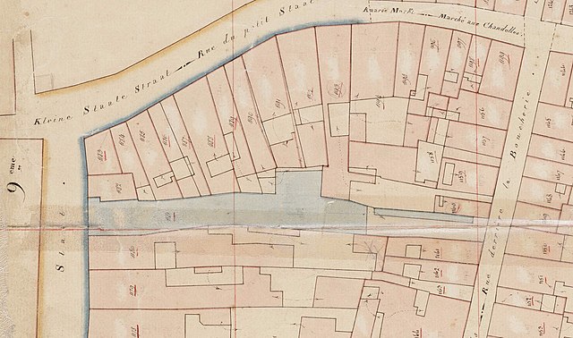
Nederlands: Detail van de kadastrale minuutkaart van Maastricht, sectie B, blad 09, perceelnummers 978-1384. Op dit fragment is een deel van de Binnenstad weergegeven. In blauw: overheids- en kerkelijke gebouwen, waaronder de Vleeshal. Verder o.a. Grote Staat, Kleine Staat, Kersenmarkt en Achter het Vleeshuis. Collectie HCL Maastricht, Kadaster Limburg, MIN11058B09. |
| Date | between 1823 and 1830 |
| Source | https://beeldbank.rhcl.nl/detail.php?nav_id=0-1&id=5052780&index=21 |
| Author | P.J. Sotiau (Kadaster Limburg) |
| Other versions |
_(cropped).jpg)

.jpg&action=edit§ion=1)
Licensing
[edit].jpg&action=edit§ion=2)
|
This work is in the public domain in its country of origin and other countries and areas where the copyright term is the author's life plus 70 years or fewer. This work is in the public domain in the United States because it was published (or registered with the U.S. Copyright Office) before January 1, 1929. | |
| This file has been identified as being free of known restrictions under copyright law, including all related and neighboring rights. | |
File history
Click on a date/time to view the file as it appeared at that time.
| Date/Time | Thumbnail | Dimensions | User | Comment | |
|---|---|---|---|---|---|
| current | 16:29, 10 August 2022 | | 1,373 × 812 (344 KB) | Kleon3 (talk | contribs) | File:Kadasterkaart Maastricht 1823-1830, sectie B, blad 09, Binnenstad.jpg cropped 77 % horizontally, 79 % vertically, rotated 270° using CropTool with precise mode. |
You cannot overwrite this file.
File usage on Commons
The following 2 pages use this file:
File usage on other wikis
The following other wikis use this file:
- Usage on nl.wikipedia.org
.jpg&oldid=728719978)