File:KY 2541 Bridge.jpg
Jump to navigation
Jump to search

Size of this preview: 751 × 599 pixels. Other resolutions: 301 × 240 pixels | 602 × 480 pixels | 1,010 × 806 pixels.
Original file (1,010 × 806 pixels, file size: 466 KB, MIME type: image/jpeg)
Captions
Captions
Add a one-line explanation of what this file represents
|
This is an image of a place or building that is listed on the National Register of Historic Places in the United States of America. Its reference number is 87002446. |
| Camera location | | View this and other nearby images on: OpenStreetMap |
|---|
| Description |
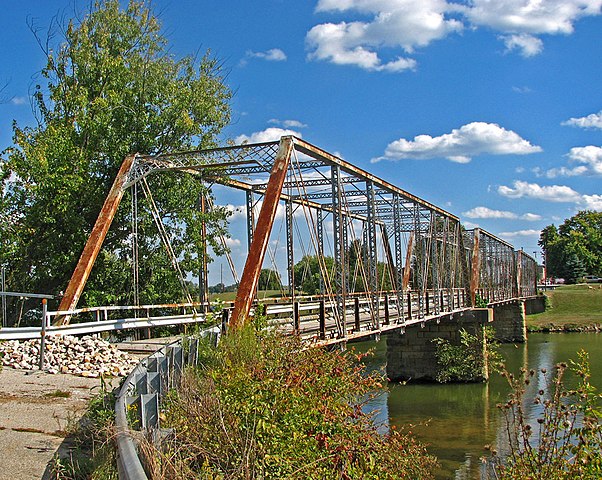
English: One end of the KY 2541 Bridge, which carried Main Street (Kentucky Route 2541, formerly U.S. Route 23) over the Little Sandy River in Greenup, Kentucky, United States. Built in 1884, it is listed on the National Register of Historic Places. |
| Date | |
| Source | Flickr |
| Author | dok1 |
| Permission (Reusing this file) |
This file is licensed under the Creative Commons Attribution 2.0 Generic license.
|
| This image was originally posted to Flickr by dok1 at https://www.flickr.com/photos/51096110@N00/3007255345. It was reviewed on 3 April 2010 by FlickreviewR and was confirmed to be licensed under the terms of the cc-by-2.0. |
File history
Click on a date/time to view the file as it appeared at that time.
| Date/Time | Thumbnail | Dimensions | User | Comment | |
|---|---|---|---|---|---|
| current | 15:34, 3 April 2010 | | 1,010 × 806 (466 KB) | Nyttend (talk | contribs) | {{Location|38|34|50|N|82|50|25|W}} {{Information |Description={{en|One end of the {{w|KY 2541 Bridge}}, which carries Main Street (formerly {{w|U.S. Route 23}}) over the {{w|Little Sandy River (Kentucky)|Little Sandy River}} in {{w|Greenup, Kentucky|Green |
You cannot overwrite this file.
File usage on Commons
The following page uses this file:
File usage on other wikis
The following other wikis use this file:
- Usage on arz.wikipedia.org
- Usage on ceb.wikipedia.org
- Usage on de.wikipedia.org
- Usage on en.wikipedia.org
- Usage on fr.wikipedia.org
- Usage on ru.wikipedia.org
- Usage on www.wikidata.org
Metadata
Categories:
- National Register of Historic Places in Greenup County, Kentucky
- Bridges on the National Register of Historic Places in Kentucky
- Bridges over rivers in Kentucky
- Kentucky Route 2541
- U.S. Route 23 in Kentucky
- Iron truss bridges in Kentucky
- Through truss bridges in Kentucky
- Road bridges in Kentucky
- 1880s bridges in Kentucky
- Built in Kentucky in 1884
- Bridges in the United States completed in 1884
- Replaced bridges in Kentucky
- U.S. Highway bridges
- 0.1-kilometer bridges in the United States
- Closed bridges in the United States
- Pratt truss bridges in the United States