File:KALININGRAD PL.svg
Jump to navigation
Jump to search

Size of this PNG preview of this SVG file: 800 × 426 pixels. Other resolutions: 320 × 171 pixels | 640 × 341 pixels | 1,024 × 546 pixels | 1,280 × 682 pixels | 2,560 × 1,364 pixels | 1,424 × 759 pixels.
Original file (SVG file, nominally 1,424 × 759 pixels, file size: 3.16 MB)
Captions
Captions
Add a one-line explanation of what this file represents
Summary
[edit]
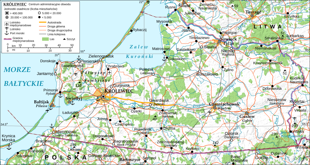
| Description | General map of the Kaliningrad Oblast, Russian Federation, with Polish names: main and variant exonyms (given in italics) established by the Commission on Standardization of Geographical Names Outside the Republic of Poland. Made with 3DEM, GRASS GIS, The Gimp and Inkscape software from public-domain GIS data (SRTM3, VMAP0). The relief shading is embedded bitmap graphics. Projection: UTM. Geodetic datum: Wgs84. Additional references: 1. Wikipedia Kaliningrad Oblast related articles and lists; 2. the 'Great Road Atlas of Europe', Freytag&Berndt u. Artaria KG, Vienna 2007; 3. Soviet military topographic maps (scale 1:500.000) - http://maps.poehali.org/en/. Use the other version of this file for translations. |
| Date | (UTC) |
| Source |
This file was derived from: KALININGRAD FINAL.svg: |
| Author |
|
| This is a retouched picture, which means that it has been digitally altered from its original version. Modifications: Polish transcription and in part translation, addition of variant exonyms (in italics).. The original can be viewed here: KALININGRAD FINAL.svg:
|
Licensing
[edit]
I, the copyright holder of this work, hereby publish it under the following licenses:
This file is licensed under the Creative Commons Attribution-Share Alike 3.0 Unported license.
- You are free:
- to share – to copy, distribute and transmit the work
- to remix – to adapt the work
- Under the following conditions:
- attribution – You must give appropriate credit, provide a link to the license, and indicate if changes were made. You may do so in any reasonable manner, but not in any way that suggests the licensor endorses you or your use.
- share alike – If you remix, transform, or build upon the material, you must distribute your contributions under the same or compatible license as the original.

|
Permission is granted to copy, distribute and/or modify this document under the terms of the GNU Free Documentation License, Version 1.2 or any later version published by the Free Software Foundation; with no Invariant Sections, no Front-Cover Texts, and no Back-Cover Texts. A copy of the license is included in the section entitled GNU Free Documentation License. |
You may select the license of your choice.
Original upload log
[edit]
This image is a derivative work of the following images:
- File:KALININGRAD FINAL.svg licensed with Cc-by-sa-3.0, GFDL
- 2009-04-16T06:06:13Z Andrein 1424x759 (4546759 Bytes) 1
- 2009-04-16T05:55:22Z Andrein 1424x759 (2781301 Bytes) 1
- 2009-04-01T10:25:57Z Andrein 1424x759 (4545652 Bytes) 1
- 2009-04-01T01:48:24Z Andrein 1424x759 (4569969 Bytes) 1
- 2009-04-01T00:49:47Z Andrein 1424x759 (4571046 Bytes) 1
- 2009-04-01T00:15:04Z Andrein 1424x759 (4571030 Bytes) 2
- 2009-03-31T23:51:20Z Andrein 1424x759 (4571284 Bytes) 2
- 2009-03-31T23:49:12Z Andrein 1424x759 (4551825 Bytes) 1
- 2009-03-31T23:45:03Z Andrein 1424x759 (4530581 Bytes) 1
- 2009-03-31T23:29:34Z Andrein 1424x759 (4528686 Bytes) 1
- 2009-03-31T23:09:13Z Andrein 1424x759 (4536239 Bytes) 1
- 2009-03-31T23:06:11Z Andrein 1424x759 (3291869 Bytes) {{Information |Description={{en|1=General map of the Kaliningrad Oblast.}} |Source=Own work by uploader |Author=[[User:Andrein|Andrein]] |Date=03.2009 |Permission=see below |other_versions= }} [[Category:Maps of Russia]] [[
Uploaded with derivativeFX
File history
Click on a date/time to view the file as it appeared at that time.
| Date/Time | Thumbnail | Dimensions | User | Comment | |
|---|---|---|---|---|---|
| current | 19:37, 20 May 2023 | | 1,424 × 759 (3.16 MB) | SparrowhawkM (talk | contribs) | Zmiana nazwy Kaliningrad na Królewiec według zaleceń KSNG |
| 11:44, 11 December 2022 |  | 1,424 × 759 (3.16 MB) | YazJazz (talk | contribs) | == {{int:filedesc}} == {{Information |Description=General map of the Kaliningrad Oblast, Russian Federation, with Polish names: main and variant exonyms (given in italics) established by the Commission on Standardization of Geographical Names Outside the Republic of Poland. Made with 3DEM, GRASS GIS, The Gimp and Inkscape software from public-domain GIS data (SRTM3, VMAP0). The relief shading is embedded bitmap... |
You cannot overwrite this file.
File usage on Commons
There are no pages that use this file.
File usage on other wikis
The following other wikis use this file:
- Usage on pl.wikipedia.org