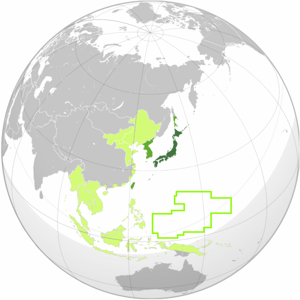
File:Japanese empire.png
From Wikimedia Commons, the free media repository
Jump to navigation
Jump to search

Size of this preview: 600 × 600 pixels. Other resolutions: 240 × 240 pixels | 480 × 480 pixels | 1,004 × 1,004 pixels.
Original file (1,004 × 1,004 pixels, file size: 277 KB, MIME type: image/png)
File information
Structured data
Captions
Captions
Add a one-line explanation of what this file represents

|
File:Japanese Empire (orthographic projection).svg is a vector version of this file. It should be used in place of this PNG file when not inferior.
File:Japanese empire.png → File:Japanese Empire (orthographic projection).svg
For more information, see Help:SVG.
|
Summary
[edit]| DescriptionJapanese empire.png |
English: Map of the Empire of Japan, based on File:Greater Japanese empire.png with contemporary borders. Okinawa and Chishima (Kurils) are marked as a part of Japan proper.
日本語: 大日本帝国の地図
한국어: 일본 제국의 지도
中文(臺灣):大日本帝國的地圖
Русский: Карта Японской империи
Français : Carte de l'Empire du Japon |
| Date | |
| Source | File:Greater Japanese empire.png, modified by Elmor |
| Author | Elmor |
Licensing
[edit]I, the copyright holder of this work, hereby publish it under the following license:
| This file is made available under the Creative Commons CC0 1.0 Universal Public Domain Dedication. | |
| The person who associated a work with this deed has dedicated the work to the public domain by waiving all of their rights to the work worldwide under copyright law, including all related and neighboring rights, to the extent allowed by law. You can copy, modify, distribute and perform the work, even for commercial purposes, all without asking permission.
http://creativecommons.org/publicdomain/zero/1.0/deed.enCC0Creative Commons Zero, Public Domain Dedicationfalsefalse |
File history
Click on a date/time to view the file as it appeared at that time.
| Date/Time | Thumbnail | Dimensions | User | Comment | |
|---|---|---|---|---|---|
| current | 09:53, 12 August 2011 |  | 1,004 × 1,004 (277 KB) | Elmor (talk | contribs) | India-Pakistan border removed |
| 09:22, 11 August 2011 |  | 1,004 × 1,004 (278 KB) | Elmor (talk | contribs) | border corrections | |
| 09:05, 11 August 2011 |  | 1,004 × 1,004 (278 KB) | Elmor (talk | contribs) | {{Information |Description ={{en|1=Map of the Empire of Japan, based on File:Greater Japanese empire.png with contemporary borders. Okinawa and Chishima (Kurils) are marked as a part of Japan proper.}} {{ja|1=大日本帝国の地図}} {{ko|1=일� |
You cannot overwrite this file.
File usage on Commons
There are no pages that use this file.
File usage on other wikis
The following other wikis use this file:
- Usage on ja.wikipedia.org
- Usage on mr.wikipedia.org
- Usage on zh.wikipedia.org
