File:India map mod.png
From Wikimedia Commons, the free media repository
Jump to navigation
Jump to search
India_map_mod.png (324 × 351 pixels, file size: 17 KB, MIME type: image/png)
File information
Structured data
Captions
Captions
Add a one-line explanation of what this file represents
This image was copied from wikipedia:de. The original description was:

|
Permission is granted to copy, distribute and/or modify this document under the terms of the GNU Free Documentation License, Version 1.2 or any later version published by the Free Software Foundation; with no Invariant Sections, no Front-Cover Texts, and no Back-Cover Texts. A copy of the license is included in the section entitled GNU Free Documentation License.http://www.gnu.org/copyleft/fdl.htmlGFDLGNU Free Documentation Licensetruetrue |
| This file is licensed under the Creative Commons Attribution-Share Alike 3.0 Unported license. | ||
| ||
| This licensing tag was added to this file as part of the GFDL licensing update.http://creativecommons.org/licenses/by-sa/3.0/CC BY-SA 3.0Creative Commons Attribution-Share Alike 3.0truetrue |
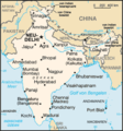
map of india modified
the frontier disputes of china and india is show in this map. the Aksai Chin is administrated by china, claimed by india; the most territories of Arunachal Pradesh is claimed by china and administrated by india. sassdads
| date/time | username | edit summary |
|---|---|---|
| 12:22, 21. Nov 2005 | Aka | (Änderungen von <a href="/w/index.php?title=Benutzer:84.191.254.164&action=edit" class="new" title="Benutzer:84.191.254.164">Benutzer:84.191.254.164</a> rückgängig gemacht und letzte Version von <a href="/w/index.php?title=Benutzer:193.170.142.18&action=edit" class="new" title="Benutzer:193.170.142.18">Benutzer:193.170.142.18</a> wiederhergestellt) |
| 12:22, 21. Nov 2005 | 84.191.254.164 | (indien) |
| 11:16, 14. Nov 2005 | 193.170.142.18 | |
| 09:59, 25. Apr 2005 | Lkkity | |
| 08:48, 25. Apr 2005 | Lkkity | ({{GFDL}} map of india modified) |
File history
Click on a date/time to view the file as it appeared at that time.
| Date/Time | Thumbnail | Dimensions | User | Comment | |
|---|---|---|---|---|---|
| current | 01:53, 14 March 2011 |  | 324 × 351 (17 KB) | Ras67 (talk | contribs) | cropped |
| 12:31, 23 May 2007 |  | 330 × 355 (22 KB) | Jungpionier (talk | contribs) | ||
| 06:11, 13 April 2007 |  | 330 × 355 (23 KB) | Elya (talk | contribs) | update Bengaluru/Bangalore | |
| 09:33, 4 August 2006 |  | 330 × 355 (22 KB) | Jungpionier (talk | contribs) | Tuttukkudi und Kozhikode entfernt | |
| 14:53, 3 August 2006 |  | 330 × 355 (23 KB) | Jungpionier (talk | contribs) | Marmagao und Kandla entfernt (zu unbedeutend); Jaipur ergänzt; Imphal durch Gauhati ersetzt | |
| 12:11, 3 August 2006 |  | 330 × 355 (23 KB) | Jungpionier (talk | contribs) | Bhubaneshwar ergänzt | |
| 09:51, 3 August 2006 |  | 330 × 355 (23 KB) | Jungpionier (talk | contribs) | Haldia (falsche Lage, zu unbedeutend) entfernt, Patna eingefügt | |
| 12:50, 30 June 2006 |  | 330 × 355 (23 KB) | Jungpionier (talk | contribs) | ||
| 10:17, 11 January 2006 |  | 330 × 355 (21 KB) | Tzzzpfff~commonswiki (talk | contribs) | Städte umbenannt, Schriften korrigiert, Meilenmaßstab entfernt | |
| 14:35, 20 December 2005 |  | 330 × 355 (24 KB) | Chnodomar~commonswiki (talk | contribs) | This image was copied from wikipedia:de. The original description was: {{GFDL}} map of india modified the frontier disputes of china and india is show in this map. the Aksai Chin is administrated by china, claimed by india; the most territories of Aruna |
You cannot overwrite this file.
File usage on Commons
There are no pages that use this file.
File usage on other wikis
The following other wikis use this file:
- Usage on af.wikipedia.org
- Usage on bar.wikipedia.org
- Usage on de.wikipedia.org
- Usage on de.wiktionary.org
- Usage on en.wikipedia.org
- Usage on eo.wikipedia.org
- Usage on frr.wikipedia.org
- Usage on ko.wikipedia.org
- Usage on kw.wikipedia.org
- Usage on la.wikipedia.org
- Usage on mi.wikipedia.org
- Usage on nl.wikipedia.org
- Usage on to.wikipedia.org
- Usage on zh.wikipedia.org
