File:Ibbenbueren Dreihasenstein 03.JPG
Jump to navigation
Jump to search

Size of this preview: 800 × 533 pixels. Other resolutions: 320 × 213 pixels | 640 × 427 pixels | 1,024 × 683 pixels | 1,280 × 853 pixels | 2,560 × 1,707 pixels | 5,472 × 3,648 pixels.
Original file (5,472 × 3,648 pixels, file size: 20.36 MB, MIME type: image/jpeg)
Captions
Captions
Add a one-line explanation of what this file represents
Summary
[edit]
| Description |
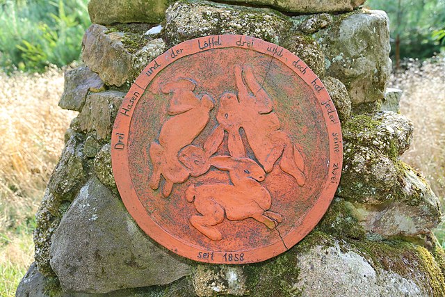
English: Detail of the Three Hares Stone (Dreihasenstein) in Ibbenbüren-Schierloh, Kreis Steinfurt, North Rhine-Westphalia, Germany. "Three hares and their three ears, and yet each has his two. Since 1858." This memorial stone is situated in the Teutoburg Forest.
Deutsch: Detailansicht des namengebenden Hasenreliefs des Dreihasensteins in Ibbenbüren-Schierloh, Kreis Steinfurt, Nordrhein-Westfalen, Deutschland. Die Inschrift lautet: „Drei Hasen und der Löffel drei und doch hat jeder seine zwei – seit 1858“. Der Gedenkstein befindet sich im Wald des Guts Grone (Teil des Teutoburger Waldes), unweit der Stadtgrenze zu Hörstel. |
| Date | |
| Source | Own work |
| Author | J.-H. Janßen |
| Camera location | | View this and other nearby images on: OpenStreetMap |
|---|
|
The photographical reproduction of this work is covered under the article § 59 of the German copyright law, which states that "It shall be permissible to reproduce, by painting, drawing, photography or cinematography, works which are permanently located on public ways, streets or places and to distribute and publicly communicate such copies. For works of architecture, this provision shall be applicable only to the external appearance."
As with all other “limits of copyright by legally permitted uses”, no changes to the actual work are permitted under § 62 of the German copyright law (UrhG). See Commons:Copyright rules by territory/Germany#Freedom of panorama for more information.
|
Licensing
[edit]
I, the copyright holder of this work, hereby publish it under the following license:
| This file is made available under the Creative Commons CC0 1.0 Universal Public Domain Dedication. | |
| The person who associated a work with this deed has dedicated the work to the public domain by waiving all of their rights to the work worldwide under copyright law, including all related and neighboring rights, to the extent allowed by law. You can copy, modify, distribute and perform the work, even for commercial purposes, all without asking permission.
|
File history
Click on a date/time to view the file as it appeared at that time.
| Date/Time | Thumbnail | Dimensions | User | Comment | |
|---|---|---|---|---|---|
| current | 20:04, 22 June 2016 | | 5,472 × 3,648 (20.36 MB) | J.-H. Janßen (talk | contribs) | {{Information |Description ={{en|1=Detail of the Three Hares Stone (''Dreihasenstein'') in Ibbenbüren-Schierloh, Kreis Steinfurt, North Rhine-Westphalia, Germany. This memorial stone is situated in the Teutoburg Forest.}} {{de|1=Det... |
You cannot overwrite this file.
File usage on Commons
There are no pages that use this file.
File usage on other wikis
The following other wikis use this file:
- Usage on en.wikipedia.org
- Usage on www.wikidata.org