File:Homicide rates per 100,000 by state. CDC. US map.svg
From Wikimedia Commons, the free media repository
Jump to navigation
Jump to search

Size of this PNG preview of this SVG file: 512 × 341 pixels. Other resolutions: 320 × 213 pixels | 640 × 426 pixels | 1,024 × 682 pixels | 1,280 × 853 pixels | 2,560 × 1,705 pixels.
Original file (SVG file, nominally 512 × 341 pixels, file size: 53 KB)
File information
Structured data
Captions
Captions
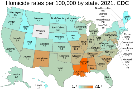
Homicide rates per 100,000 by state. US map
This image should always reflect the most recent version. Feel free to update it when needed.
|
Any autoconfirmed user can overwrite this file from the same source. Please ensure that overwrites comply with the guideline.
Summary
[edit]| DescriptionHomicide rates per 100,000 by state. CDC. US map.svg |
English: Homicide rates per 100,000 by state. US map. CDC. Centers for Disease Control and Prevention. See: List of U.S. states and territories by intentional homicide rate. D.C. is specifically not included because it is a federal district consisting of the city of Washington D.C.. Being a city, its much higher murder rate skews the 50-state spread for the states. |
| Date | - date of first upload to the Commons. See file history for later upload dates. |
| Source | Data from Homicide Mortality by State. National Center for Health Statistics. Centers for Disease Control and Prevention. N/A states: New Hampshire. Vermont. Wyoming. |
| Author | Timeshifter from template: File:Template map of US states and District of Columbia.svg. See instructions: File talk:Template map of US states and District of Columbia.svg/Instructions. |
| Other versions | FBI: File:Homicide rates per 100,000 by state. FBI. US map.svg |
Licensing
[edit]| Public domainPublic domainfalsefalse |
| This map is ineligible for copyright and therefore in the public domain, because it consists entirely of information that is common property and contains no original authorship. For more information, see Commons:Threshold of originality § Maps.
English | Español | Galego | Română | slovenščina | العربية | 简体中文 | 繁體中文 | +/− |
File history
Click on a date/time to view the file as it appeared at that time.
| Date/Time | Thumbnail | Dimensions | User | Comment | |
|---|---|---|---|---|---|
| current | 16:40, 5 March 2024 |  | 512 × 341 (53 KB) | Timeshifter (talk | contribs) | No DC number. Map made with new template. |
| 09:27, 24 July 2023 |  | 512 × 341 (46 KB) | Timeshifter (talk | contribs) | Per talk: Removed DOCTYPE line. Added: <svg version="1.1"... Changed class="name" to class="state". font-family="Liberation Sans,Arial,Helvetica,sans-serif". Text sizes: 40-30-17-17px | |
| 19:33, 4 July 2023 |  | 512 × 341 (46 KB) | Timeshifter (talk | contribs) | Added DC number to map. | |
| 18:24, 4 July 2023 |  | 512 × 341 (46 KB) | Timeshifter (talk | contribs) | Uploaded own work with UploadWizard |
You cannot overwrite this file.
File usage on Commons
The following 7 pages use this file:
- User:Magog the Ogre/Multilingual legend/2024 March 5-8
- File:Homicide rates per 100,000 by state. US map.svg (file redirect)
- File talk:Police killings in the USA in 2018.svg
- File talk:Template map of U.S. states and District of Columbia.svg/Instructions
- File talk:Template map of US states and District of Columbia.svg/Instructions
File usage on other wikis
The following other wikis use this file:
Metadata
This file contains additional information such as Exif metadata which may have been added by the digital camera, scanner, or software program used to create or digitize it. If the file has been modified from its original state, some details such as the timestamp may not fully reflect those of the original file. The timestamp is only as accurate as the clock in the camera, and it may be completely wrong.
| Short title | Homicide rates per 100,000 by state. 2021. CDC |
|---|---|
| Image title | Homicide rates per 100,000 by state. 2021. CDC |
| Width | 100% |
| Height | 100% |