File:Helsinki suurpiirit ja kaupunginosat.png
From Wikimedia Commons, the free media repository
Jump to navigation
Jump to search
Helsinki_suurpiirit_ja_kaupunginosat.png (567 × 502 pixels, file size: 19 KB, MIME type: image/png)
File information
Structured data
Captions
Captions
Add a one-line explanation of what this file represents

|
File:Helsinki-Helsingfors.suurpiirit-stordistrikt.svg is a vector version of this file. It should be used in place of this PNG file when not inferior.
File:Helsinki suurpiirit ja kaupunginosat.png → File:Helsinki-Helsingfors.suurpiirit-stordistrikt.svg
For more information, see Help:SVG.
|
Summary
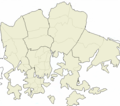
[edit]Map showing Helsinki's seven major districts (suurpiirit) and 54 minor districts (kaupunginosat).
Source: Self-made, based on Image:Helsinki districts2.png
Date: 2006-07-10
Author: BishkekRocks
Licensing
[edit]| Public domainPublic domainfalsefalse |
| I, the copyright holder of this work, release this work into the public domain. This applies worldwide. In some countries this may not be legally possible; if so: I grant anyone the right to use this work for any purpose, without any conditions, unless such conditions are required by law. |
| Annotations InfoField | This image is annotated: View the annotations at Commons |
253
101
199
123
567
502
Ainakin Malmin ja Mellunkylän kaupunginosien raja on tässä väärin - tämän mukaan Kivikko kuuluisi Malmiin.
There are some errors in the map - according to this, Kivikko is part of Malmi instead of Mellunkylä, which is not the case.
File history
Click on a date/time to view the file as it appeared at that time.
| Date/Time | Thumbnail | Dimensions | User | Comment | |
|---|---|---|---|---|---|
| current | 13:08, 10 July 2006 |  | 567 × 502 (19 KB) | BishkekRocks (talk | contribs) | Map showing Helsinki's seven major districts (''suurpiirit'') and 54 minor districts (''kaupunginosat''). Source: Self-made, based on Image:Helsinki districts2.png Date: 2006-07-10 Author: ~~~ Category:Helsinki district location maps |
You cannot overwrite this file.
File usage on Commons
There are no pages that use this file.

