File:Hagen, Steinbruch Donnerkuhle.JPG
Jump to navigation
Jump to search

Size of this preview: 800 × 566 pixels. Other resolutions: 320 × 227 pixels | 640 × 453 pixels | 1,024 × 725 pixels | 1,280 × 906 pixels | 2,560 × 1,812 pixels | 4,000 × 2,832 pixels.
Original file (4,000 × 2,832 pixels, file size: 3.77 MB, MIME type: image/jpeg)
Captions
Captions
Add a one-line explanation of what this file represents
Summary
[edit]
| Description |
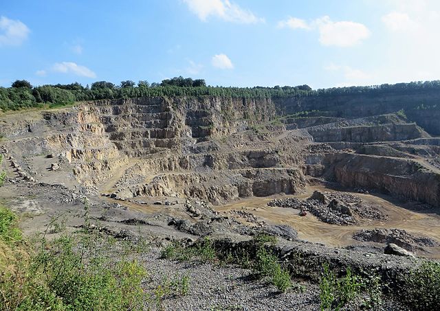
Deutsch: Steinbruch Donnerkuhle der Rheinkalk GmbH (Lhoist-Gruppe) in Hagen. Der nördliche Aussichtspunkt (Foto) ist über einen Seitenweg der Hohenlimburger Straße (B 7) erreichbar. Im Steinbruch Donnerkuhle wird schon seit Beginn des 20. Jahrhunderts dolomitischer Kalkstein abgebaut. Die Fläche des Steinbruchs beträgt rund 67 ha. Seine Vertiefung wurde 2011 bis zu einem Niveau von +42 m NHN genehmigt. Die Donnerkuhle ist ein in Deutschland einzigartiges Rohstoffvorkommen und liegt am Nordrand eines Massenkalkvorkommens von bis zu 600 Meter Mächtigkeit, das vor etwa 370 Millionen Jahren im höheren Mitteldevon gebildet wurde. Der abgebildete Bereich liegt im Landschaftsschutzgebiet „Hassley“ und wird im Osten vom Naturschutzgebiet „Temporärer Mastberg“ (Foto: links oberhalb der Steinbruchkante), im Westen vom Naturschutzgebiet „Ochsenkamp“ begrenzt. |
| Date | |
| Source | Own work |
| Author | Bärwinkel,Klaus |
Licensing
[edit]
I, the copyright holder of this work, hereby publish it under the following licenses:

|
Permission is granted to copy, distribute and/or modify this document under the terms of the GNU Free Documentation License, Version 1.2 or any later version published by the Free Software Foundation; with no Invariant Sections, no Front-Cover Texts, and no Back-Cover Texts. A copy of the license is included in the section entitled GNU Free Documentation License. |
This file is licensed under the Creative Commons Attribution 3.0 Unported license.
- You are free:
- to share – to copy, distribute and transmit the work
- to remix – to adapt the work
- Under the following conditions:
- attribution – You must give appropriate credit, provide a link to the license, and indicate if changes were made. You may do so in any reasonable manner, but not in any way that suggests the licensor endorses you or your use.
You may select the license of your choice.
File history
Click on a date/time to view the file as it appeared at that time.
| Date/Time | Thumbnail | Dimensions | User | Comment | |
|---|---|---|---|---|---|
| current | 08:58, 14 August 2016 | | 4,000 × 2,832 (3.77 MB) | Bärwinkel,Klaus (talk | contribs) | {{Information |Description ={{de|1=Steinbruch Donnerkuhle der Rheinkalk GmbH in Hagen, Hohenlimburger Straße. Im Steinbruch Donnerkuhle wird schon seit Beginn des 20. Jahrhunderts dolomitischer Kalkstein abgebaut. Die Vertiefung des Steinbruche... |
You cannot overwrite this file.
File usage on Commons
The following 2 pages use this file:
File usage on other wikis
The following other wikis use this file:
- Usage on de.wikipedia.org
- Usage on www.wikidata.org