File:Guinea Bissau regions named.png
Jump to navigation
Jump to search
No higher resolution available.
Guinea_Bissau_regions_named.png (400 × 236 pixels, file size: 13 KB, MIME type: image/png)
Captions
Captions
Add a one-line explanation of what this file represents

|
This map image could be re-created using vector graphics as an SVG file. This has several advantages; see Commons:Media for cleanup for more information. If an SVG form of this image is available, please upload it and afterwards replace this template with
{{vector version available|new image name}}.
It is recommended to name the SVG file “Guinea Bissau regions named.svg”—then the template Vector version available (or Vva) does not need the new image name parameter. |
| Description |
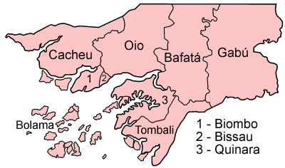
Map of the regions of Guinea-Bissau, named in Portuguese (native language), compatible with English. Individual maps are: |
| Date | |
| Source | Own work (Original text: Self-made, traced from public domain UN or CIA maps.) |
| Author | User:Golbez |
| Permission (Reusing this file) |
Provide attribution, please. See below. |
Licensing
[edit]
User:Golbez, the copyright holder of this work, hereby publishes it under the following licenses:
This file is licensed under the Creative Commons Attribution-Share Alike 2.5 Generic, 2.0 Generic and 1.0 Generic license.
Attribution: User:Golbez
- You are free:
- to share – to copy, distribute and transmit the work
- to remix – to adapt the work
- Under the following conditions:
- attribution – You must give appropriate credit, provide a link to the license, and indicate if changes were made. You may do so in any reasonable manner, but not in any way that suggests the licensor endorses you or your use.
- share alike – If you remix, transform, or build upon the material, you must distribute your contributions under the same or compatible license as the original.

|
Permission is granted to copy, distribute and/or modify this document under the terms of the GNU Free Documentation License, Version 1.2 or any later version published by the Free Software Foundation; with no Invariant Sections, no Front-Cover Texts, and no Back-Cover Texts. A copy of the license is included in the section entitled GNU Free Documentation License. |
| This file is licensed under the Creative Commons Attribution-Share Alike 3.0 Unported license. | ||
| Attribution: User:Golbez | ||
| ||
| This licensing tag was added to this file as part of the GFDL licensing update. |
You may select the license of your choice.
File history
Click on a date/time to view the file as it appeared at that time.
| Date/Time | Thumbnail | Dimensions | User | Comment | |
|---|---|---|---|---|---|
| current | 09:31, 27 June 2005 | | 400 × 236 (13 KB) | Golbez (talk | contribs) | Map of the regions of Guinea Bissau. Source: Made by User:Golbez. {{cc-by-sa-2.0}} Category:Maps of Guinea Bissau\ |
You cannot overwrite this file.
File usage on Commons
The following 2 pages use this file:
File usage on other wikis
The following other wikis use this file:
- Usage on af.wikipedia.org
- Usage on be-tarask.wikipedia.org
- Usage on bg.wikipedia.org
- Usage on br.wikipedia.org
- Usage on ca.wikipedia.org
- Guinea Bissau
- Bissau
- Safim
- Regió de Bolama
- Bolama
- Cacheu
- Regions de Guinea Bissau
- Plantilla:Regions de Guinea Bissau
- Regió de Bafatá
- Regió de Gabú
- Regió de Biombo
- Regió d'Oio
- Regió de Cacheu
- Regió de Quinara
- Regió de Tombali
- Sectors de Guinea Bissau
- Bafatá
- Bambadinca
- Contuboel
- Galomaro
- Gamamundo
- Xitole
- Madina do Boé
- Pirada
- Pitche
- Sonaco
- Gabú
- Quinhámel
- Bigene
- Bula (Guinea Bissau)
- Caió
- Canghungo
- São Domingos (Guinea Bissau)
- Bissorã
- Farim
- Mansabá
- Mansôa
- Nhacra
- Empada
- Fulacunda
- Tite
- Buba
- Cacine
- Bedanda
- Quebo
View more global usage of this file.