File:Grenzkarte Münster-Geldern bei Burlo, Claessen & van Hasselt, Kopie 1769.png
Jump to navigation
Jump to search
Size of this preview: 800 × 576 pixels. Other resolutions: 320 × 230 pixels | 640 × 461 pixels | 1,024 × 737 pixels | 1,280 × 921 pixels | 2,560 × 1,843 pixels | 4,852 × 3,493 pixels.
Original file (4,852 × 3,493 pixels, file size: 18.95 MB, MIME type: image/png)
Captions
Captions
Add a one-line explanation of what this file represents
| Description |
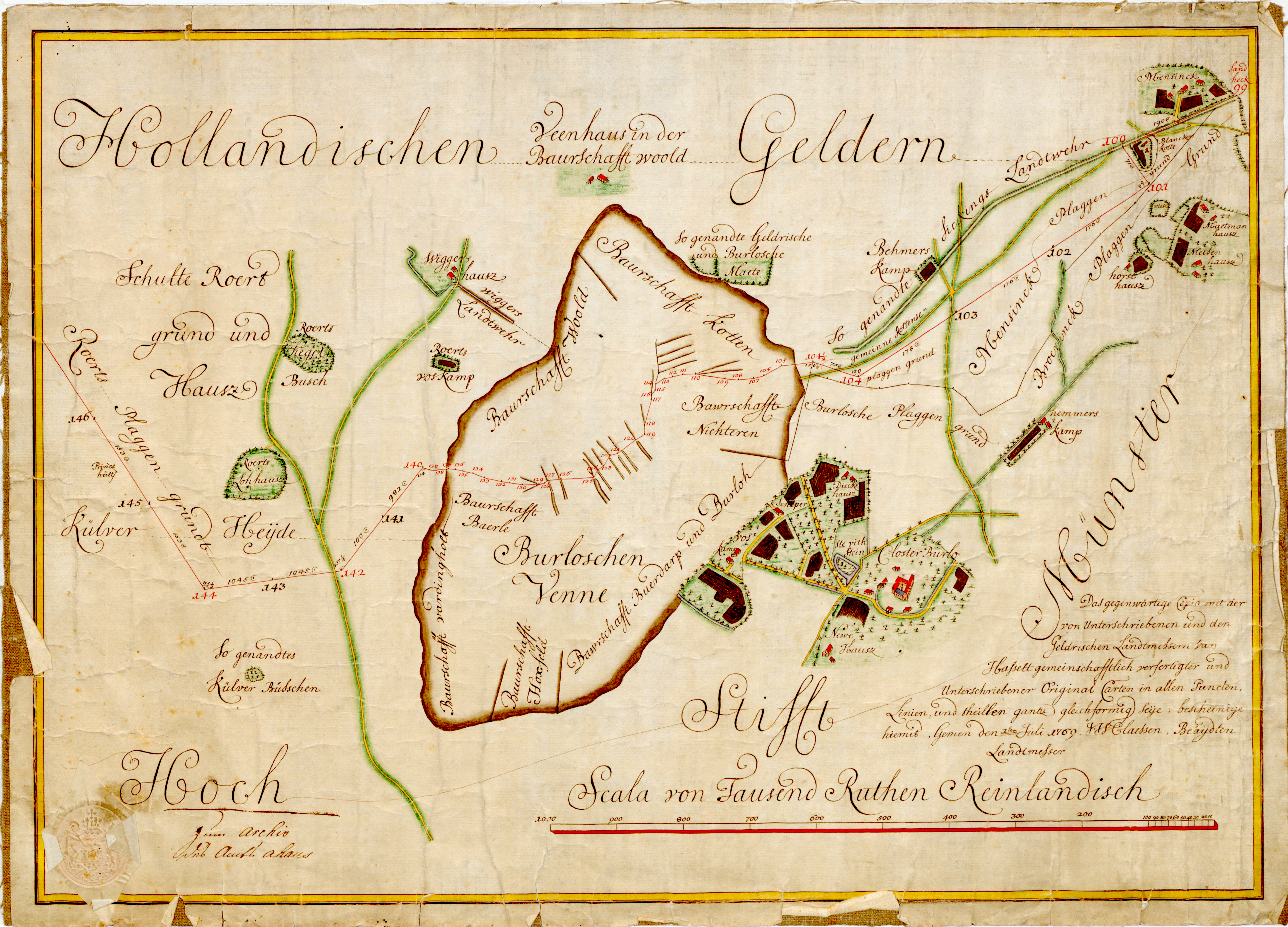
Deutsch: Karte der Grenzfestlegung gemäß Burloer Konvention vom 19. Oktober 1765 zwischen dem Herzogtum Geldern als Provinz der Vereinigten Niederlande und dem Fürstbistums Münster im Bereich des Tagungsortes Burlo. Die Karte umfasst den Bereich vom Sandheck bei Oeding (Stein Nr. 99) bis zur Külver Heide bei Barlo (Stein Nr. 146). Fürstensteine mit eingeschlagenen Wappen von Münster und Geldern sind in roter Schrift eingetragen, Lettersteine, die lediglich die Buchstaben M(ünster) und G(eldern) tragen, sind mit schwarzer Nummer versehen.
Die Karte wurde 1769 vom fürstbischöflichen Landvermesser J. H. Claessen als Kopie einer Originalkarte erstellt, die er 1765/66 zusammen mit seinem geldrischen Kollegen J. G. J. van Hasselt erstellt hatte. Das Original befindet sich im Landesarchiv Nordrhein-Westfalen Abteilung Westfalen in Münster (LAV NRW W, Karten A Nr. 3720).English: Map of the boundary between Prince-Bishopric of Münster and Guelders as it was established in Burlo (today city of Borken in Westphalia) on 10/19/1765. |
||||
| Date | |||||
| Source | Landesarchiv Nordrhein-Westfalen Abteilung Westfalen, Münster (online verfügbar unter LAV NRW W, Karten A Nr. 3720) | ||||
| Author |
Johan Henrich Claessen (Landmesser des Fürstbistums Münster), |
||||
| Permission (Reusing this file) |
|
||||
| Annotations | This image is annotated: View the annotations at Commons |
File history
Click on a date/time to view the file as it appeared at that time.
| Date/Time | Thumbnail | Dimensions | User | Comment | |
|---|---|---|---|---|---|
| current | 11:26, 14 July 2015 | | 4,852 × 3,493 (18.95 MB) | Watzmann (talk | contribs) | {{Information |Description ={{en|1=Map of the boundary between Prince-Bishopric of Münster and Guelders as it was established in Burlo (today city of Borken in Westphalia) on 10/19/1765.}} {{de|... |
You cannot overwrite this file.
File usage on Commons
There are no pages that use this file.
File usage on other wikis
The following other wikis use this file: