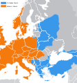
File:Great Schism 1054.svg
From Wikimedia Commons, the free media repository
Jump to navigation
Jump to search

Size of this PNG preview of this SVG file: 560 × 599 pixels. Other resolutions: 224 × 240 pixels | 448 × 480 pixels | 717 × 768 pixels | 957 × 1,024 pixels | 1,913 × 2,048 pixels | 1,106 × 1,184 pixels.
Original file (SVG file, nominally 1,106 × 1,184 pixels, file size: 1.2 MB)
File information
Structured data
Captions
Captions
Add a one-line explanation of what this file represents
| DescriptionGreat Schism 1054.svg |
English: A map showing today's national boundaries and eastern/western allegiances in 1054. |
| Date | In this from: 2010-07-27 |
| Source | Derived from http://en.wikipedia.org/wiki/File:Great_Schism_1054.gif, Felix the Cassowary derived me from Wikipedia:User:Milan studio's map created from [1] (source that showing dominant religions on the state level), Wikipedia Europe SVG map. |
| Author | Cassowary, wikipedia:user:milan studio |

|
Permission is granted to copy, distribute and/or modify this document under the terms of the GNU Free Documentation License, Version 1.2 or any later version published by the Free Software Foundation; with no Invariant Sections, no Front-Cover Texts, and no Back-Cover Texts. A copy of the license is included in the section entitled GNU Free Documentation License.http://www.gnu.org/copyleft/fdl.htmlGFDLGNU Free Documentation Licensetruetrue |
File history
Click on a date/time to view the file as it appeared at that time.
| Date/Time | Thumbnail | Dimensions | User | Comment | |
|---|---|---|---|---|---|
| current | 15:36, 28 August 2021 |  | 1,106 × 1,184 (1.2 MB) | Kun Kipcsak (talk | contribs) | Reverted to version as of 23:41, 17 September 2011 (UTC) Revert vandal |
| 08:06, 18 September 2011 |  | 2,000 × 2,141 (643 KB) | Iaaasi (talk | contribs) | ew version of File:Great Schism 1054.svg: minor correction according to Dragan Brujić, Vodič kroz svet Vizantije, Beograd, 2004, page 51. (publishers: DINA - Beograd and RADIONICA - Pancevo) - if someone needs to check the scanned original map, please c | |
| 23:41, 17 September 2011 |  | 1,106 × 1,184 (1.2 MB) | Fakirbakir (talk | contribs) | Reverted to version as of 09:30, 27 July 2010, please, Do not manipulate this map, | |
| 12:38, 17 September 2011 |  | 2,000 × 2,141 (643 KB) | Iaaasi (talk | contribs) | minor correction according to Dragan Brujić, Vodič kroz svet Vizantije, Beograd, 2004, page 51. (publishers: DINA - Beograd and RADIONICA - Pancevo) - if someone needs to check the scanned original map from this historical atlas, please contact me | |
| 09:30, 27 July 2010 |  | 1,106 × 1,184 (1.2 MB) | Cassowary (talk | contribs) | {{Information |Description={{en|1=I am a map showing ''today's'' national boundaries and eastern/western allegiances in 1054.}} |Source=Derived from http://en.wikipedia.org/wiki/File:Great_Schism_1054.gif |Author=Cassowary, [[wikipedia: |
You cannot overwrite this file.
File usage on Commons
The following page uses this file:
File usage on other wikis
The following other wikis use this file:
- Usage on ka.wikipedia.org
Metadata
This file contains additional information such as Exif metadata which may have been added by the digital camera, scanner, or software program used to create or digitize it. If the file has been modified from its original state, some details such as the timestamp may not fully reflect those of the original file. The timestamp is only as accurate as the clock in the camera, and it may be completely wrong.
| Width | 1105.9841 |
|---|---|
| Height | 1183.7102 |