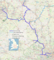
File:Grand Union Canal, complete system map.png

Original file (1,380 × 1,555 pixels, file size: 3.29 MB, MIME type: image/png)
Captions
Captions
Summary
[edit]| DescriptionGrand Union Canal, complete system map.png |
Map of the complete system of the Grand Union Canal, including all significant arms and branches. This map was created from OpenStreetMap project data, collected by the community. This map may be incomplete, and may contain errors. Don't rely solely on it for navigation. |
|||
| Date | ||||
| Source | openstreetmap.org | |||
| Creator |
Own work, derived from open street map. OpenStreetMap contributors |
|||
| Permission (Reusing this file) |
OpenStreetMap data is available under the Open Database License (details). Standard style map tiles are licensed as ODbL Produced Works.
|
|||
| Georeferencing | Georeference the map in Wikimaps Warper If inappropriate please set warp_status = skip to hide. |
File history
Click on a date/time to view the file as it appeared at that time.
| Date/Time | Thumbnail | Dimensions | User | Comment | |
|---|---|---|---|---|---|
| current | 14:56, 4 May 2022 |  | 1,380 × 1,555 (3.29 MB) | G-13114 (talk | contribs) | various small improvements |
| 09:44, 4 May 2022 |  | 1,380 × 1,555 (3.29 MB) | G-13114 (talk | contribs) | add locator map | |
| 23:34, 26 April 2022 |  | 1,380 × 1,555 (3.37 MB) | G-13114 (talk | contribs) | Tweaks | |
| 02:18, 26 April 2022 |  | 1,380 × 1,555 (3.37 MB) | G-13114 (talk | contribs) | Cropped with improvements | |
| 02:06, 26 April 2022 |  | 1,380 × 1,660 (3.61 MB) | G-13114 (talk | contribs) | {{OpenStreetMap |name = |location = |description = Map of the complete system of the Grand Union Canal, including all significant arms and branches. |top = |bottom = |left = |right = |date = 2022-04-26 |authors = Own work, derived from open street map. |other_versions = }} Category:OpenStreetMap maps of the West Midlands (region) Category:OpenStreetMap maps of Warwickshire Category:Maps produced by User:G-13114 Category:Grand Union Canal [[Category:OpenStreetMap maps... |
You cannot overwrite this file.
File usage on Commons
The following 4 pages use this file:
File usage on other wikis
The following other wikis use this file:
- Usage on en.wikipedia.org
- Usage on es.wikipedia.org
Metadata
This file contains additional information such as Exif metadata which may have been added by the digital camera, scanner, or software program used to create or digitize it. If the file has been modified from its original state, some details such as the timestamp may not fully reflect those of the original file. The timestamp is only as accurate as the clock in the camera, and it may be completely wrong.
| PNG file comment |
|
|---|---|
| Horizontal resolution | 28.35 dpc |
| Vertical resolution | 28.35 dpc |
| File change date and time | 14:54, 4 May 2022 |
