File:Geomap Muenchberg Massif.png
Jump to navigation
Jump to search

Size of this preview: 514 × 600 pixels. Other resolutions: 206 × 240 pixels | 411 × 480 pixels | 658 × 768 pixels | 877 × 1,024 pixels | 2,470 × 2,883 pixels.
Original file (2,470 × 2,883 pixels, file size: 1.99 MB, MIME type: image/png)
Captions
Captions
Add a one-line explanation of what this file represents
Summary
[edit]
| Description |
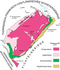
English: Simplified geological map of the Münchberg Massif, an exotic block of high to moderate metamorphic, late Proterozoic to early Paleozoic rocks, surrounded by lowest grade and unmetamorphosed Paleozoic rocks. Variscan fold belt of central Europe, northeastern Bavaria, Germany.
Deutsch: Vereinfachte geologische Karte der Münchberger Masse (Münchberger Gneismasse, Münchberger Gneisplatte), eine exotische Scholle mit hoch- bis mittelgradig metamorphen, spätproterozoisch bis frühpaläozoischen Gesteinen, umgeben von niedrigstgradig- und unmetamorphen paläozoischen Gesteinen. Variszischer Faltengürtel von Mitteleuropa, Nordost-Bayern. |
| Date | |
| Source | Own work |
| Author | Gretarsson |
Licensing
[edit]
I, the copyright holder of this work, hereby publish it under the following licenses:

|
Permission is granted to copy, distribute and/or modify this document under the terms of the GNU Free Documentation License, Version 1.2 or any later version published by the Free Software Foundation; with no Invariant Sections, no Front-Cover Texts, and no Back-Cover Texts. A copy of the license is included in the section entitled GNU Free Documentation License. |
This file is licensed under the Creative Commons Attribution-Share Alike 3.0 Unported, 2.5 Generic, 2.0 Generic and 1.0 Generic license.
- You are free:
- to share – to copy, distribute and transmit the work
- to remix – to adapt the work
- Under the following conditions:
- attribution – You must give appropriate credit, provide a link to the license, and indicate if changes were made. You may do so in any reasonable manner, but not in any way that suggests the licensor endorses you or your use.
- share alike – If you remix, transform, or build upon the material, you must distribute your contributions under the same or compatible license as the original.
You may select the license of your choice.
File history
Click on a date/time to view the file as it appeared at that time.
| Date/Time | Thumbnail | Dimensions | User | Comment | |
|---|---|---|---|---|---|
| current | 14:07, 19 October 2013 | | 2,470 × 2,883 (1.99 MB) | Gretarsson (talk | contribs) | {{Information |Description ={{en|1=Simplified geological map of the Münchberg Massif, an exotic block of high to moderate metamorphic, late proterozoic to early paleozoic rocks, surrounded by low grade and unmetamorphic paleozoic rocks. Variscan fo... |
You cannot overwrite this file.
File usage on Commons
The following page uses this file:
File usage on other wikis
The following other wikis use this file:
- Usage on de.wikipedia.org
- Usage on de.wikibooks.org
- Usage on fr.wikipedia.org