File:Fort Okfuskee.jpg
Jump to navigation
Jump to search

Size of this preview: 800 × 405 pixels. Other resolutions: 320 × 162 pixels | 640 × 324 pixels | 1,395 × 707 pixels.
Original file (1,395 × 707 pixels, file size: 185 KB, MIME type: image/jpeg)
Captions
Captions
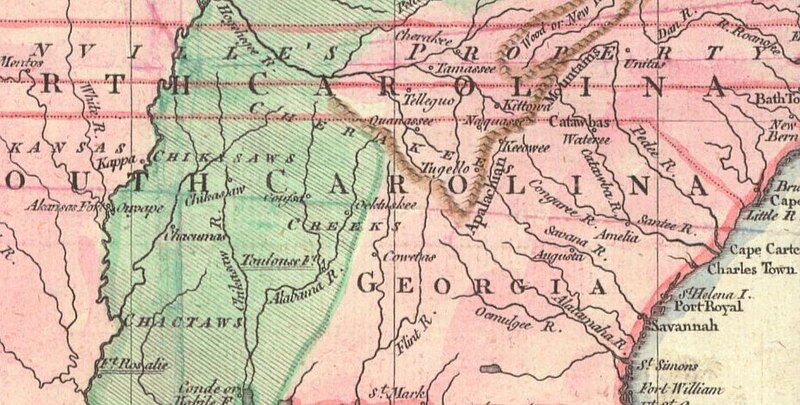
John Lodge 1754 map showing the location of Okfuskee (spelled Ockfuskee in center of image)
Summary
[edit]
| Description |
English: John Lodge 1754 map showing the location of Okfuskee (spelled Ockfuskee in center of image). Map shows the village located on the west side of the Tallapoosa River |
| Date | |
| Source | http://alabamamaps.ua.edu/historicalmaps/unitedstates/1751-1775.html |
| Author | John Lodge |
Licensing
[edit]
|
This work is in the public domain in its country of origin and other countries and areas where the copyright term is the author's life plus 70 years or fewer. This work is in the public domain in the United States because it was published (or registered with the U.S. Copyright Office) before January 1, 1929. | |
| This file has been identified as being free of known restrictions under copyright law, including all related and neighboring rights. | |
File history
Click on a date/time to view the file as it appeared at that time.
| Date/Time | Thumbnail | Dimensions | User | Comment | |
|---|---|---|---|---|---|
| current | 04:41, 20 March 2023 | | 1,395 × 707 (185 KB) | Dofftoubab (talk | contribs) | Uploaded a work by John Lodge from http://alabamamaps.ua.edu/historicalmaps/unitedstates/1751-1775.html with UploadWizard |
You cannot overwrite this file.
File usage on Commons
There are no pages that use this file.
File usage on other wikis
The following other wikis use this file:
- Usage on en.wikipedia.org
- Usage on www.wikidata.org
Metadata
Categories:
- 18th-century maps of Alabama
- John Lodge (engraver)
- Muscogee maps
- 1750s maps of Georgia (U.S. state)
- Cherokee maps
- Choctaw maps
- Chickasaw maps
- Tellico Blockhouse
- Catawba
- St. Marks, Florida
- Fort Rosalie
- Coweta (tribal town)
- Native American history of the 1750s
- 1750s maps of South Carolina
- 1750s maps of Tennessee
- Tanasi
- Great Tellico
- Arkansas Post
- Fort Toulouse and Fort Jackson