File:Fog in the Canadian Rockies (MODIS 2020-11-06).jpg
Jump to navigation
Jump to search

Size of this preview: 737 × 600 pixels. Other resolutions: 295 × 240 pixels | 590 × 480 pixels | 944 × 768 pixels | 1,258 × 1,024 pixels | 2,517 × 2,048 pixels | 2,808 × 2,285 pixels.
Original file (2,808 × 2,285 pixels, file size: 1.04 MB, MIME type: image/jpeg)
Captions
Captions
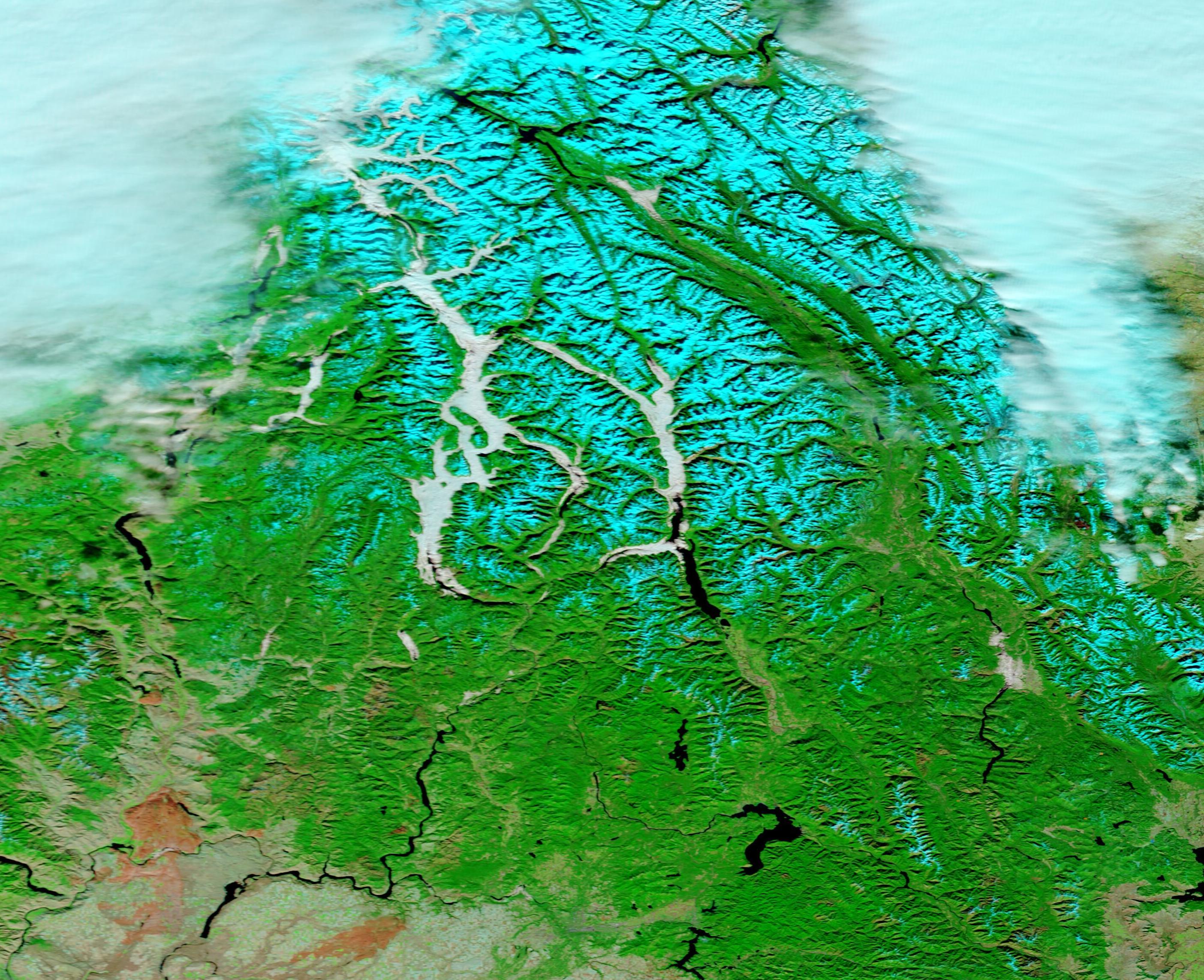
On November 2, 2020, the Moderate Resolution Imaging Spectroradiometer (MODIS) on board NASA’s Terra satellite acquired a false-color image of valley fog in British Columbia, Canada.
Summary
[edit].jpg&action=edit§ion=1)
| Description |
English: As autumn nights lengthen and cool weather settles over the mountains, the chances of valleys filling with evening fog increase. In the long night, the atmosphere has more time to cool down and approach the dew point—the temperature at which the air becomes saturated and water vapor condenses into fog. Since cold air is denser than warm air, it sinks into low-lying valleys, meaning fog develops there first, while the higher mountain peaks remain in clear air. When valleys are filled with rivers, streams, or lakes, the process is amplified as these features provide a ready supply of water vapor.
On November 2, 2020, the Moderate Resolution Imaging Spectroradiometer (MODIS) on board NASA’s Terra satellite acquired a false-color image of valley fog in British Columbia, Canada. This false-color image uses a combination of visible and infrared light to make it easier to distinguish between snow, fog, and cloud—all of which appear white in true-color images. In this combination, snow appears bright cyan, fog (low cloud) appears white, and higher, colder cloud appears pale cyan. The heaviest fog appears over lakes, including Upper Arrow Lake (east) and Okanagan Lake (west). |
||
| Date | Taken on 2 November 2020 | ||
| Source |
Fog in the Canadian Rockies (direct link)
|
||
| Author | MODIS Land Rapid Response Team, NASA GSFC |
| This media is a product of the Terra mission Credit and attribution belongs to the mission team, if not already specified in the "author" row |
Licensing
[edit].jpg&action=edit§ion=2)
| This file is in the public domain in the United States because it was solely created by NASA. NASA copyright policy states that "NASA material is not protected by copyright unless noted". (See Template:PD-USGov, NASA copyright policy page or JPL Image Use Policy.) | ||
 |
Warnings:
|
File history
Click on a date/time to view the file as it appeared at that time.
| Date/Time | Thumbnail | Dimensions | User | Comment | |
|---|---|---|---|---|---|
| current | 17:41, 4 February 2024 | | 2,808 × 2,285 (1.04 MB) | OptimusPrimeBot (talk | contribs) | #Spacemedia - Upload of http://modis.gsfc.nasa.gov/gallery/images/image11062020_250m.jpg via Commons:Spacemedia |
You cannot overwrite this file.
File usage on Commons
There are no pages that use this file.
.jpg&oldid=909384370)