File:Flooding in southern Iran ESA21798304.jpeg

Original file (2,850 × 2,400 pixels, file size: 1.19 MB, MIME type: image/jpeg)
Captions
Captions
Summary
[edit]| Description |
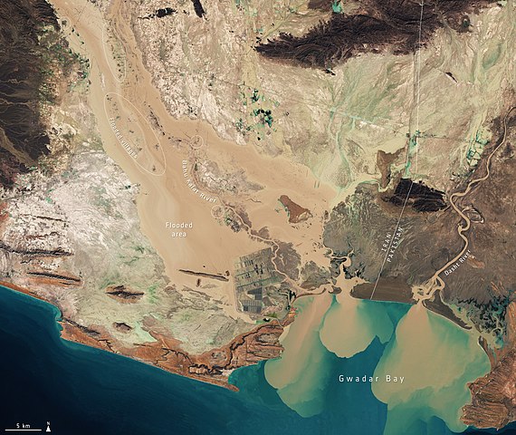
English: Heavy rainfall has triggered flooding in southern Iran, particularly in the Sistan and Baluchestan, Hormozgan and Kerman provinces. The downpour has led to blocked roads and destroyed bridges, crops and houses – displacing thousands of people. This image, captured by the Copernicus Sentinel-2 mission, shows the extent of the flooding in the Sistan and Baluchestan province on 13 January 2020. Flooded areas are visible in brown, while the flooded villages are highlighted by dotted circles. Sediment and mud, caused by the heavy rains, can be seen gushing from the Bahu Kalat River, Iran, and Dasht River, Pakistan, into Gwadar Bay. Zoom in to view the image of the floods at its full 10 m resolution. The flooding has also affected Zahedan, as well as Konarak, Saravan, Nik Shahr, Delgan, Bazman, Chabahar, Zarābād and Khash. In response to the flood, the Copernicus Emergency Mapping Service was activated. The service uses satellite observations to help civil protection authorities and, in cases of disaster, the international humanitarian community, respond to emergencies. |
| Date | Taken on 13 January 2020 |
| Source | Flooding in southern Iran |
| Author | European Space Agency |
| Other versions |
|
| Activity | Observing the Earth |
| Mission | Sentinel-2 |
| System | Copernicus |

Licensing
[edit]

|
This image contains data from a satellite in the Copernicus Programme, such as Sentinel-1, Sentinel-2 or Sentinel-3. Attribution is required when using this image.
Attribution: Contains modified Copernicus Sentinel data 2020
The use of Copernicus Sentinel Data is regulated under EU law (Commission Delegated Regulation (EU) No 1159/2013 and Regulation (EU) No 377/2014). Relevant excerpts:
Free access shall be given to GMES dedicated data [...] made available through GMES dissemination platforms [...].
Access to GMES dedicated data [...] shall be given for the purpose of the following use in so far as it is lawful:
GMES dedicated data [...] may be used worldwide without limitations in time.
GMES dedicated data and GMES service information are provided to users without any express or implied warranty, including as regards quality and suitability for any purpose. |
This media was created by the European Space Agency (ESA).
Where expressly so stated, images or videos are covered by the Creative Commons Attribution-ShareAlike 3.0 IGO (CC BY-SA 3.0 IGO) licence, ESA being an Intergovernmental Organisation (IGO), as defined by the CC BY-SA 3.0 IGO licence. The user is allowed under the terms and conditions of the CC BY-SA 3.0 IGO license to Reproduce, Distribute and Publicly Perform the ESA images and videos released under CC BY-SA 3.0 IGO licence and the Adaptations thereof, without further explicit permission being necessary, for as long as the user complies with the conditions and restrictions set forth in the CC BY-SA 3.0 IGO licence, these including that:
See the ESA Creative Commons copyright notice for complete information, and this article for additional details.
|
 | |
This file is licensed under the Creative Commons Attribution-ShareAlike 3.0 IGO license. Attribution: ESA, CC BY-SA IGO 3.0
| ||
File history
Click on a date/time to view the file as it appeared at that time.
| Date/Time | Thumbnail | Dimensions | User | Comment | |
|---|---|---|---|---|---|
| current | 14:20, 6 June 2020 | | 2,850 × 2,400 (1.19 MB) | OptimusPrimeBot (talk | contribs) | #Spacemedia - Upload of https://www.esa.int/var/esa/storage/images/esa_multimedia/images/2020/01/flooding_in_southern_iran/21798293-1-eng-GB/Flooding_in_southern_Iran.jpg via Commons:Spacemedia |
You cannot overwrite this file.
File usage on Commons
The following page uses this file:
File usage on other wikis
The following other wikis use this file:
- Usage on ar.wikipedia.org
- Usage on en.wikipedia.org
- Usage on uz.wikipedia.org