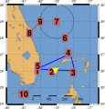
File:Flight 19 vector map.svg

Original file (SVG file, nominally 421 × 435 pixels, file size: 210 KB)
Captions
Captions
Summary
[edit]| DescriptionFlight 19 vector map.svg |
English: Vector map of Flight 19, 1945. |
| Date | |
| Source | Own work |
| Author | Merikanto |
| Camera location | 26° 07′ 58.8″ N, 80° 09′ 00″ W | View this and other nearby images on: OpenStreetMap |
|---|
This is Generic Mapping Tool unix bash shell script to generate this image.
- Vector map of Flight 19 disappearence 1945
- gmt 5.4 bash script, linux
- you need Inkscape to crop image from PDF, save SVG
- if there is problem with coordinates location in map,
- 1) convert .ps file to .pdf
- 2) crop .pdf, and rotate cropped image
- 3) convert cropped pdf to .svg (save svg in inkscape)
- !/bin/bash
- gmt gmtset BASEMAP_TYPE = fancy
rect=-82/-76.5/24/30
- rect=-80.5/-77.5/25.5/27.5
proj=Q10c
target=flight.ps
skale1=-Lf-79/24.5/20.5/300
skale2=-Lf-79/25.7/20.5/200


gmt pscoast -R$rect -J$proj \
        -B1g1/1g1 \
        -Di -A3 \
         $skale1 \
        -S114/159/207 \
        -G233/185/110 \
        -Wthinnest  \
         -P -K > $target
gmt psxy <<EOF -R$rect -J$proj -W3.0p,blue  -P -O -K >>  $target
-80.173101 26.12
-79.081868 26.06
-77.903512 26.01
-78.175016 27.034045
-80.173101 26.13
EOF
gmt psxy <<EOF -R$rect -J$proj -W2.0p,red  -P -O -K >>  $target
-80.648 28.306 30 0 1 CM 8
-80 29 30 0 1 CM 9
EOF
- mariner disappearence
echo "-80.0 29.0 1" | gmt psxy -R$rect -J$proj -Sa -W1.5p,red -Gred -P -O -K >> $target
- bombing
echo "-79.081868 26.06 0.2" | gmt psxy -Si0.5p -R$rect -J$proj -G255/255/0  -P -K -O >>  $target


echo "-79 29 2.5" | gmt psxy -Sc -R$rect -J$proj -W2.0p/0,0/55/0,-  -P -K -O >>  $target


gmt pstext <<EOF  -R$rect -J$proj -G200/100/100 -S0.75p  -P -K -O >>  $target
-80.174 25.8 24 0 1 CM 1
-79.3 25.75 24 0 1 CM 2
-78.0 25.90 24 0 1 CM 3
-78.30 27.1 24 0 1 CM 4
-80.14 26.30 24 0 1 CM 5
-78.5 28 24 0 1 CM 6
-79 29 24 0 1 CM 7
-80.648 28.306 24 0 1 CM 8
-80 28.6 24 0 1 CM 9
-81 24.60 24 0 1 CM 10
EOF


echo "-79.081868 26.06 1.0" | gmt psxy -Si -R$rect -J$proj -G255/255/0 -W0.1p/0,0/77/0  -P -K -O >>  $target
gmt psconvert flight.ps -Tf
pdf2svg flight.pdf flight.svg
Licensing
[edit]- You are free:
- to share – to copy, distribute and transmit the work
- to remix – to adapt the work
- Under the following conditions:
- attribution – You must give appropriate credit, provide a link to the license, and indicate if changes were made. You may do so in any reasonable manner, but not in any way that suggests the licensor endorses you or your use.
- share alike – If you remix, transform, or build upon the material, you must distribute your contributions under the same or compatible license as the original.
File history
Click on a date/time to view the file as it appeared at that time.
| Date/Time | Thumbnail | Dimensions | User | Comment | |
|---|---|---|---|---|---|
| current | 13:06, 16 June 2018 |  | 421 × 435 (210 KB) | Merikanto (talk | contribs) | Adding symbols |
| 05:43, 16 June 2018 |  | 492 × 512 (185 KB) | Merikanto (talk | contribs) | File size reduction | |
| 10:12, 12 June 2018 |  | 714 × 753 (525 KB) | Merikanto (talk | contribs) | Coordinates of martin mariner takeoff | |
| 06:29, 12 June 2018 |  | 714 × 752 (2.48 MB) | Merikanto (talk | contribs) | Cropping again | |
| 06:27, 12 June 2018 |  | 744 × 1,053 (3.63 MB) | Merikanto (talk | contribs) | Cropping of SVG fail correction. | |
| 13:48, 11 June 2018 |  | 748 × 759 (2.18 MB) | Merikanto (talk | contribs) | cropping svg | |
| 13:45, 11 June 2018 |  | 793 × 1,123 (2.18 MB) | Merikanto (talk | contribs) | Martin mariner's route 8,9 | |
| 14:49, 10 June 2018 |  | 714 × 823 (2.15 MB) | Merikanto (talk | contribs) | Km scale | |
| 14:05, 10 June 2018 |  | 714 × 823 (2.14 MB) | Merikanto (talk | contribs) | Location of Martin mariner and other coordinates, font size. | |
| 08:30, 10 June 2018 |  | 714 × 823 (2.14 MB) | Merikanto (talk | contribs) | projection, color, map accuracy |
You cannot overwrite this file.
File usage on Commons
The following 4 pages use this file:
File usage on other wikis
The following other wikis use this file:
- Usage on fi.wikipedia.org
Metadata
This file contains additional information such as Exif metadata which may have been added by the digital camera, scanner, or software program used to create or digitize it. If the file has been modified from its original state, some details such as the timestamp may not fully reflect those of the original file. The timestamp is only as accurate as the clock in the camera, and it may be completely wrong.
| Width | 336.83585pt |
|---|---|
| Height | 347.6651pt |