File:FilchnerRonne map.png
From Wikimedia Commons, the free media repository
Jump to navigation
Jump to search
FilchnerRonne_map.png (235 × 289 pixels, file size: 26 KB, MIME type: image/png)
File information
Structured data
Captions
Captions
Add a one-line explanation of what this file represents
| DescriptionFilchnerRonne map.png |
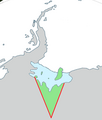
English: Outline map showing the w:Filchner-Ronne Ice Shelf and the unnamed sector of Antarctica lying to its south, between Ellsworth Land (at 80°W) and Coats Land (at 36°W). |
| Source | Generated from File:Antarctica,_territorial_claims.svg (Lokal_Profil) by myself (w:User:Grutness) |
| Author | w:User:Grutness |
This file is licensed under the Creative Commons Attribution-Share Alike 2.5 Generic license.
Attribution: Lokal_Profil
- You are free:
- to share – to copy, distribute and transmit the work
- to remix – to adapt the work
- Under the following conditions:
- attribution – You must give appropriate credit, provide a link to the license, and indicate if changes were made. You may do so in any reasonable manner, but not in any way that suggests the licensor endorses you or your use.
- share alike – If you remix, transform, or build upon the material, you must distribute your contributions under the same or compatible license as the original.
File history
Click on a date/time to view the file as it appeared at that time.
| Date/Time | Thumbnail | Dimensions | User | Comment | |
|---|---|---|---|---|---|
| current | 10:20, 9 July 2011 |  | 235 × 289 (26 KB) | Grutness (talk | contribs) | as before - tidied |
| 10:18, 9 July 2011 |  | 283 × 334 (31 KB) | Grutness (talk | contribs) | Outline map showing the Filchner-Ronne Ice Shelf and the unnamed sector of Antarctica lying to its south, between Ellsworth Land (at 80°W) and Coats Land (at 36°W). Generated from File:Antarctica,_territorial_claims.svg ({{cc-by-sa-2.5|[[:User: |
You cannot overwrite this file.
File usage on Commons
There are no pages that use this file.
File usage on other wikis
The following other wikis use this file:
- Usage on en.wikipedia.org
- South Ice
- Henry Ice Rise
- Korff Ice Rise
- Fowler Ice Rise
- Carlson Inlet
- Hemmen Ice Rise
- Institute Ice Stream
- Edith Ronne Land
- Möller Ice Stream
- Fletcher Ice Rise
- Coal Rock
- Doake Ice Rumples
- Forlidas Pond
- Gambacorta Peak
- Gould Bay
- Grand Chasms
- Hercules Inlet
- McCarthy Inlet
- Spilhaus Inlet
- Ruthven Bluff
- Kershaw Ice Rumples
- Roberts Inlet
- Template:QueenElizabethLand-geo-stub
- Iceberg A-76
Metadata
This file contains additional information such as Exif metadata which may have been added by the digital camera, scanner, or software program used to create or digitize it. If the file has been modified from its original state, some details such as the timestamp may not fully reflect those of the original file. The timestamp is only as accurate as the clock in the camera, and it may be completely wrong.
| Horizontal resolution | 28.35 dpc |
|---|---|
| Vertical resolution | 28.35 dpc |
Hidden category:
