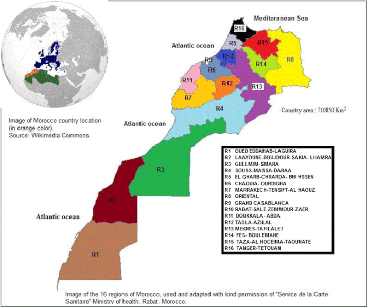
File:Fig-2-Map-of-Morocco-illustrating-the-16-administrative-regions.gif
From Wikimedia Commons, the free media repository
Jump to navigation
Jump to search

Size of this preview: 715 × 599 pixels. Other resolutions: 286 × 240 pixels | 573 × 480 pixels | 778 × 652 pixels.
Original file (778 × 652 pixels, file size: 127 KB, MIME type: image/gif)
File information
Structured data
Captions
Captions
Add a one-line explanation of what this file represents
Summary
[edit]| DescriptionFig-2-Map-of-Morocco-illustrating-the-16-administrative-regions.gif |
English: Fig. 2 Map of Morocco, illustrating the 16 administrative regions. This figure illustrates the 16 administrative regions that make up Morocco |
| Date | |
| Source | Mina Sadeq. "Spatial patterns and secular trends in human leishmaniasis incidence in Morocco between 2003 and 2013", Infectious Diseases of Poverty doi:10.1186/s40249-016-0135-8 |
| Author | Mina Sadeq |
| Permission (Reusing this file) |
Open Access This article is distributed under the terms of the Creative Commons Attribution 4.0 International License ( https://creativecommons.org/licenses/by/4.0/ ), which permits unrestricted use, distribution, and reproduction in any medium, provided you give appropriate credit to the original author(s) and the source, provide a link to the Creative Commons license, and indicate if changes were made. The Creative Commons Public Domain Dedication waiver ( https://creativecommons.org/publicdomain/zero/1.0/ ) applies to the data made available in this article, unless otherwise stated. |
==Licensing==
This file is licensed under the Creative Commons Attribution 4.0 International license.
- You are free:
- to share – to copy, distribute and transmit the work
- to remix – to adapt the work
- Under the following conditions:
- attribution – You must give appropriate credit, provide a link to the license, and indicate if changes were made. You may do so in any reasonable manner, but not in any way that suggests the licensor endorses you or your use.
File history
Click on a date/time to view the file as it appeared at that time.
| Date/Time | Thumbnail | Dimensions | User | Comment | |
|---|---|---|---|---|---|
| current | 15:33, 28 January 2020 |  | 778 × 652 (127 KB) | Abdeaitali (talk | contribs) | Uploaded by the NOA Upload Tool |
You cannot overwrite this file.
File usage on Commons
There are no pages that use this file.