File:Falkland-Islands-Terra-2011-01-23-250m.jpg
Jump to navigation
Jump to search
Size of this preview: 800 × 571 pixels. Other resolutions: 320 × 229 pixels | 640 × 457 pixels | 1,024 × 731 pixels | 1,400 × 1,000 pixels.
Original file (1,400 × 1,000 pixels, file size: 123 KB, MIME type: image/jpeg)
Captions
Captions
Add a one-line explanation of what this file represents
Summary
[edit]
| Description |
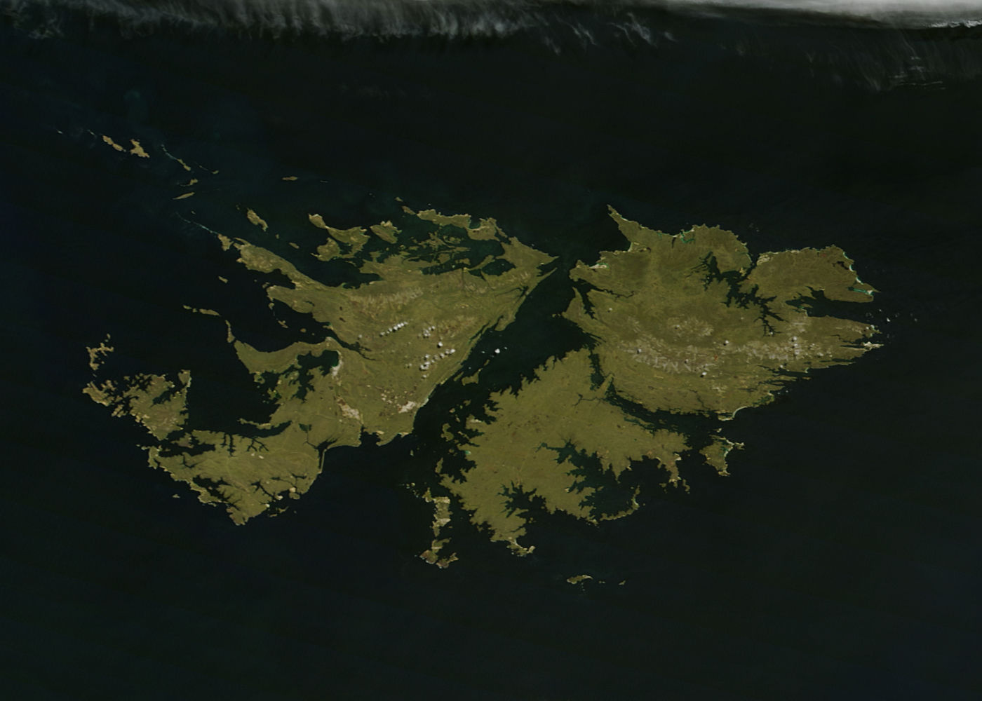
English: The green lands Falkland Islands sparkle in the southern Atlantic Ocean about 250 nautical miles (460 miles) off the coast of southern Argentina. Also known as Islas Malvinas, the archipelago consists of over 775 islands and is a self-governing British Overseas Territory. On January 23, 2011 the Moderate Resolution Imaging Spectroradiometer (MODIS) aboard the Terra Satellite captured this true-color image as it passed over the region. The resolution is 250 meters per pixel. Русский: Зелёные Фолклендские острова искрятся в южном Атлантическом океане на расстоянии 250 морских миль от берега южной Аргентины. Также известный, как Мальвинские острова, этот архипелаг состоит из более чем 775 островов и является само-управляемой Британской заморской территорией. Это изображение было снято в натуральных цветах американским научным спутником Терра 23 января 2011 года. |
| Date | |
| Source | http://modis.gsfc.nasa.gov/gallery/individual.php?db_date=2011-01-29 |
| Author | NASA |
Licensing
[edit]
| This file is in the public domain in the United States because it was solely created by NASA. NASA copyright policy states that "NASA material is not protected by copyright unless noted". (See Template:PD-USGov, NASA copyright policy page or JPL Image Use Policy.) | ||
 |
Warnings:
|
File history
Click on a date/time to view the file as it appeared at that time.
| Date/Time | Thumbnail | Dimensions | User | Comment | |
|---|---|---|---|---|---|
| current | 19:29, 29 January 2011 | | 1,400 × 1,000 (123 KB) | Melikamp (talk | contribs) | {{Information |Description ={{en|1=The green lands Falkland Islands sparkle in the southern Atlantic Ocean about 250 nautical miles (460 miles) off the coast of southern Argentina. Also known as Islas Malvinas, the archipelago consists of over 775 isla |
You cannot overwrite this file.
File usage on Commons
The following 45 pages use this file:
- Falkland Islands
- Category:1961 in the Falkland Islands
- Category:1962 in the Falkland Islands
- Category:1982 in the Falkland Islands
- Category:1983 in the Falkland Islands
- Category:1984 in the Falkland Islands
- Category:1998 in the Falkland Islands
- Category:2001 in the Falkland Islands
- Category:2005 in the Falkland Islands
- Category:2006 in the Falkland Islands
- Category:2008 in the Falkland Islands
- Category:2009 in the Falkland Islands
- Category:2010 in the Falkland Islands
- Category:2011 in the Falkland Islands
- Category:2014 in the Falkland Islands
- Category:2017 in the Falkland Islands
- Category:2018 in the Falkland Islands
- Category:2020 in the Falkland Islands
- Category:2021 in the Falkland Islands
- Category:Bays of the Falkland Islands
- Category:Falkland Islands
- Category:Falkland Islands by century
- Category:Falkland Islands by decade
- Category:Falkland Islands by year
- Category:Falkland Islands in the 18th century
- Category:Falkland Islands in the 1930s
- Category:Falkland Islands in the 1940s
- Category:Falkland Islands in the 1950s
- Category:Falkland Islands in the 1960s
- Category:Falkland Islands in the 1980s
- Category:Falkland Islands in the 1990s
- Category:Falkland Islands in the 19th century
- Category:Falkland Islands in the 2000s
- Category:Falkland Islands in the 2010s
- Category:Falkland Islands in the 2020s
- Category:Falkland Islands in the 20th century
- Category:Falkland Islands in the 21st century
- Category:Geography of the Falkland Islands
- Category:Hills of the Falkland Islands
- Category:Infrastructure in the Falkland Islands
- Category:Islands of the Falkland Islands
- Category:Lighthouses in the Falkland Islands
- Category:Maps of the Falkland Islands
- Category:Nature of the Falkland Islands
- Category:Transport infrastructure in the Falkland Islands
File usage on other wikis
The following other wikis use this file:
- Usage on ar.wikipedia.org
- Usage on arz.wikipedia.org
- Usage on ast.wikipedia.org
- Usage on br.wikipedia.org
- Usage on ca.wikipedia.org
- Usage on ceb.wikipedia.org
- Usage on cy.wikipedia.org
- Usage on en.wikipedia.org
- Usage on eo.wikipedia.org
- Usage on eo.wikinews.org
- Usage on es.wikipedia.org
- Usage on es.wiktionary.org
- Usage on fr.wikipedia.org
- Usage on fr.wikivoyage.org
- Usage on ga.wikipedia.org
- Usage on gd.wikipedia.org
- Usage on gl.wikipedia.org
- Usage on ia.wikipedia.org
- Usage on incubator.wikimedia.org
- Usage on it.wikiquote.org
- Usage on kbd.wikipedia.org
- Usage on ko.wikipedia.org
- Usage on mt.wikipedia.org
- Usage on nn.wikipedia.org
- Usage on oc.wikipedia.org
- Usage on pap.wikipedia.org
- Usage on pl.wikipedia.org
- Usage on ru.wikinews.org
- Usage on tt.wikipedia.org
- Usage on vec.wikipedia.org
- Usage on www.wikidata.org
- Usage on zu.wikipedia.org