File:Europa voll flach.png
Jump to navigation
Jump to search

Size of this preview: 737 × 599 pixels. Other resolutions: 295 × 240 pixels | 590 × 480 pixels | 944 × 768 pixels | 1,259 × 1,024 pixels | 2,046 × 1,664 pixels.
Original file (2,046 × 1,664 pixels, file size: 3.1 MB, MIME type: image/png)
Captions
Captions
Add a one-line explanation of what this file represents
| Description |
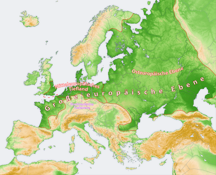
Deutsch: Karte: Große europäische Ebene, Mitteleuropäisches Tiefland, Osteuropäische Ebene und Norddeutsche Tiefebene
English: Map: Great European Plain with East European Plain and North European Plain |
| Date | |
| Source | Own work, using these files: (1), (2) (licensed cc-by-sa-3.0/GFDL) |
| Author | Maximilian Dörrbecker (Chumwa), based on works by San Jose, Generic Mapping Tool and ETOPO2 |
| Permission (Reusing this file) |
I, the copyright holder of this work, hereby publish it under the following license: This file is licensed under the Creative Commons Attribution-Share Alike 2.5 Generic license.
Sie dürfen das Bild zu den folgenden Bedingungen nutzen:
|
File history
Click on a date/time to view the file as it appeared at that time.
| Date/Time | Thumbnail | Dimensions | User | Comment | |
|---|---|---|---|---|---|
| current | 05:36, 5 October 2009 | | 2,046 × 1,664 (3.1 MB) | Chumwa (talk | contribs) | {{Information |Description= *{{ de }} Karte: Große europäische Ebene, Mitteleuropäisches Tiefland, Osteuropäische Ebene und Norddeutsche Tiefebene *{{ en }} Map: Great European Plain with East European Plain and North European Plain |Source={{Own}}, u |
You cannot overwrite this file.
File usage on Commons
The following page uses this file:
File usage on other wikis
The following other wikis use this file:
- Usage on de.wikipedia.org