File:Estado Boliviano.svg
Jump to navigation
Jump to search

Size of this PNG preview of this SVG file: 494 × 600 pixels. Other resolutions: 198 × 240 pixels | 395 × 480 pixels | 632 × 768 pixels | 843 × 1,024 pixels | 1,686 × 2,048 pixels | 700 × 850 pixels.
Original file (SVG file, nominally 700 × 850 pixels, file size: 639 KB)
Captions
Captions
Add a one-line explanation of what this file represents
Summary
[edit]
| Description |
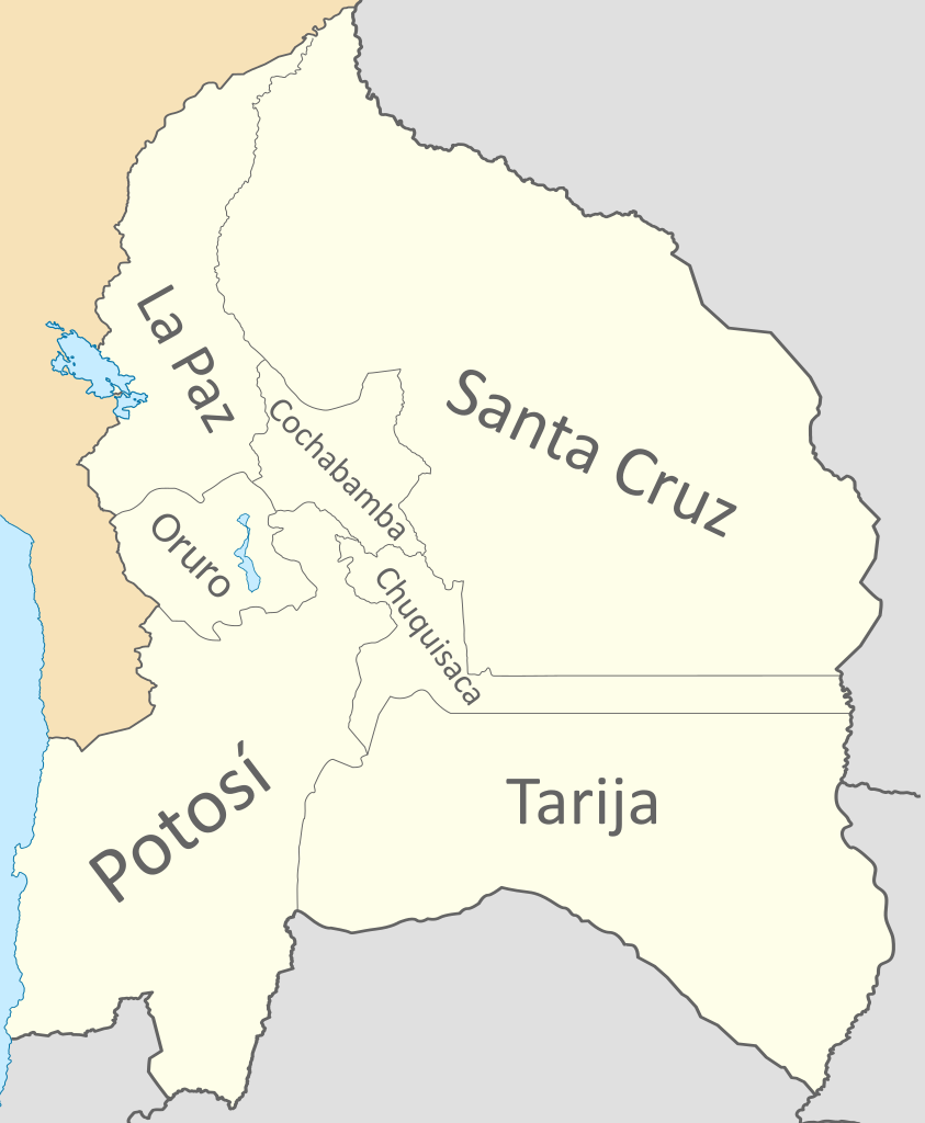
Español: Mapa del Estado Boliviano, Confederación Perú-Boliviana.
Incluye el Corredor de Atacama, disputado con Chile, el Chaco, disputado con Paraguay, Tarija, disputada con Argentina y la Puna de Atacama (límites imprecisos en la época).
English: Map of the Bolivian State, Peru-Bolivian Confederation.
It includes the Atacama Corridor, disputed with Chile, the Chaco, disputed with Paraguay, Tarija, disputed with Argentina and the Puna de Atacama (imprecise limits at the time). |
| Date | |
| Source |
Own work Coastline extracted from: File:Ecuador location map.svg & File:Chile location map.svg by NordNordWest & File:Peru location map.svg by Spischot |
| Author |
Janitoalevic Coastline extracted from: File:Ecuador location map.svg & File:Chile location map.svg by NordNordWest & File:Peru location map.svg by Spischot |
| Other versions | File:Divisiones administrativas de la Confederación Perú-Boliviana.svg |
Licensing
[edit]

|
Permission is granted to copy, distribute and/or modify this document under the terms of the GNU Free Documentation License, Version 1.2 or any later version published by the Free Software Foundation; with no Invariant Sections, no Front-Cover Texts, and no Back-Cover Texts. A copy of the license is included in the section entitled GNU Free Documentation License. |
This file is licensed under the Creative Commons Attribution-Share Alike 3.0 Unported license.
- You are free:
- to share – to copy, distribute and transmit the work
- to remix – to adapt the work
- Under the following conditions:
- attribution – You must give appropriate credit, provide a link to the license, and indicate if changes were made. You may do so in any reasonable manner, but not in any way that suggests the licensor endorses you or your use.
- share alike – If you remix, transform, or build upon the material, you must distribute your contributions under the same or compatible license as the original.
File history
Click on a date/time to view the file as it appeared at that time.
| Date/Time | Thumbnail | Dimensions | User | Comment | |
|---|---|---|---|---|---|
| current | 02:28, 22 July 2020 | | 700 × 850 (639 KB) | Janitoalevic (talk | contribs) | + Oruro * Límites mejorados |
| 17:10, 1 December 2019 |  | 700 × 850 (652 KB) | Janitoalevic (talk | contribs) | Added Tarija | |
| 23:55, 27 August 2019 |  | 700 × 850 (681 KB) | Janitoalevic (talk | contribs) | User created page with UploadWizard |
You cannot overwrite this file.
File usage on Commons
The following 2 pages use this file:
File usage on other wikis
The following other wikis use this file:
- Usage on ar.wikipedia.org
- Usage on en.wikipedia.org
- Subdivisions of the Peru–Bolivian Confederation
- Bolivian Republic (Peru-Bolivian Confederation)
- Cochabamba Department (Peru–Bolivian Confederation)
- Chuquisaca Department (Peru–Bolivian Confederation)
- La Paz Department (Peru–Bolivian Confederation)
- Oruro Department (Peru–Bolivian Confederation)
- Potosí Department (Peru–Bolivian Confederation)
- Santa Cruz Department (Peru–Bolivian Confederation)
- Tarija Department (Peru–Bolivian Confederation)
- Usage on es.wikipedia.org
- Estado Boliviano (Confederación Perú-Boliviana)
- Organización territorial de la Confederación Perú-Boliviana
- Departamento de Cochabamba (Confederación Perú-Boliviana)
- Departamento de Chuquisaca (Confederación Perú-Boliviana)
- Departamento de La Paz (Confederación Perú-Boliviana)
- Departamento de Potosí (Confederación Perú-Boliviana)
- Departamento de Santa Cruz (Confederación Perú-Boliviana)
- Departamento de Tarija (Confederación Perú-Boliviana)
- Departamento de Oruro (Confederación Perú-Boliviana)
- Anexión de Tarija, Salta y Jujuy a la Confederación Perú-Boliviana
- Usage on tr.wikipedia.org
- Usage on www.wikidata.org