File:Erosion de lLa digue du Bourg d'Ault sur 100 ans.jpg
Jump to navigation
Jump to search
Size of this preview: 450 × 600 pixels. Other resolutions: 180 × 240 pixels | 360 × 480 pixels | 576 × 768 pixels | 768 × 1,024 pixels | 2,100 × 2,800 pixels.
Original file (2,100 × 2,800 pixels, file size: 2.76 MB, MIME type: image/jpeg)
Captions
Captions
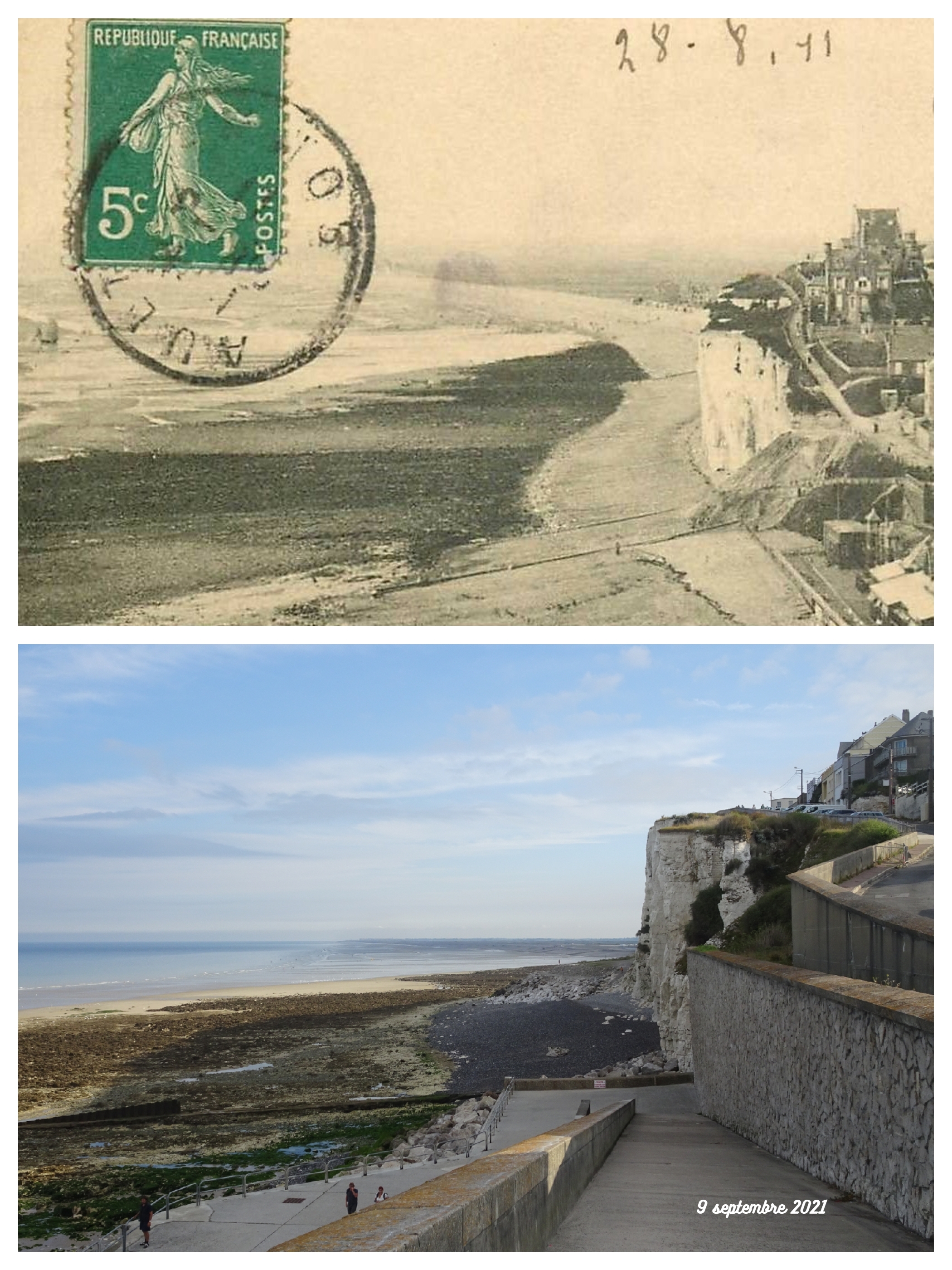
Collapse over 100 years of the seafront of the seaside resort of Bourg-d'Ault
Summary
[edit]| Description |
Français : La comparaison de la position de la falaise entre 1911 et 2021, montre le recul de la falaise d' Ault sur 100 années. L'érosion, due à la montée des eaux provoquée par réchauffement climatique, a été de 70 m pour le seul xxe siècle English: The comparison of the position of the cliff between 1911 and 2021, shows the retreat of the cliff of Ault over 100 years. Erosion, due to the rise in water caused by global warming, was 70 m for the 20th century alone
|
||||
| Date | |||||
| Source | Own work | ||||
| Author | Pierre André Leclercq | ||||
| Permission (Reusing this file) |
|
.jpg)

.jpg)
.jpg)
| Camera location | | View this and other nearby images on: OpenStreetMap |
|---|
Licensing
[edit]
I, the copyright holder of this work, hereby publish it under the following license:
This file is licensed under the Creative Commons Attribution-Share Alike 4.0 International license.
- You are free:
- to share – to copy, distribute and transmit the work
- to remix – to adapt the work
- Under the following conditions:
- attribution – You must give appropriate credit, provide a link to the license, and indicate if changes were made. You may do so in any reasonable manner, but not in any way that suggests the licensor endorses you or your use.
- share alike – If you remix, transform, or build upon the material, you must distribute your contributions under the same or compatible license as the original.
File history
Click on a date/time to view the file as it appeared at that time.
| Date/Time | Thumbnail | Dimensions | User | Comment | |
|---|---|---|---|---|---|
| current | 21:32, 3 July 2023 | | 2,100 × 2,800 (2.76 MB) | Pierre André Leclercq (talk | contribs) | Uploaded own work with UploadWizard |
You cannot overwrite this file.
File usage on Commons
The following 7 pages use this file:
- User:Pierre André Leclercq/Gallery/Challenges depuis 2014
- User:Pierre André Leclercq/gallery/Challenges depuis 2014
- User:Ww2censor/Recent philatelic uploads/2023 July 1-4
- Commons:Photo challenge/2023 - July - climate change
- Commons:Photo challenge/2023 - July - climate change/Voting
- Commons:Photo challenge/2023 - July - climate change/Voting/Result
- Commons:WikiProject Postcards/new files/2023 July 3
File usage on other wikis
The following other wikis use this file:
- Usage on fr.wikipedia.org