File:English loyalties 1216.png
Jump to navigation
Jump to search
No higher resolution available.
English_loyalties_1216.png (215 × 274 pixels, file size: 34 KB, MIME type: image/png)
Captions
Captions
Add a one-line explanation of what this file represents
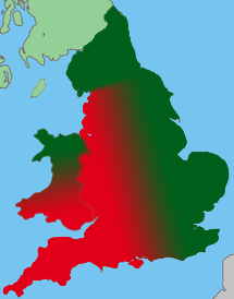
| Description | A map showing the Loyalist and Rebel territories in England in 1216. Using description from Warren, "King John", p.250. |
| Date | (UTC) |
| Source | |
| Author |
|
| This is a retouched picture, which means that it has been digitally altered from its original version. Modifications: Territories marked out in colours. The original can be viewed here: Uk map england green.png:
|
I, the copyright holder of this work, hereby publish it under the following licenses:
This file is licensed under the Creative Commons Attribution-Share Alike 3.0 Unported license.
- You are free:
- to share – to copy, distribute and transmit the work
- to remix – to adapt the work
- Under the following conditions:
- attribution – You must give appropriate credit, provide a link to the license, and indicate if changes were made. You may do so in any reasonable manner, but not in any way that suggests the licensor endorses you or your use.
- share alike – If you remix, transform, or build upon the material, you must distribute your contributions under the same or compatible license as the original.

|
Permission is granted to copy, distribute and/or modify this document under the terms of the GNU Free Documentation License, Version 1.2 or any later version published by the Free Software Foundation; with no Invariant Sections, no Front-Cover Texts, and no Back-Cover Texts. A copy of the license is included in the section entitled GNU Free Documentation License. |
You may select the license of your choice.
Original upload log
[edit]
This image is a derivative work of the following images:
- File:Uk_map_england_green.png licensed with Cc-by-sa-3.0, GFDL
- 2008-03-31T04:13:22Z UKPhoenix79 643x1075 (65653 Bytes) {{Information |Description=Image of England in the UK |Source=[[:Image:British Isles United Kingdom.svg]] |Date=[[2008-03-29]] |Author= [[User:UKPhoenix79|UKPhoenix79]] |Permission= |other_versions=[[:Image:Uk map england gre
Uploaded with derivativeFX
File history
Click on a date/time to view the file as it appeared at that time.
| Date/Time | Thumbnail | Dimensions | User | Comment | |
|---|---|---|---|---|---|
| current | 12:25, 31 December 2010 | | 215 × 274 (34 KB) | Hchc2009 (talk | contribs) | {{Information |Description=A map showing the Loyalist and Rebel territories in England in 1216. Using description from Warren, "King John", p.250. |Source=*File:Uk_map_england_green.png |Date=2010-12-31 12:25 (UTC) |Author=*[[:File:Uk_map_england_gr |
You cannot overwrite this file.
File usage on Commons
There are no pages that use this file.