File:Enceladus polar temps.jpg

Original file (973 × 965 pixels, file size: 400 KB, MIME type: image/jpeg)
Captions
Captions
Summary
[edit]| DescriptionEnceladus polar temps.jpg |
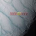
English: High-resolution, en:false-color view of "tiger stripe" fractures in the south polar region of Saturn's moon Enceladus with en:brightness temperatures from the CIRS instrument overlain.
Original caption released with image: This image shows the warmest places in the south polar region of Saturn's moon Enceladus. The unexpected temperatures were discovered by Cassini's composite en:infrared en:spectrometer during a close flyby on en:July 14, en:2005. The image shows how these temperatures correspond to the prominent, bluish fractures dubbed "tiger stripes," first imaged by Cassini's imaging science subsystem cameras. Working together the two teams were able to pinpoint the exact location of the warmest regions on Enceladus. The composite infrared spectrometer instrument measured the infrared heat radiation from the surface at wavelengths between 9 and 16.5 en:micrometres within each of the 10 squares shown here. Each square is 6 en:kilometers (4 miles) across. The color of each square, and the number shown above it, describe the composite infrared spectrometer's measurement of the approximate average temperature of the surface within that square. The warmest temperature squares, at 91 and 89 degrees en:Kelvin (-299 and -296 °F), are located over one of the "tiger stripe" fractures. They contrast sharply with the surrounding temperatures, which are in the range 74 to 81 degrees Kelvin (-326 to -313 °F). The detailed composite infrared spectrometer data suggest that small areas near the fracture are at substantially higher temperatures, well over 100 degrees Kelvin (-279 °F). Such "warm" temperatures are unlikely to be due to heating of the surface by the feeble sunlight striking Enceladus' south pole. They are a strong indication that internal heat is leaking out of Enceladus and warming the surface along these fractures. Evaporation of this relatively warm ice probably generates the cloud of en:water vapor detected above Enceladus' south pole by several other Cassini instruments. Scientists are unsure how the internal heat reaches the surface. The process might involve liquid water, slushy brine, or soft but solid ice. The imaging science subsystem image is an enhanced color view with a pixel scale of 122 en:meters (400 ft) that was acquired at the same time as the composite infrared spectrometer data. It covers a region 125 kilometers (75 miles) across. The spacecraft's distance from Enceladus was 21,000 kilometers (13,000 miles). The broad bluer fractures that can be seen running from the upper left to the lower right of the image are 1 to 2 kilometers (0.6 to 1.2 miles) wide and more than 100 kilometers (60 miles) long. The fractures are thought to be bluer than the surrounding surface because coarser-grained ice (which has a blue color just as thick masses of ice, like glaciers and icebergs, do on Earth) has been exposed in the fractures. The color image was constructed using an ultraviolet filter (centered at 338 nanometers) in the blue channel, a clear filter in the green channel, and an infrared filter (centered at 930 nanometers) in the red channel. The Cassini-Huygens mission is a cooperative project of NASA, the European Space Agency and the Italian Space Agency. The Jet Propulsion Laboratory, a division of the California Institute of Technology in Pasadena, manages the Cassini-Huygens mission for NASA's Science Mission Directorate, Washington, D.C. The imaging team consists of scientists from the US, England, France, and Germany. The imaging operations center and team lead (Dr. C. Porco) are based at the Space Science Institute in Boulder, Colo. For more information about the Cassini-Huygens mission, visit http://saturn.jpl.nasa.gov and the Cassini imaging team home page, http://ciclops.org. Credit: NASA/JPL/GSFC/Space Science Institute |
| Source |
This file is lacking source information.
Please edit this file's description and provide a source. |
| Author |
This file is lacking author information.
|
Licensing
[edit]| Public domainPublic domainfalsefalse |
| This file is in the public domain in the United States because it was solely created by NASA. NASA copyright policy states that "NASA material is not protected by copyright unless noted". (See Template:PD-USGov, NASA copyright policy page or JPL Image Use Policy.) |  | |
 |
Warnings:
|
Original upload log
[edit]- 2005-12-02 22:58 Volcanopele 973×965×8 (409713 bytes) High-[[resolution]], [[false-color]] view of "tiger stripe" fractures in the south polar region of [[Saturn (planet)|Saturn]]'s moon [[Enceladus (moon)|Enceladus]] with [[brightness temperature]]s from the CIRS instrument overlain. '''Original caption re
File history
Click on a date/time to view the file as it appeared at that time.
| Date/Time | Thumbnail | Dimensions | User | Comment | |
|---|---|---|---|---|---|
| current | 13:33, 6 December 2007 |  | 973 × 965 (400 KB) | File Upload Bot (Magnus Manske) (talk | contribs) | {{BotMoveToCommons|en.wikipedia}} {{Information |Description={{en|High-resolution, en:false-color view of "tiger stripe" fractures in the south polar region of Saturn's moon [[:en:Enceladus (moon)|En |
You cannot overwrite this file.
File usage on Commons
The following 2 pages use this file:
File usage on other wikis
The following other wikis use this file:
- Usage on als.wikipedia.org
- Usage on ca.wikipedia.org
- Usage on de.wikipedia.org
- Usage on en.wikinews.org
- Usage on fr.wikipedia.org
- Usage on th.wikipedia.org
- Usage on www.wikidata.org
Metadata
This file contains additional information such as Exif metadata which may have been added by the digital camera, scanner, or software program used to create or digitize it. If the file has been modified from its original state, some details such as the timestamp may not fully reflect those of the original file. The timestamp is only as accurate as the clock in the camera, and it may be completely wrong.
| _error | 0 |
|---|